
Berlin-Wilmersdorf
|
Wilmersdorf district of Berlin |
|
|---|---|
  |
|
| Coordinates | 52 ° 29 ′ 0 ″ N , 13 ° 19 ′ 0 ″ E |
| height | 43 m above sea level NN |
| surface | 7.16 km² |
| Residents | 102,619 (Dec. 31, 2019) |
| Population density | 14,332 inhabitants / km² |
| Postcodes | 10707, 10709, 10713, 10715, 10717, 10719, 10777, 14197 |
| District number | 0402 |
| Administrative district | Charlottenburg-Wilmersdorf |
Wilmersdorf is a district in the Charlottenburg-Wilmersdorf district of Berlin . The historic core of Alt-Wilmersdorf is on the Wilhelmsaue street. Until the merger with the former Charlottenburg district in 2001, there was an independent district of Wilmersdorf in the western part of Berlin . This included the current districts of Halensee , Schmargendorf , Grunewald and the eponymous district of Wilmersdorf.
Geographical location and town planning
Wilmersdorf is located on the Teltow plateau in the southwest of today's Berlin. It is bordered to the north by the district of Charlottenburg , in the west on the districts Halensee and Schmargendorf , on the south by the district of Steglitz-Zehlendorf belonging districts Steglitz ( Breitenbachplatz and south sides of Kreuznacher road ) and Dahlem and to the east to Tempelhof-Schöneberg belonging districts of Friedenau (at the Rheingauviertel ) and Schöneberg .

Between Olivaer Platz and Cicerostraße, Kurfürstendamm forms the northern border to the neighboring district of Charlottenburg, so that the house numbers of the boulevard on the southern side of the street already belong to Wilmersdorf at this height.
The so-called Wilmersdorfer Carstenn figure by Johann Anton Wilhelm von Carstenn was created on the site of the former Wilmersdorf manor from 1870 as the urban planning center of the district .
The peculiarity of the Carstenn figure is characterized by a generously laid out Mittelallee (laid out between 1872 and 1874 under the name Kaiserstraße , from 1874 to 1950: Kaiserallee , from 1950: Bundesallee ) with streets running towards it, which in turn are captured by four symmetrical decorative squares , namely Nikolsburger Platz , Fasanenplatz , Nürnberger Platz and Prager Platz .
During the Second World War , the buildings on the eastern side of the Wilmersdorfer Carstenn figure were badly damaged. The urban planning of the 1960s with the car-friendly expansion of Bundesallee, Spichernstrasse and Nürnberger Platz also destroyed the image of a closed, symmetrical ensemble, so that the figure is barely recognizable even from the air.
The area west of the Bundesallee suffered significantly less damage, so that the old urban structure can be seen much better here. Nikolsburger Platz and Fasanenplatz were preserved as central decorative places .
history

Settlement history
It was founded probably by 1220 as part of the national expansion of the young Mark Brandenburg , to their stabilization askanischen Marquis settlers called into the country. A village of the Slavic pre-population very likely did not exist here. Wilmerstorff was first mentioned in a document in 1293 . It was owned by the Uradelsfamilie of Wilmer Dorff .
Settlers from Swabia , Thuringia , Flanders and Westphalia living from agriculture and fishing in the Wilmersdorfer lake , which for glacial glacial trough of Grunewaldseenkette belonged and 1915 after long silting processes was filled. After changing ownership, Wilmersdorf became a lordly dominial property , while Schmargendorf fell to the von Wilmersdorff family. Extensive sheep breeding has long been the focus of the work.
Millions of farmers in the early days


In the middle of the 18th century, the first Berliners in the rapidly growing city acquired land and farmhouses in "Deutsch-Wilmersdorf" and set up summer residences in the Wilhelmsaue , the original village center, which is now between Mehlitzstrasse and Blissestrasse . In the middle of the 19th century, land speculators, construction investors and the space-dependent Ringbahn bought their fields from various large farmers who, thanks to the unexpected financial blessing, went down in history as " millions of farmers ", such as the Gieseler and Mehlitz families. Otto Schramm established its reputation as a seaside resort in Wilmersdorf with the bathing establishment at Wilmersdorfer See and the Schramm dance palace .
The Eva Lichtspiele were founded in 1913. This era ended when the lake was filled in. Sports fields were built on the lake grounds, which were incorporated into the Wilmersdorf Volkspark green corridor in the 1920s . This inner-city green corridor in the formerly swampy lowlands (Fenn) extends from the neighboring Schöneberg Rudolph-Wilde-Park over the Fennsee to the city motorway . The so-called "Schrammblock" was built on the grounds of the bathing establishment between 1925 and 1928 according to plans by the architect Jürgen Bachmann . The residential complex with one of the first large underground garages, courtyard terraces and front gardens fills the entire square between the streets Am Volkspark , Schrammstraße , Hildegardstraße and Livländische Straße in one building.
Historical core: Wilhelmsaue

Another large farming family, the Blisse family (namesake of Blissestrasse), enabled the construction of an orphanage, the "Blissestift" in Wilhelmsaue , in 1911 with a foundation worth three million marks (adjusted for purchasing power in today's currency: around 17 million euros). Various municipal facilities are now housed in the historic building, including a school day care center and an all-day care facility .
Also in the Wilhelmsaue is the Auenkirche from the years 1895 to 1897. The neo - Gothic three - aisled brick building with the colored Christ mosaic above the entrance portal comes from Max Spitta and replaced the old Wilmersdorfer village church from 1772, whose predecessor fell victim to the fire of 1766. At Wilhelmsaue 126 is the oldest house in Wilmersdorf, the Schoeler-Schlösschen from 1752, which - like the adjoining small Schoelerpark - bears the name of its last resident, the ophthalmologist and medical advisor Heinrich Schoeler (1844–1918).
As a district of Berlin
In the 19th century, the name Deutsch Wilmersdorf was used to distinguish the village between Märkisch Wilmersdorf and Wendisch Wilmersdorf . On April 1, 1906, the municipality received town charter and the official name Deutsch-Wilmersdorf. On April 1, 1907, Deutsch-Wilmersdorf left the Teltow district and became an independent urban district . The first and only mayor and, after 1909, also mayor was Ernst Habermann (1866-1958), who had held the office of mayor since 1897 and later became the namesake of Habermannplatz.
From 1912 the city was called Berlin-Wilmersdorf . October 1, 1920, the city as was Wilmersdorf for Greater Berlin incorporated; at that time it already had 139 468 inhabitants.
The Jewish Wilmersdorf
_Synagoge_Wilmersdorf.JPG)
During the Weimar Republic, the district had a strong Jewish population; In 1933 it was 13.5%. Of the high school students, 30% were Jewish, there were five Jewish private schools. Many well-known artists and writers lived in Wilmersdorf, including George Grosz , Egon Erwin Kisch , Heinrich Mann , Anna Seghers and Arnold Zweig . A memorial stone commemorates the Reich Foreign Minister Walter Rathenau , who was murdered by right-wing extremists in 1922 on Koenigsallee in Grunewald . The Jewish community initially held its services in private synagogues ; In 1929 a large community synagogue was built on Prinzregentenstrasse , which could accommodate 2,300 visitors. The building was partially destroyed by SA troops in the so-called " Reichspogromnacht " from November 9th to 10th, 1938 , the remains of the building were removed in 1958. A plaque commemorates the Wilmersdorf synagogue on the residential buildings located here today.
In 2007, the Chabad Jewish Education Center was opened on Münsterschen Strasse for the growing Jewish community. In addition to a kindergarten, a school and a kosher restaurant, it also houses a synagogue.
time of the nationalsocialism
Forced laborers from various nations were housed in Wilhelmsaue 40 during the Second World War . As several documents show, it was a warehouse under the direction of the Wilmersdorf district office at the time.
Mayor of Wilmersdorf
| Period | Surname |
|---|---|
| 1875-1877 | Westhoff |
| 1877-1886 | Robert Heinrich Eduard Wegener |
| 1886-1892 | Karl August Bernhard Güntzel |
| 1892-1897 | Friedrich Wilhelm Karl Stork |
| 1897-1921 | Ernst Habermann (from 1906 mayor, from 1909 mayor) |
Source: District Office Charlottenburg-Wilmersdorf
Districts and city quarters

Ludwigkirchplatz
The area around Ludwigkirchplatz , between Lietzenburger Straße in the north and Hohenzollerndamm in the south, with the eponymous St. Ludwig's Church , is characterized by gastronomy and the proximity to Kurfürstendamm . The Kiez , sometimes referred to in the media as "Fasanenkiez", is primarily the area where the district goes out; In addition to numerous restaurants, there are many cafes, bars and retail outlets.
To the east of Ludwigkirchplatz, between Fasanenplatz and Bundesallee , you will find the Haus der Berliner Festspiele , the Bar every reason and the arts faculty of the University of the Arts.
Güntzelkiez
The area south of Hohenzollerndamm , between Brandenburgischer Strasse , Bundesallee and Berliner Strasse , is generally known as Güntzelkiez , named after the central Güntzelstrasse and the adjacent subway station of the same name . The quarter is characterized by several well-preserved streets from the Wilhelminian era and the jewelry squares Hohenzollernplatz and Nikolsburger Platz .
Prague square
The Prager Platz , east of Federal Avenue , in 1870 created as Schmuckplatz and has long been one of the cultural centers in West Berlin. During the Second World War , the square and the surrounding area were almost completely destroyed and then lay fallow . The streets surrounding it and the nearby Nürnberger Platz were made suitable for cars in the 1960s in order to facilitate access to the City West to the north . In 1987, on the occasion of the 750th anniversary of Berlin , the square was redesigned from an aesthetic point of view. Today it is again a lively district center with supermarkets, restaurants, cafes and a shopping center. It is also a recreational and leisure area for the surrounding residential areas.
Fehrbelliner Platz

The area around Fehrbelliner Platz was largely undeveloped until the 1920s. In the north of the square, the Preußenpark was laid out in 1904/05 (initial names first Platz D then Preußen-Platz ). The residential area there was built in the Bauhaus style. Most of the streets were named after provinces of the German Empire , such as Sächsische Strasse , Pommersche Strasse or Württembergische Strasse. Further north you get to Kurfürstendamm with the Schaubühne on Lehniner Platz , which at this point forms the northern border of the district. Also in the 1920s, the first government buildings were erected on Fehrbelliner Platz. The subway connection of the same name was opened in 1913. Large-scale expansions of the square took place under the National Socialists , most recently with the new Wilmersdorf Town Hall , which was completed in 1943. In the southern vicinity of the square is Germany's oldest mosque, the so-called Wilmersdorfer Mosque , which was built in 1924 on an initiative of Muslim students living in Berlin. Berlin Widely known and loved is the so-called Thai meadow in Prussia park , a allwöchentliches picnic on Sunday, East Asian descent in which people from all over Berlin gather in the park to offer at improvised stalls dishes from their countries of origin.
Wilhelmsaue

The Wilhelmsaue with the Auenkirche and the Schoeler-Schlösschen is the old town center of the former rural community Wilmersdorf.
The Berliner Straße , the historic connecting road between Wilmersdorf and Old Berlin , runs north of Wilhelmsaue and is still one of the main traffic arteries in the district. To the south of the Wilhelmsaue lies the Volkspark Wilmersdorf , in place of the former Wilmersdorfer See , once on the outskirts of the historic rural community of Wilmersdorf. As a result of the increasingly urban environment of the historic town center, the lake was drained in 1915 due to heavy pollution and increasing siltation. In contrast, the Fennsee , which borders the Volkspark to the west, has stood the test of time .
Bundesplatz
In 1950 Kaiserplatz and Kaiserallee were renamed Bundesplatz and Bundesallee to emphasize West Berlin's affiliation with the Federal Republic . The former Kaiserplatzviertel was built around the square from 1888 . The quarter was designed primarily for upper-class living with spacious apartments and was largely retained in its former form, especially west of Bundesplatz. Unlike the Bundesplatz itself, which, like the Bundesallee, was redesigned to make it suitable for cars in the 1960s, which largely made the former park-like character of the square disappear. The quarter became famous through the long-term documentary Berlin - Ecke Bundesplatz , which filmed selected residents from 1986 to 2012 and documented a quarter of a century of contemporary Berlin history.
Rheingauviertel

The Rheingauviertel was completed shortly before the First World War as a country house colony based on the English model and has been preserved in this form almost unchanged to this day. The streets are named after cities and towns in the Rheingau and in the motifs of the decorative elements on the facades there are numerous references to viticulture in the eponymous region. Around the central Rüdesheimer Platz there is a colorful mix of gastronomy and retail. In the summer months, the Rheingau wine fountain is located on the square every year , where different wineries from the Rheingau offer sparkling wine and wine.
For the New York Times , the Rüdesheimer Straße flanking the square is one of the twelve most beautiful streets in Europe.
Artist colony

In the south of the Rheingauviertel is the artist colony , historically consisting of three large-scale Bauhaus-style blocks of flats . The settlement was built by the Cooperative of German Stage Members (GDBA) and the Protection Association of German Writers from 1927 and has housed numerous writers and other cultural workers throughout its history. Above all, the houses should be functional and offer affordable living space and thus represent a contrast to the spacious Rheingauviertel in the north or the upper-class streets of Steglitz in the south . At the same time, the concept of the “garden city” of the Rheingauviertel was continued here. There was no building on the backyard, instead the inner block areas were laid out as green courtyards. In the center of the colony, Ludwig-Barnay-Platz, formerly Laubenheimer Platz, which is also lushly green , was laid out as a meeting center for the residents.
The original plan was to build a fourth apartment block in the direction of Breitenbachplatz . However, this was stopped by the Nazis after the " seizure of power ". In March 1933 there were raids and arrests as well as book burnings of “Communist and Marxist” literature by the SA on the central Lauenheimer Platz . After the war, the settlement was supplemented by additional apartment blocks, which, however, mainly served to procure the urgently needed housing in the post-war years and did not fit in with the architectural concept of the garden city.
Embassies
In the district there are embassies and diplomatic missions from the following countries:
- Republic of Burundi
- Republic of Gabon
- Republic of Malawi
- Islamic Republic of Pakistan
- Cultural Office of the Embassy of the Kingdom of Saudi Arabia
Parks and gardens
traffic
Transportation
In Wilmersdorf which are underground stations of line U9
and the underground stations on the U3 line
The U7 crosses the paths of the lines U3 and U9 and holds in Wilmersdorf the following subway stations:
The S-Bahn trains on the S41, S42 and S46 ring lines stop at the following Wilmersdorfer train stations:
- Hohenzollerndamm ,
- Heidelberger Platz (formerly: Bahnhof Berlin-Schmargendorf ) and
- Bundesplatz (until 1993 this station was called Berlin-Wilmersdorf, before that until 1938 Berlin-Wilmersdorf-Friedenau ).
While the S-Bahn station Berlin-Wilmersdorf has been called Bundesplatz since the day the southern ring line was reopened on December 17, 1993, like the underground station on the U9 line below , the one on the suburb of Friedenau between the S-Bahn stations Innsbrucker Platz and Freight station in Berlin-Wilmersdorf , located on Bundesplatz, abandoned in the 1970s.
- Historic underground stations on the U3 line

.jpg)


Private transport
A busy connection through Wilmersdorf is the section of the A 100 city motorway , which runs between junctions 14 - Schmargendorf (formerly: Wilmersdorf motorway junction ) and 17 - Innsbrucker Platz . At junction 14, the former A 104 leads south to Steglitz. Part of it is a feeder to the A 100 and is built over with residential buildings on Schlangenbader Strasse . Other important traffic arteries in Wilmersdorf are
- the federal avenue ,
- the Hohenzollerndamm ,
- the south-west parade ,
- the Wiesbaden street and
- the Mecklenburgische Strasse .
Buildings


- The former Mosse-Stift was built as an interdenominational orphanage in 1893 at the instigation of the German-Jewish entrepreneur Rudolf Mosse . In the castle-like complex, in addition to other socio-educational institutions, several children and youth groups are still housed.
- The WOGA complex on Lehniner Platz is an urban ensemble that was built by Erich Mendelsohn from 1925 . The complex should combine culture, shopping and living. The Schaubühne on Lehniner Platz is located in the head building of the facility, the former Kino Universum .
- The Sankt-Gertrauden Hospital , completed in 1930, received stained glass and an apse mosaic by Charles Crodel in 1945, along with additions from 1973.
- The Schlangenbader Straße motorway development is unique in the world. It dates from the time when West Berlin was an island in the 1970s and was an attempt to make efficient use of the scarce inner city space.
- A specialty in Wilmersdorf are the lavishly designed underground stations from the imperial era on the U3 line between the Hohenzollernplatz and Rüdesheimer Platz stations .
Sacred building
Churches
- Old Lutheran Church of the Holy Cross , built 1907–1908 by Heinrich Straumer
- Evangelical Our Father Church , built 1959–1961 according to plans by Werner March
- Evangelical Auenkirche , neo-Gothic brick building, built 1895–1897
- First Church of Christ, Christian Science in Wilhelmsaue 112
- Evangelical Church on Hohenzollernplatz , built 1930–1933 by Fritz Höger and Ossip Klarwein in the style of north German brick expressionism
- Roman Catholic Church of St. Ludwig on Ludwigkirchplatz , built in 1897
- Roman Catholic Church of St. Marien on Bergheimer Platz , built 1913–1914
- Evangelical Lindenkirche , built 1935–1936
- Russian Orthodox Cathedral of the Resurrection of Christ , built 1936–1938
- Roman Catholic Holy Cross Church in Hildegardstrasse 3a, built 1910–1912
- St. Petrus , Church of the Priestly Society of St. Pius X. on Breitenbachplatz , built 2001–2005
- Christianskirken , church of the Evangelical Lutheran Danish Church abroad, today's building was consecrated in 1967
- Swedish Church Berlin , Church of the Evangelical Lutheran Church of Sweden abroad, built in 1929, badly damaged in World War II , expanded and rebuilt in 1952–1955

Russian Orthodox Christ Resurrection Cathedral

First Church of Christ Scientist by Otto Bartning


Mosques

- Wilmersdorfer Moschee (historically: Berlin mosque ), the oldest existing mosque in Germany. Erected in 1924 in place of a previous building from 1915.
Synagogues
Theaters and venues

- Schaubühne on Lehniner Platz
- Bar any sanity
- House of the Berlin Festival
- Theater coupe
- Theater under the tower
Higher educational institutions
- University of the Arts (Faculty of Music)
- Latin America Institute (LAI) at the Free University of Berlin
- Max Planck Institute for Human Development
- Philipp-Pfaff-Institut , (advanced training facility of the Berlin Dental Association and the Brandenburg State Dental Association) in the house of the Dental Clinic South of the Charité
- IBZ Berlin (International Meeting Center for Science)
- Institute for Psychological Psychotherapy and Counseling V.
schools

- Annie Heuser School ( Waldorf School ), Eisenzahnstraße 37
- Birger-Forell-Grundschule, Koblenzer Straße 22–24
- Cecilien Elementary School, Nikolsburger Platz 5
- Comenius School (primary school and school for autism and special needs learning), Gieselerstraße 4
- Hanns-Fechner-Grundschule, Gieselerstraße 4 (after closing in 2003, taken over by the neighboring Comenius School)
- Ernst Habermann Primary School, Babelsberger Strasse 24/25
- Finkenkrug School (school for the mentally handicapped), Mannheimer Straße 21/22
- Friedrich-Ebert-Oberschule (grammar school), Blissestraße 22
- Goethe-Gymnasium , Gasteiner Straße 23
- Primary school at Rüdesheimer Platz, Rüdesheimer Straße 24–30
- Johann-Peter-Hebel-Elementary School, Emser Straße 50
- Johannes School Berlin (Waldorf School), Bundesallee 38
- Katharina Heinroth Primary School, Münstersche Straße 15-17 (created in 2002 by merging the Michael Grzimek and Paul Eipper Primary Schools)
- Catholic School Sankt Ludwig (elementary school), Düsseldorfer Straße 13
- Kläre Bloch School (vocational high school), Prinzregentenstrasse 60
- Marie-Curie-Oberschule (grammar school), Weimarien Straße 21
- Nelson Mandela School (bilingual school with primary, secondary and upper secondary school), Pfalzburger Straße 23 and 30
- Otto von Guericke Oberschule (secondary school), Eisenzahnstraße 47/48
- Peter-A.-Silbermann-Schule (evening high school), Blissestraße 22
- Robert-Jungk-Oberschule (comprehensive school), Sächsische Straße 58
- Rudolf Diesel Oberschule (secondary school), Prinzregentenstrasse 33/34
- Swedish School in Berlin (Svenska skolan i Berlin), Landhausstrasse 26–28
- Leopold-Ullstein-Schule, former OSZ economy
Youth welfare
From 1980 to 2000 the district office (youth department) operated the nationally known youth counseling service JOKER .
Stumbling blocks (selection)
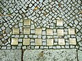
Nassauische Strasse 30

Stumbling block for the opera singer Therese Rothauser in Konstanzer Straße 11

Nassauische Strasse 54
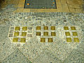
Güntzelstrasse 49

_Therese_Rothauser.jpg)


Personalities

- Paul Abraham (1892–1960), composer (including Ball im Savoy) , lived at Fasanenstrasse 33 from 1930–1933 until he was forced to leave Germany as a result of the “ seizure of power ” by the National Socialists due to his Jewish origins.
- Dagmar Altrichter (1924–2010), actress and voice actress.
- Cora Berliner (1890–1942), economist and social scientist and victim of the Holocaust ; lived in Wilmersdorf.
- Hildegard Böhme (1884–1943), teacher and provincial welfare officer and victim of the Holocaust; lived in Wilmersdorf
- Bertolt Brecht (1898–1956), poet and playwright, lived with Helene Weigel (1900–1971) at Spichernstrasse 16 from 1929 until they emigrated to the USA in 1933. This is where the text for his Threepenny Opera was written .
- Ernst Busch (1900–1980), actor, lived in the artists' colony from 1929 onwards . There he narrowly escaped arrest during the first raids in 1933, only to be able to flee Germany shortly afterwards. After the war he moved to the GDR , where he enjoyed great success as an actor, so that in 1981 the renowned state academy for drama "Ernst Busch" in East Berlin was renamed in his honor.
- Walter Caro (1899–1944), resistance fighter against National Socialism .
- Dirk Cornelsen (* 1940), journalist and publicist, grew up with his aunt, the graphic artist Hildegard Cornelsen and her husband, the schoolbook publisher Frank Cornelsen, in the artists' colony at Laubenheimer Straße 23
- Marlene Dietrich (1901–1992), film actress and chanson singer, lived with her mother from 1914 at Kaiserallee 219/220 (today: Bundesallee 220), from 1917 at Kaiserallee 135 ( Friedenau ). After marrying Rudolf Sieber in 1923, the couple moved into an apartment at Kaiserallee 17, and after their daughter Maria was born in 1924, they moved into an apartment at Kaiserallee 54 (today: Bundesallee 54). The apartment remained the joint registration address of the couple until Sieber followed his wife and their daughter to the USA in 1933 as a result of Hitler's " seizure of power " .
- Gerhard Krüger (1902–1972), philosopher and cultural scientist born in Wilmersdorf.
- Karl Ernst (1904-1934), politician ( NSDAP ) and group leader of the SA , and from 1932 to 1934 Reichstag deputy and from 1933 until his death a member of the Prussian State Council .
- Fritz Fliegel (1907–1941), fighter pilot, cyclist and knight's cross holder, crashed over the Atlantic in 1941.
-
Birger Forell (1893–1958), Swedish theologian, was pastor of the Swedish community in Berlin from 1929 to 1942, supported persecution of the Nazi regime until the National Socialists forced him to leave Berlin.
 Memorial plaque on Birger-Forell-Platz
 - Gerhard Goldschlag (1889–1944), conductor, composer and journalist as well as a victim of the Holocaust
- Brigitte Helm (1906–1996), actress, a. a. known from the silent film Metropolis , lived at times at Barneyweg 5 in the artists' colony.
- Dörte Helm-Heise (1898–1941), Bauhaus student, painter and graphic artist, who was born in Wilmersdorf.
- Hans-Jürgen Hellriegel (1917–1944), naval officer and submarine commander in World War II.
- Erich Kästner (1899–1974), writer and publicist, lived on Prager Strasse from 1927–1931 . There was u. a. the youth novel Emil and the detectives .
- Hildegard Knef (1925–2002), actress, chanson singer and book author, lived near Prager Platz in the 1990s after her return from the USA .
- Rudolf Koch (1909–1963), forensic doctor and university professor, was born in Wilmersdorf.
- Walter Küchenmeister (1897–1943), iron turner, journalist, editor and writer as well as resistance fighter (Rote Kapelle) in the Third Reich, lived in Sächsische Straße 63a
- Margo Lion (1899–1989), actress and Diseuse, lived at Rüdesheimer Platz 10 in the Rheingauviertel from 1931–1933
- Ellinor Michel (1939–2007), graphic artist and painter
- Elisabeth Pungs (1896–1945), resistance fighter , lived at Wiesbadener Strasse 45 from 1936
-
Erich Maria Remarque (1898–1970), writer, lived at Wittelsbacher Strasse 5 until 1929. There, among other things, his novel In the West, nothing new was written .
 Memorial plaque for Erich Maria Remarque in Wittelsbacher Strasse 5
 - Therese Rothauser (1865–1943), opera singer and victim of the Shoah , lived at Konstanzer Straße 11. Before the First World War she sang on several major German theaters and was given a personal gift by Kaiser Wilhelm II , a precious sapphire brooch , for her talent , honored. She then worked in Berlin as a singing teacher. In 1942 she was deported to Theresienstadt , where she died a few months later.
- Augustin Souchy (1892–1984), anarchist and anti-militarist, lived on the fourth floor of Augustastraße 62 and gave shelter to the Spanish anarchist Buenaventura Durruti for several weeks.
- Heinrich Mann (1871–1950), writer and brother of Thomas Mann , lived at Fasanenstrasse 61 from 1932 to 1933 until he emigrated to France and then to California shortly after the Reichstag fire .
-
Maria Countess von Maltzan (1909–1997) was a resistance fighter, veterinarian and author. In her Wilmersdorf apartment she hid three Jewish friends who were friends , sometimes for days in their bed boxes, from the Gestapo . She also supported Birger Forell in helping Jewish citizens to escape, including the "Aktion Schwedenmöbel", in which pieces of furniture were sent to Sweden in which the persecuted were hiding. In the courtyard of her house, she set up a soup kitchen for slave laborers until she was bombed out in the final weeks of the Second World War . The State of Israel awarded her the title of ' Righteous Among the Nations ' after the war . It can be assumed that she was instrumental in the rescue of over 60 politically or racially persecuted people.
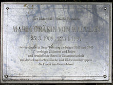 Memorial plaque for Maria Countess von Maltzan in Detmolder Straße 11
 - Asta Nielsen (1881–1972), Danish actress who enjoyed great success at UFA during the silent film era . From 1927 to 1932 she lived at Kaiserallee (today: Bundesallee) 202.
- Steffie Spira (1908–1995), actress, lived at Bonner Strasse 9.
- Alexander Graf Stenbock-Fermor (1902–1972), writer and resistance fighter, lived and worked under the pseudonym Peter Lorenz in the artists' colony.
_Birger_Forell.jpg)

_Maria_Gr%C3%A4fin_von_Maltzan.JPG)
See also
Detailed articles on Wilmersdorf:
- List of streets and squares in Berlin-Wilmersdorf
- List of cultural monuments in Berlin-Wilmersdorf
- List of stumbling blocks in Berlin-Wilmersdorf
- Wilmersdorfer widows
literature
- Paul Wollschläger: Wilmersdorf in old and new times. Berlin 1968.
- Udo Christoffel (Ed.): Berlin Wilmersdorf - A city part book. Wilmersdorf Art Office, Berlin 1981.
- Udo Christoffel (Ed.): Berlin Wilmersdorf - Wilmersdorf, Schmargendorf, Kolonie and Forst Grunewald depicted in the map for the years from 1588 to 1938. Wilmersdorf Art Office, Berlin 1983.
- Udo Christoffel (Ed.): Berlin Wilmersdorf - In StadtAnsichten. Wilmersdorf Art Office, Berlin 1984.
- Udo Christoffel (Ed.): Berlin Wilmersdorf - The years 1920 to 1945. Wilhelm Möller, Berlin 1985, ISBN 3-9801001-1-1 .
- Rolf Lieberknecht, Karl-Heinz Metzger a. a .: From the Wilhelmsaue to the Carstenn figure . 120 years of urban development in Wilmersdorf. District Office Wilmersdorf of Berlin, Berlin 1987.
- Karl-Heinz Metzger: Wilmersdorf in the mirror of literary texts from the 19th century to 1933. Wilmersdorf district office of Berlin, Berlin 1985.
- Karl-Heinz Metzger: Churches, mosques and synagogues in Wilmersdorf. District Office Wilmersdorf of Berlin, Berlin 1986.
- Karl-Heinz Metzger, Ulrich Dunker: The Kurfürstendamm - the life and myth of the boulevard in 100 years of German history. District Office Wilmersdorf of Berlin, Berlin 1986, ISBN 3-924812-13-6 .
- Lilli Moritz: The village school in Wilmersdorf. Part II: 1855-1886. In: Yearbook Der Bär von Berlin . Association for the History of Berlin , 13th year, Berlin 1964.
- Udo Christoffel (Ed.): Berlin Wilmersdorf - The Jews - Life and Suffering. Wilmersdorf Art Office, Berlin 1987.
- Hans-Ulrich Kamke, Sigrid Stöckel, Wolfgang Ribbe (Eds.): Wilmersdorf. History of the Berlin administrative districts. Volume 11. Colloquium Verlag, Berlin 1989, ISBN 3-7678-0721-1 (published by the Historical Commission in Berlin).
- Felicitas Bothe-von Richthofen: Resistance in Wilmersdorf. Berlin 1993, ISBN 3-926082-03-8 (from the series Resistance 1933–1945 of the German Resistance Memorial Center Berlin).
- Udo Christoffel, Elke von der Lieth (ed.): Berlin-Wilmersdorf - Persecution and Resistance 1933 to 1945. Wilmersdorf district office of Berlin, Willmuth Arenhövel publisher, Berlin 1996, ISBN 3-922912-39-7 .
- Working group history Wilmersdorf (Hrsg.): Fragments - Wilmersdorf. OMNIS Verlag, Berlin 1998, ISBN 3-933175-55-0 .
- Christian Simon: Wilmersdorf - between idyll and metropolis. be.bra verlag, Berlin 2015, ISBN 978-3-8148-0210-7 .
Web links
- An overview of Wilmersdorf's history. District Charlottenburg-Wilmersdorf
- Wilmersdorf in old views
Individual evidence
- ↑ Habermannplatz. In: Street name lexicon of the Luisenstädtischer Bildungsverein (near Kaupert )
- ↑ Berliner Geschichtswerkstatt puts a provisional memorial plaque on Wilhelmsaue 40
- ↑ Mayor and District Mayor
- ↑ Big city faces from Fasanenplatz. Retrieved December 13, 2017 .
- ↑ For strollers and connoisseurs: Ludwigkirchplatz in Wilmersdorf. In: qiez.de. Retrieved August 10, 2016 .
- ↑ Eve-Catherine Trieba: The Güntzelkiez in Wilmersdorf is one of the most beautiful quarters in Berlin for us. Retrieved March 9, 2017 .
- ↑ Favorite Streets in 12 European Cities . In: The New York Times . April 16, 2015, ISSN 0362-4331 ( nytimes.com [accessed August 10, 2016]).
- ↑ Alexander Stenbock-Fermor: The red count. Baltic aristocrat, White Guard, miner, resistance fighter, writer. 2nd Edition. Verlag der Nation, Berlin 1975, p. 312 ff .
- ↑ Marlene in Berlin | Deutsche Kinemathek - Museum for Film and Television. In: deutsche-kinemathek.de. Retrieved August 9, 2016 .
- ^ Prager Platz in Berlin Wilmersdorf. Sightseeing Berlin. Tourist information Berlin Wilmersdorf. In: sehenswuerdheiten-berlin.de. Retrieved August 9, 2016 .
- ↑ Kulturring in Berlin e. V .: Culture Guide-Berlin. In: Kulturfuehrer-berlin.de. Retrieved August 9, 2016 .
- ↑ Hans Magnus Enzensberger: The short summer of anarchy (1977), p. 75