
Hohenzollerndamm
| Hohenzollerndamm | |
|---|---|
|
|
|
 |
|
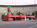
| The Hohenzollerndamm near Fehrbelliner Platz |
|
| Basic data | |
| place | Berlin |
| District |
Wilmersdorf , Schmargendorf , Grunewald |
| Created | 1875 |
| Connecting roads |
Nachodstrasse (east) , Clayallee (southwest) |
| Cross streets |
(Selection) Bundesallee , Uhlandstrasse , Brandenburgische Strasse , Konstanzer Strasse , Forckenbeckstrasse , Rheinbabenallee |
| Places |
Hohenzollernplatz , Fehrbelliner Platz , Hoffmann-von-Fallersleben-Platz , Flinsberger Platz , Elsterplatz , Roseneck |
| Buildings | see: Sights |
| use | |
| User groups | Pedestrian traffic , bicycle traffic , car traffic , public transport |
| Technical specifications | |
| Street length | 4480 meters |


The Hohenzollerndamm is an important main road in the Berlin districts of Wilmersdorf , Schmargendorf and Grunewald , which connects the western city center with the southwestern district of Steglitz-Zehlendorf . The street was laid out around 1875 and was given its current name around 1900 in honor of the family of the Hohenzollerns who made up the Prussian kings and German emperors until 1918 .
course
The Hohenzollerndamm begins in the western inner city of Berlin , in the middle of the historic Carstenn figure , on Bundesallee in the area of the Spichernstrasse underground station and runs out of town in a south-westerly direction via Hohenzollernplatz and Fehrbelliner Platz . In this section, the U3 underground line runs under the street. Fehrbelliner Platz is surrounded by administrative buildings from the 1920s and the National Socialist era , such as the Wilmersdorf Town Hall, and the building for the German Pension Insurance from the 1970s and the Prussian Park . Further to the south-west is Hoffmann-von-Fallersleben-Platz with the Russian Orthodox Christ Resurrection Cathedral , inaugurated in 1938 , which, as the main church of this religious community in Germany , was supposed to win over the anti-Soviet group. The Hohenzollerndamm then crosses the Berlin Ringbahn with the Hohenzollerndamm S-Bahn station and the A 100 city motorway . The border between the districts of Wilmersdorf and Schmargendorf is also located here. From now on, Hohenzollerndamm continues in a south-westerly direction, initially along the extensive building complex of the former military district command III of the Wehrmacht , which was taken over by the AEG after 1948 as a Berlin branch .
At the confluence of Salzbrunner Straße is the Evangelical Gymnasium Zum Grauen Kloster, the oldest grammar school in Berlin, which had been located in Berlin-Mitte as the Berlinisches Gymnasium zum Grauen Kloster since 1574 and was reopened here after the Second World War .
The Hohenzollerndamm leads past Flinsberger Platz and Elsterplatz - where it crosses Berkaer Straße near the town hall Schmargendorf - past to Roseneck , where Teplitzer Straße and Rheinbabenallee merge into Hohenzollerndamm. The street that continues in a straight line bears his name - now in the district of Grunewald - for another 250 meters and turns in a clear left curve at the confluence of Bernadottestraße into Clayallee leading to Zehlendorf and Teltow .
Originally, around 1900, the Hohenzollerndamm ran on a slightly different route just outside the Ringbahn near the Grunewald near today's Clayallee . In 1908, the Preußische Strasse within the S-Bahn ring - whose name was in connection with the Bavarian , Pomeranian , Sächsische , Württembergische Strasse and the Preußenpark - was renamed to match the existing Hohenzollernplatz and under this name to what was then Kaiserallee (today: Bundesallee ) connected. As a result, the sections were merged into a representative street.
The western Berlin suburban railway opened the tram route from the corner of Berliner Straße to Roseneck on February 27, 1913 . The eastern part of Hohenzollerndamm between Berliner Straße and Güntzelstraße was used by the Great Berlin Tram from February 25, 1917 , which also took over the section to Roseneck from that day. Most recently, the tram line 57 of the Berliner Verkehrsbetriebe (BVG) ran on the Hohenzollerndamm between Emser Platz and Roseneck, it was discontinued on November 1, 1954 and replaced by the A50 bus line (now 115).
Architectural mile Hohenzollerndamm
The Hohenzollerndamm is lined with some significant architectural monuments from the 20th century. Starting in the northeast these are:
- Old pumping station of the Berliner Wasserbetriebe , Hohenzollerndamm 208, built by Hermann Müller in the form of the Brandenburg brick Gothic 1905/1906. Next to it, a new building made of glass and steel by Kurt Ackermann , built 1991–1998.
- Evangelical Church on Hohenzollernplatz , built 1931–1932 by Fritz Höger in the form of North German brick expressionism .
- Underground stations on the U3 line : Hohenzollernplatz and Fehrbelliner Platz , opened in 1913.
- Fehrbelliner Platz underground station on the U7 line and above-ground structure, built in the 1970s in a deliberate contrast to the official buildings surrounding the square.
- Fehrbelliner Platz building ensemble with administrative buildings from the 1930s and 1940s, such as the former Wilmersdorf Town Hall from 1941 to 1943 and the building of the Senate Department for the Interior and the headquarters of the German Pension Insurance from 1970 to 1973.
- Apartment house Hohenzollerndamm 35/36 from the years 1929/1930 by Hans Scharoun and Georg Jacobowitz .
- Russian Orthodox Cathedral of the Resurrection of Christ , Hohenzollerndamm 166, built in 1937/1938 by Karl Schellberg as a replacement for the previous church at Hohenzollerndamm 33.
- Office tower of the Deutsche Rentenversicherung , Hohenzollerndamm 47, 100 meters high, 23 storeys, built 1973–1977 by Hans Schäfers and Hans Jürgen Löffler
- Hohenzollerndamm S-Bahn station , built 1908–1910 in neo-baroque and art nouveau styles by Heinrich Thiesing.
- Building of the former military district command III of the Wehrmacht , Hohenzollerndamm 150–152, built by Rudolf Klar in 1936–1943 .
- Evangelical Kreuzkirche , Hohenzollerndamm 130, built 1927–1929 by Ernst and Günther Paulus in expressionist brick architecture .
- High- rise residential building on Roseneck , Hohenzollerndamm 105–110, 15-storey urban planning dominant in the characteristic shape of the 1950s, built in 1954/1955 by Franz-Heinrich Sobotka and Gustav Müller.

Hohenzollerndamm S-Bahn station , reception building

Old pumping station Hohenzollerndamm 208

New pumping station at Hohenzollerndamm 208

Hohenzollerndamm 150–152

Evangelical Church on Hohenzollernplatz

Russian Orthodox Christ Resurrection Cathedral

Hohenzollerndamm 33, former Russian Orthodox cathedral, built 1923–1928, rebuilt in 1938

Hohenzollerndamm 35/36 (by Hans Scharoun and Georg Jacobowitz)
Entrance building of the Fehrbelliner Platz underground station

Former Wilmersdorf town hall

The Seven Swabians in front of the former Karstadt administration building

High-rise residential building on the Roseneck

Office tower of the Deutsche Rentenversicherung , Hohenzollerndamm 47


Web links
-
Hohenzollerndamm. In: Street name lexicon of the Luisenstädtischer Bildungsverein (near Kaupert )
- Reissnerstrasse . In: Luise.
- Prussian street . In: Luise.
Individual evidence
- ↑ [1]
- ↑ The Gray Monastery after the Second World War
- ^ Christian Winck: The tram in the Charlottenburg-Wilmersdorf district . VBN Verlag B. Neddermeyer, Berlin 2015, ISBN 978-3-933254-30-6 , pp. 31 .
- ^ Christian Winck: The tram in the Charlottenburg-Wilmersdorf district . VBN Verlag B. Neddermeyer, Berlin 2015, ISBN 978-3-933254-30-6 , pp. 55 .
- ^ Christian Winck: The tram in the Charlottenburg-Wilmersdorf district . VBN Verlag B. Neddermeyer, Berlin 2015, ISBN 978-3-933254-30-6 , pp. 172 .
- ↑ [2]
- ↑ [3]
- ↑ [4]
- ↑ [5]
- ↑ [6]
- ↑ [7]
- ↑ [8]
- ↑ [9]
Coordinates: 52 ° 29 ′ 17.8 ″ N , 13 ° 18 ′ 19.9 ″ E