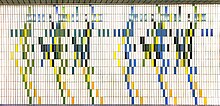
Spichernstrasse underground station

The Spichernstraße is a transfer station of the Berlin U-Bahn -lines U9 and U3 in the district of Wilmersdorf of the district Charlottenburg-Wilmersdorf . It was opened for the U3 line on June 2, 1959 and for the U9 line on August 28, 1961.
In the station directory of the Berliner Verkehrsbetriebe , the station has the names Sno (U3 / above) and Snu (U9 / below).
location
The platform of the U9 line is under Bundesallee , the two side platforms of the U3 line are under Spichernstrasse .
Although the station has escalators , it is currently not barrier-free . As early as 2009, the BVG announced that both the platform of the U3 and the U9 should have an elevator in the period from 2011 to 2013. In fact, the first elevator from the U3 platform (in the direction of Wittenbergplatz) to the surface did not go into operation until spring 2020. The second elevator to the other U3 platform and to that of the U9 is expected to follow in September this year.
Naming
The underground station is named after the adjacent Spichernstrasse, which in turn is named after the Spicherer Heights, a ridge in the central Saar valley south of Saarbrücken near the Lorraine village of Spichern , which was stormed on August 6, 1870 by troops of the North German Confederation during the battle cleared the way to Metz at Spichern in the Franco-Prussian War and ultimately enabled the establishment of the German Empire with the victory over France .
U9 station

The station on the U9 line - opened as Spichernstrasse (Bundesallee) - has, like all stations on the former G line, an 8.85-meter-wide central platform . There are entrances at both ends of the platform: One on Joachimsthaler Straße , the southern one leads via a vestibule and aisle system to the two side platforms of the U3. The walls were light blue at the time of opening, the hexagonal pillars were painted dark blue. Gray tiles and small mosaics in the colors pink and white as well as dark blue supports were used in the vestibules . The station designed by Bruno Grimmek is therefore a standard station on the former G.
From 1961 to 1971 this station was a terminus, but had no sweeping tracks . Therefore, the trains ended up at the platform. To make this possible, there was a double track change in front of the station , which was removed when the track was renewed in the 1980s.
In 1986/1987 new wall tiles were installed. According to the plans of Gabriele Stirl, white tiles with colored patterns were installed, which form the score of a piece of music and thus provide a reference to the Joachimsthalsche Gymnasium near the train station , which is largely used by the music department of the University of the Arts .
U3 station
In order to make it possible to change from the former lines A II / B II (today: U3) to the then newly built line G (today: U9), two side platforms were built. Since the Nürnberger Platz underground station at that time was very close, it was closed on June 2, 1959 and the Augsburger Strasse underground station was rebuilt as a replacement . The construction was relatively easy to realize, as in the area of today's station there was previously a double-track sweeping track that belonged to the Nürnberger Platz station. The train traffic was routed over the sweeping tracks, the old tracks were removed and two side platforms were built in their place.
The station got entrances at both ends of the platform. The southern area was designed more extensively, as the transition to the U9 line was also built there. In order to enable passengers on the eastern side platform to change trains underground, a pedestrian tunnel was created under the tracks that connects the side platforms with one another.
Connection
At the underground station you can change between lines U3 and U9 as well as to bus line 204 of the BVG .
Web links
Individual evidence
- ↑ Elevator Program of the Berlin Senate, prioritized list of 2009 (PDF, 89 kB), Senate Department for Urban Development, June 9, 2009
- ^ First elevator at Spichernstrasse subway station . In: BVG plus . No. 6 , 2020, p. 4 .
- ↑ a b c d Description of the Spichernstrasse underground station on the U9 at berliner-untergrundbahn.de ( memento of the original dated June 11, 2010 in the Internet Archive ) Info: The archive link was automatically inserted and not yet checked. Please check the original and archive link according to the instructions and then remove this notice.
- ↑ a b Description of the Spichernstrasse underground station on the U3 at berliner-untergrundbahn.de ( memento of the original from April 13, 2010 in the Internet Archive ) Info: The archive link was inserted automatically and has not yet been checked. Please check the original and archive link according to the instructions and then remove this notice.
Coordinates: 52 ° 29 ′ 47.2 " N , 13 ° 19 ′ 50.5" E

