
Kottbusser Tor underground station
.JPG)

The kottbusser tor is located in the Berlin district of Kreuzberg the district of Friedrichshain-Kreuzberg . As the crossing station of the underground lines U1 / U3 and U8, it is located within the plaza of the same name above (U1 / U3) and below (U8) street level. Its internal BVG names are Kbo (U1 / U3, above) and Kbu (U8, below).
The distances to the neighboring stations are 650 meters to the east ( Görlitzer Bahnhof ) and 900 meters to the west ( Prinzenstraße ) on the elevated railway line , 860 meters to the north ( Moritzplatz ) and 670 meters to the south ( Schönleinstraße ) underground .
history


.jpg)
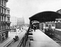
The original elevated station was put into operation on February 15, 1902 under the name Kottbuser Thor east of the square. With its side platforms, it was largely similar to the neighboring Görlitzer Bahnhof station. It was located on the city's first underground line, also known as the "main line", which was largely designed as an elevated railway and is designated in this section with the letter "B".
In connection with the opening of the underground station of the GN-Bahn (Gesundbrunnen-Neuköllner-Bahn, formerly line D , today's line U8) on February 12, 1928, the old elevated station was replaced by the now known and listed building directly above the square from 1927 and Opened to traffic on August 4, 1929 together with the Leinestrasse subway station . At the site of the former, eastern high station, a parking and sweeping track was applied between the track rails on which the days of the Berlin Wall in the rush hour of Theodor-Heuss-Platz spent coming amplifier units.
The Kottbusser Tor underground station was initially the terminus for trains coming from the Boddinstraße underground station until April 6, 1928 . On that day the traffic to Neanderstraße (today: Heinrich-Heine-Straße ) was started and the station to the through station.
Since the introduction of the line numbers on March 1, 1966, line 1, which has been referred to as U1 since 1984, and temporarily the U12 and U15 have operated on the elevated railway station.
Building

The underground station is at level −1.5, it is slightly curved. Deviating from the original plan, which provided for a straight route through Dresdener Straße, it was carried out from Kottbusser Straße to the northern Reichenberger Straße. Above, below street level, there is a distribution level with a counter hall and four entrances from the surrounding sidewalks. Accesses were also built to the ends of the underground platform.
Today's high station received a 110 meter long and 11 meter wide central platform . The construction work took place "under the wheel", that is, without stopping the current traffic. The bridge construction has an extraordinary span of 52.5 meters between the pillars. In contrast to the rest of the route, silicon steel (St. Si) was used for the substructure of the station hall because of the wide main girders. At both ends of the platform there are stairs to street level below the elevated railway line. Another staircase and two escalators connect the elevated platform with the distribution level right from the start.
Overcoming the height difference of 13.8 meters between the elevated and the underground platform is nowadays also possible with an elevator system - and therefore barrier-free .
For some time now, the station and the surrounding area have been upgraded and repaired through extensive work, but this has not yet happened.
Connection
The underground station serves as a transfer point between the underground lines U1, U3 and U8 as well as the bus line 140 of the Berliner Verkehrsbetriebe.
The first Kottbusser Tor station had side platforms, 1904

South central support of the elevated station, behind the stairs to the underground station, 1992

Platform of the U1, the destination indicator is still labeled as Line 1 in 1992

Elevated platform of the U1, on the left an A3L train , 2000


Web links
Individual evidence
- ^ Jürgen Meyer-Kronthaler: Berlin's subway stations - the first hundred years. be.bra Verlag, Berlin 1996, p. 151, ISBN 3-930863-16-2
- ^ Ulrich Lemke, Uwe Poppel: Berlin U-Bahn . 3. Edition. Alba, Düsseldorf 1992, ISBN 3-87094-346-7 , pp. 45 f .
- ↑ Alfred Gottwaldt: The Berlin U- and S-Bahn network . 1st edition. Argon, Berlin 1994, ISBN 3-87024-284-1 , p. 54 .
- ↑ EhJ Bousset: The Berlin U-Bahn , p. 106
- ↑ a b E.h. J. Bousset, op. Cit. , P. 107
- ↑ EhJ Bousset, op. Cit. , P. 36 f
- ↑ Reconstruction at Kottbusser Tor is delayed . In: Der Tagesspiegel , accessed on May 6, 2013
Coordinates: 52 ° 29 ′ 57 ″ N , 13 ° 25 ′ 5 ″ E