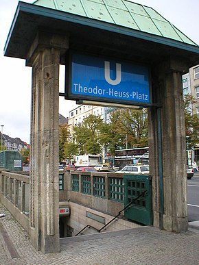
Theodor-Heuss-Platz underground station
The Theodor-Heuss-Platz U-Bahn station is a station on the U2 line of the Berlin U-Bahn . It is located under Theodor-Heuss-Platz in the Westend part of Berlin's Charlottenburg-Wilmersdorf district and was opened on March 29, 1908 under the name Reichskanzlerplatz .
history
At the beginning of the 20th century, the then independent city of Charlottenburg planned to build on the still undeveloped area in the west, which consequently received the name Westend . Since the elevated and underground railroad coming from the east was already running to the knee - today's Ernst-Reuter-Platz - it turned out to be beneficial to use the underground railway to develop the as yet undeveloped area. The city of Charlottenburg signed a contract with the operating elevated railway company on June 23, 1906. In the first years of operation - various reports have been made, even up to 1931 - the elevated railway company received large subsidies for the route that was not yet profitable.
The elevated railway company had the three stations Sophie-Charlotte-Platz , Kaiserdamm and Reichskanzlerplatz built for the new route . The Bismarckstrasse station (today: Deutsche Oper ) had to be rescheduled later, as the line to Reichskanzlerplatz was added to the line to Wilhelmplatz (today: Richard-Wagner-Platz ) that was already under construction .

The Reichskanzlerplatz underground station received two 114.4 meter long side platforms that are not connected to each other, so that you can only get from one platform to the other above ground. The portal-like entrances are on the northeast side of the square. The in-house architect of the elevated railway company, Alfred Grenander , designed the station with colored ceramic tiles , Grenander particularly emphasized the formerly only exit in the direction of Pankow , which was decorated with ceramics from the royal majolica workshops made of Cadinen . To the west of the station there is a double-track sweeping system .
The station was opened with the line Bismarckstrasse - Reichskanzlerplatz on March 29, 1908. Two weeks earlier, on March 14, Kaiser Wilhelm II traveled the line on the so-called "Kaiserfahrt". Initially the line ended here and only ran to Bismarckstrasse (today: Deutsche Oper ). For the opening of the German Stadium in 1913, the U-Bahn line was extended beyond the Reichskanzlerplatz to the newly built Stadion station and in 1929 to the present end point in Ruhleben .
After the " seizure of power " by the National Socialists in 1933, the station was named Adolf-Hitler-Platz, just like the square . In connection with the planning for the " World Capital Germania ", the station was to be completely rebuilt. For example, a four-track train station was to be built on the south side of the square, from which another subway line was to emerge to the west, which was to lead to Pichelsdorf and Gatow through the planned university town. Although some preliminary work was done for this development from 1939 onwards, it was never actually implemented.

During the Second World War , the station was one of the few in the Berlin subway network to suffer hardly any damage, at least no bomb hits are documented. A shuttle service between Kaiserdamm and Ruhleben was able to commence on May 17, 1945, and the station was given its original name Reichskanzlerplatz back. From September 15, 1946, the trains on line A I ran again on the full route between Ruhleben and Pankow.
Six days after the death of the first Federal President Theodor Heuss , the above-ground square and the underground station were given their current name on December 18, 1963. For the 750th anniversary of Berlin , the BVG had the station completely renovated, including the gray tiles on the station walls.
In West Berlin , an extension of today's U1 line was always planned. It was to be extended from the Uhlandstrasse underground station via Theodor-Heuss-Platz along Heerstrasse to Spandau . Even these plans - in this dimension - are no longer valid today, even if the route to Theodor-Heuss-Platz is still kept clear and there is an advance construction work at the intersection of Neue Kantstrasse , Masurenallee and Messedamm.
Due to a fire in the Deutsche Oper underground station on July 8, 2000, the BVG decided to build another in all underground stations with only one exit. This includes the Theodor-Heuss-Platz train station, which has had an exit on the platform in the direction of Ruhleben since May 15, 2006, and there is also a new elevator system right next to it, but both only in the direction of Ruhleben. The BVG opened a second exit to the east on July 27, 2007, construction work began on August 22, 2006, the costs totaled 650,000 euros. A second elevator on the platform in the direction of Pankow has been in operation since June 24, 2010. This means that the station is completely barrier-free .
Connection
At the underground station you can change from the U2 line to the M49, X34, X49, 104, 218 and 349 bus lines operated by Berliner Verkehrsbetriebe.
Web links
- BVG map of the train station (PDF; 251 kB)
- Description of the route Bismarckstraße - Ruhleben including pictures of the train station
- More pictures at untergrundbahn.de
- Entry in the Berlin State Monument List
Individual evidence
- ^ U-Bahn: Reichskanzlerplatz - Gatow . From: forst-grunewald.de , accessed on December 29, 2017
- ^ Fire in the Deutsche Oper underground station ( memento from June 3, 2010 in the Internet Archive ) at www.bestpractice-feuerwehr.de
- ↑ Press release of the Berliner Verkehrsbetriebe, May 23, 2006
- ↑ Press release of the Berliner Verkehrsbetriebe, June 24, 2010
Coordinates: 52 ° 30 ′ 35 ″ N , 13 ° 16 ′ 23 ″ E
