New Kantstrasse
| New Kantstrasse | |
|---|---|
| Street in Berlin | |
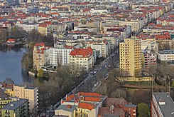
| Neue Kantstraße, left the Lietzensee | |
| Basic data | |
| place | Berlin |
| District | Charlottenburg |
| Created | 1905 |
| Hist. Names | Street 9d |
| Connecting roads | Kantstrasse (east) , Masurenallee (west) |
| Cross streets | Suarezstrasse, Trendelenburgstrasse, Lietzenseeufer, Kuno-Fischer-Strasse, Herbartstrasse, Wundtstrasse, Dernburgstrasse, Spiegelweg, Messedamm |
| Places | District Court Place |
| Buildings | International Congress Center (ICC) |
| use | |
| User groups | Pedestrian traffic , bicycle traffic , car traffic , public transport |
| Technical specifications | |
| Street length | 1000 meters |
The Neuekantstrasse is about one kilometer long road between the districts of Charlottenburg and Westend of Berlin district of Charlottenburg-Wilmersdorf . It runs from Suarezstraße at the Amtsgerichtsplatz over the East Prussia Bridge to Messedamm, where it turns into Masurenallee . As an extension of the Kantstrasse coming from Breitscheidplatz , it was named on August 27, 1905 after the philosopher Immanuel Kant . On October 20, 1966, the section of Masurenallee from the East Prussia Bridge to the Messedamm was also renamed Neue Kantstrasse. The original name of the development plan at that time (Section V / 3) was Straße 9d . As the main thoroughfare , Neue Kantstrasse and Kantstrasse connect City-West with the radio tower and the exhibition grounds .

Approximately half its length, the Neuekantstrasse crossed with Lietz pier the Lietzensee . Since 1904, the lake has been divided by a dam that was built up for Neue Kantstrasse, which divides the lake into a north and a south half. Both parts have been connected by an underpass since 1954 .
The Prussia bridge at the western end of the new Kantstrasse spans over a length of approximately 200 meters, the annular track and extending parallel thereto lanes of the city ring , here in the area around the motorway triangle radio tower having the highest traffic density of all motorway sections Germany. On the northern side of the bridge is the entrance to the S-Bahn station Messe Nord / ICC, which was opened to traffic on April 1, 1916 . Immediately at the end of the street is the International Congress Center (ICC) to the south and the Central Bus Station on the diagonally opposite side .
Web links
- New Kantstrasse. In: Street name lexicon of the Luisenstädtischer Bildungsverein (near Kaupert )
Coordinates: 52 ° 30 ′ 23 ″ N , 13 ° 17 ′ 1 ″ E

