
East Prussia Bridge
Coordinates: 52 ° 30 ′ 23 ″ N , 13 ° 16 ′ 55 ″ E
| East Prussia Bridge | ||
|---|---|---|
 |
||
| Convicted | New Kantstrasse | |
| Subjugated | City ring , circular railway | |
| place |
Charlottenburg (O) Westend (W) |
|
| Entertained by |
Senate Department for Urban Development DB Station & Service AG |
|
| Building number | 07371-0010 | |
| construction |
Beam bridge Prestressed concrete bridge |
|
| overall length | 93 m | |
| width | 38 m | |
| Number of openings | three (between V-pillars) A 100-West Ringbahn Autobahn-Ost |
|
| Clear width | 53 m (via train) | |
| Clear height | over 6.5 m | |
| vehicles per day |
8,000 trucks 33,300 vehicles |
|
| completion | 1960 | |
| location | ||
|
||
| Above sea level | 46 m | |

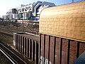
The East Prussia Bridge is a 93 meter long prestressed concrete bridge in the Berlin district of Charlottenburg-Wilmersdorf . It leads the Neue Kantstraße over the Ringbahn and the city motorway and thus connects the districts of Berlin-Charlottenburg and Westend . In 1960, it replaced the previous bridge from 1915.
location


.jpg)

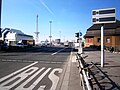
Neue Kantstrasse is led over the bridge, at the western end is the International Congress Center Berlin (ICC) in the immediate vicinity . To the east of the bridge ( 45.1 m ), Neue Kantstrasse continues with property 17 at the Wundtstrasse / Dernburgstrasse intersection and with numbers 16, 15 (north side) and 18–20 (continuous) over Herbartstrasse with the heaped headland in Lietzensee to the Lietzenseebrücke. At the west end, Neue Kantstrasse leads over the intersection of Messedamm ( 49.7 m ) and the route into Masurenallee . The bridge rises to the west by almost three meters. Under the bridge are the directional lanes of the city motorway on both sides of the original railway site. In the middle are the two direction tracks for the S-Bahn on the platform and two tracks for long-distance, regional and freight traffic. A special feature of the bridge is the border between the districts of Charlottenburg / Westend. This is on the lane above between the western lane of the A 100 and the track body; 30 meters of the bridge support belong to Westend. Both districts administratively belong to the same district. Due to the suburbs, the bridge is in two postcode areas: 14057 for Charlottenburg and 14052 for Westend.
In 2014, 33,300 vehicles, 8,000 of them trucks, drove over the bridge every day. S-Bahn traffic (lines S41 , S42 , S46 ) and rail traffic on the two other tracks are under it. 191,500 vehicles pass through the A 100 every day, 121,700 of which were counted as trucks. The transferred Neue Kantstraße is one of the higher-level road connections in Berlin and the underpassed federal motorway 100 is one of the large-scale road connections . The railway administration is also responsible due to the railway cut.
From bus traffic on the bridge, the express lines X49 ( Spandau / Hahneberg - S Messe-Nord / ICC), X34 ( Kladow - Zoo ), the MetroBus M49 (Spandau / Heerstraße - Zoo) and line 139 ( Hakenfelde - S Messe Nord) connected with the S-Bahn. With the construction of the station entrance on the south side, bus lanes were created in 2009 and the bus stops expanded. There is a parking lot at the northwest corner of the bridge , under which the exit from the ICC (via the entrance and exit of ASt Kaiserdamm Süd) leads to Messedamm.
The East Prussia Bridge is a "city road bridge over the BAB" with an area of 3359 m² in a "List for buildings (partial structures) in the course of / over / adjacent to federal highways" in the responsibility of the Senate Department for Urban Development and the Environment, Berlin (status: 2015) added under the building number 3445031 with the (construction) condition class 3.0-3.4 (medium). In the street cleaning directory A, the bridge belongs to cleaning class 1b.
design type
The slab bridge has a 38 meter wide superstructure with four lanes to the west (11.5 meters) and three lanes to the east. Both lanes are separated by a 2.6 meter wide median at sidewalk height, on which there is a separating grille. On both sides are wide sidewalks , at the eastern end of the bridge - the intersection Wundtstraße - there is the crossing . The two outer lanes on the bridge are designed as bus lanes. The two bus stops at the station exit were designed with the creation of the southern S-Bahn access in 2009. The cycle path marked on the north side is on the sidewalk around the bus stops. Traffic safety is ensured on both sides of the bridge by a simple iron railing about 1.3 meters high. At the north-east end of this railing, the information "Ostpreußenbrücke 1959/60" is integrated. The south-west corner of the bridge is marked by a round pylon. The cylindrical column, made of dark brown clinker bricks, is inclined at the top by 45 ° in (the theoretical) direction from the train station to the ICC. An (additional) handicapped-accessible exit from the S-Bahn platform was created on the south side of the bridge in 2009, which was planned since 2002 and is intended to facilitate the connection to the ICC.
The two underpassed three-lane lanes of the motorway are elevated to the level of the railway subgrade. Between the part of the track and the edge of the road there are V-shaped concrete pillars that support the underside of the bridge. The clearance above the motorway lanes is slightly lower than above the S-Bahn tracks. When creating the station it is indicated that the platforms are around seven to eight meters below the surface of the city streets.
The entrance to the Messe-Nord station is on the north side of the bridge (until 2009 Witzleben station). The bridge has a width of 88 meters between the walls of the motorway underpass. A little next to the two lanes on the railway site, the bridge structure is supported by two V-shaped pillars under the concrete beams, resulting in a free span of 53 meters above the four railway tracks.
history
Königswegbrücke
With the construction of the railway line, which was closed in 1877, level crossings were created in the municipality of Charlottenburg . The bridge for the Königsweg between Charlottenburg and Grunewald was also created as the Königswegbrücke. The road bridge for the Spandauer Berg (→ Spandauer-Damm-Brücke) is included on the map from 1906 and three other bridges as far south as Westkreuz: as an extension of Knobelsdorffstrasse, Bismarckstrasse and Königsweg . A wooden overpass of the Königsweg was built to cross the circular railway cut here. This overpass was important (even before Neue Kantstrasse) as a connection between the barracks of the “Gardes du Corps” and its “Exercier Platz”.
The expansion of the Westend villa colony to the south-west (still forest in 1899) was not implemented, the remaining area in Charlottenburg remained building reserve for the city. The Witzleben station was opened in 1916 on the east side of the ring trench at the level of this bridge from the 1880s. The construction of a road bridge with access via the Ringbahn was necessary to improve the Neue Kantstraße as a southern connection to Westend. In 1913 the Königsweg in the city district of Schloßviertel and Lietzensee was built on, beyond the Ringbahn to the Charlottenburg border it belongs (unnumbered) to Westend. On the map from 1913, the overpassing of the Ringbahn route along the Königsweg from Neue Kantstraße to Rognitz- / Königin-Elisabeth-Straße is still shown as a narrow bridge, in the following year the "projected" Witzleben station is the width of the street from Neue Kantstraße Bridge leading to Westend added. In 1914 and 1915, the extension of Neue Kantstrasse led over the bridge structure, in 1916 the addition “projected” was missing for the completed ring and city train station in Witzleben.
New Kantstrasse bridge
Together with the construction of the Witzleben train station , the old bridge on the Königsweg was replaced by a new, more efficient bridge. The bridge was needed to continue the Kantstraße / Neue Kantstraße street across today's Masurenallee to Reichskanzlerplatz (today: Theodor-Heuss-Platz ). The southern main exit of the station led to a reception building in the bridge. At the time the station opened in 1916, the bridge was known as the Neue Kantstrasse Bridge . This newly built steel bridge was placed on Hartung columns .
Construction of the bridge began in November 1913. In June 1914, the retaining walls were finished to such an extent that the track laying began in the widened railway cut. At the time of the bridge and train station building, the general mobilization fell due to the beginning of the First World War , so that there were delays in planning. The construction of the track laying and the platform systems with their accessories was carried out by the Royal Railway Operations Office 2 Berlin. The overhead line according to the documents of the Royal Railway Directorate in Berlin had the Charlottenburg City Councilor Bredtschneider from the civil engineering administration of the city of Charlottenburg. Further work was carried out by the municipal civil engineering office IV (City of Charlottenburg) under the supervision of the railway office. The head of the civil engineering department, Zangemeister, was called up for military service during the mobilization work and was represented by the head of civil engineering office 1, city master builder Neumann.
According to the address book from 1914, the Königsweg ends at the Ringbahn, Neue Kantstrasse and Dernburgstrasse, and on the other side of the Ringbahn, Rognitzstrasse ends south at Königsweg. According to the address book, Neue Kantstrasse ends in the west at Königsweg and Ringbahn in 1913 and 1915. In the 1916 address book, Rognitzstraße, Königsweg, Königin-Elisabeth- and Neue Kantstraße are listed next to the Witzleben train station. In the 1919 address book, Neue Kantstrasse and Königin-Elisabeth-Strasse (→ Messedamm) to Königsweg and Witzleben station, Königsweg to Witzleben station, Neue Kantstrasse, Dernburgstrasse and Rognitzstrasse in the south to Königsweg and Witzleben station are noted. The information on Ostpreußenallee was first recorded in the 1919 address book: "from Rognitzstraße" and "undeveloped".
At the instigation of the municipality of Charlottenburg, a stopping point on the ring and city railroad was commissioned for the Kaiserdamm , the southern end of which extended to Neue Kantstrasse. The aim was to improve the development of Westend. The former exercise area had been given to the city for 500,000 marks. The construction of the bridge and the train station began in 1913 and was completed on April 1, 1916 when the traffic was handed over. The bridge was (initially) called "New Kantstrasse Bridge" because it was used as an extension of Neue Kantstrasse.
The projected road network in Westend was laid across the railway line by means of a 27-meter-wide bridge to Place D in a westerly direction and further in a north-westerly direction to Reichskanzlerplatz . This road route should be laid out 34 meters wide and accommodate several tram lines. This function was seen as an arterial road in the south of the station. In the course of the Königin-Elisabeth-Straße, the access to the northern loop of the Automobile Practice and Traffic Road ( AVUS ) built in 1914 and 1915 could be reached. In addition, an automobile hall was built on Kaiserdamm (between Rognitz- and Königin-Elisabeth-Straße. These facilities should also be accessible for other events and the station, like the bridge with the connections, was designed for rush-hour operation. The bridge crossed Neue Kantstraße over eight-track ring line. To distinguish the two station entrances, the one at the Neue Kantstrasse bridge was given the designation "reception building", the northern one at Dresselsteg was named the "ticket building". The platforms required a widening of the railway cut A new track was removed in order to connect the existing tracks to the one to the west when the railway was in full operation. During this measure, the bridge piers and the building walls were erected in sections. During the same period, the eastern abutments and the retaining and wing walls of the Neue Kantstrasse bridge were added e added. The retaining walls and abutments of the Neue Kantstrasse Bridge were made of stamped concrete, as reinforced concrete was considered too expensive. Due to the large distance between the tracks, the main girders of the road bridge and the Dresselsteg could be attached under the carriageway. Designed as a sheet metal support with joints. “The bridge in the course of Neue Kantstrasse cuts the railway axis at an angle of 74 °. It has a gradient of 1:50. The road is 15 meters wide and there are sidewalks on both sides of nine meters each. Two tram tracks are planned. The roadway is made of bumped metal sheets that are filled with concrete. ”Then came the roadway slab with drainage elements.
The further section of the road to the west of the Ringbahn running in Westend was named in Ostpreußenallee according to the local principle after areas and countries of the German Reich . With this street name the bridge was called the East Prussia Bridge . The Ostpreußenallee led from the railway bridge over the ring line at Witzleben station from Rognitzstrasse over Königin-Elisabeth-Strasse to the planned Scholzplatz . With the construction of the exhibition halls at the radio tower, the concept changed. Ostpreußenallee and Ostpreußenbrücke were first included in the list of Charlottenburg streets and squares in 1919. In the address section, Ostpreußenallee is entered as undeveloped. The (old) East Prussia Bridge has its western abutment on the retaining wall of Rognitzstraße with the "I. Automobilhalle am Kaiserdamm ”. The abutment walls of the bridge were erected at the same time as the partitioned retaining walls and the wing walls of the bridge. In the east, the abutments of the bridge are on an embankment that has been straightened in the cut for the necessary width of the platforms. The steel bridge is supported by four rows of Hartung columns. With a length of 64 meters and a width of 22 meters, it connected the 50.0 meter wide Ostpreußenallee with the 34.0 meter wide Neue Kantstrasse.
The planning for the area west of the bridge was combined with the planning for the exhibition halls from the 1920s onwards by Greater Berlin on the site on Königin-Elisabeth-Strasse and Ostpreußen-Allee . Initially the two “large exhibition halls on Kaiserdamm” were on Rognitzstrasse and in 1921 the AVUS had promoted the use of the bridge. With the expansion of the exhibition grounds to include the radio tower on the occasion of the 1931 building exhibition, the street situation was adapted and the new usage concept implemented. In the address book of 1927, the Ostpreußenbrücke is named on the map supplement with the Ostpreußenallee, but in the street section only Ostpreußenallee is listed. In the 1925 address book, Ostpreußenallee was entered from Rognitzstraße in the direction of Königin-Elisabeth-Straße and Jafféstraße and in the 1928 address book, Neue Kantstraße was added to the east as a connection.
The East Prussia Bridge was damaged in World War II . On a map of the building damage in 1945, damage to the building in the vicinity of the bridge but no destruction of the bridge is noted. No war-related damage is marked on the map from 1947, and tram traffic has resumed.
Tram traffic
With the construction of the bridge in 1913, use for the tram was planned from the start. According to preparatory planning from 1919, a tram line was to be crossed over the bridge from Neue Kantstrasse through Ostpreußenallee via Scholzplatz to Masurenallee to Westend. On the map from 1921, the tram route ends at Witzleben station.
Tram traffic over the East Prussia Bridge was opened on February 8, 1924. Shortly before Reichskanzlerplatz, the line was initially given a new terminal. It was the first tram line to be rebuilt after the First World War . At first, only line 93, which previously ended at Witzleben station, crossed the bridge; three weeks later, line 72 from the Charlottenburg district court was also extended over the bridge to Reichskanzlerplatz . In 1928, line 53 (from Friedrichsfelde / Zentralfriedhof) was added to line 93 to Reichskanzlerplatz.
In the post-war period , the tram was put back into operation, as far as the fleet of vehicles and track conditions allowed. From September 12, 1946, line 75 was run on Masurenallee - Witzleben station - Neue Kantstrasse. During the Berlin blockade , traffic from Spandau ended on Masurenallee. Line 53 was relocated to Spandauer Damm . Line 72 has remained in the eastern section since it opened in 1945 . Line 93 was canceled on July 9, 1948 with the beginning of the Berlin blockade due to the need to save electricity and was shortened to the eastern part.
In the 1950s and 1960s, the East Prussia Bridge with connection to the Witzleben S-Bahn station was used by line 75 on the route from the Zoological Garden via Westend to Spandau and Hakenfelde . Line 75 ran its route until it was replaced by bus traffic. On May 2, 1959, BVG-West resumed line 76 from Spandau via the East Prussia Bridge / Witzleben station to Zoo, which had existed until July 1, 1954. Lines 75 and 76 were discontinued on January 24, 1966 by BVG-West and replaced by buses. The conversion was originally planned for October 1, 1965, but was postponed due to delays in setting up the replacement bus service.
New bridge built in 1960
With the construction of the motorway ring road in 1959/1960, a new bridge became necessary. The motorway was run in two separate directional lanes on the edge of the remaining tracks under the bridge. The long-disused light rail track was also used for the eastern track. To the west of the bridge, Rognitzstrasse was demolished for the Kaiserdamm Süd junction. The forecourt of the Witzleben station (since 2002 → Messe Nord / ICC ) has been reduced in size and the station has its exit on the bridge. The new bridge was widened to the width of the transferred Neue Kantstrasse. The Spiegelweg was narrowed to five meters wide along the eastern ring road and hangs over the roadway in order to continue to allow access to the residential buildings and their urban stability.
- Bridge images

View from west end south to east

View from west end north to east
From the bridge to the ICC
From Charlottenburg to the radio tower (north side)

Pylon at the SW corner of the bridge

From the southwest edge of the trench towards Wundtstraße

Support pillars on the west side across the railway

eastern support pillars next to the S-Bahn platform

Substructure bridge to train station

From Spielweg over the train station and bridge


Web links
Remarks
- ↑ The streets listed in street cleaning directory A are usually cleaned as follows: [-] streets in cleaning class 1b: seven times a week. Cleaning class 1b: streets with a high degree of pollution or in need of cleaning. These include, in particular, commercial streets with a high density of shops and restaurants, streets in the area of shopping centers and streets with heavy traffic.
- ↑ Berlin: New access to the platforms at the S-Bahn station Messe Nord : Construction began on January 7th, 2008, and commissioning on June 15th, 2009
- ↑ On the map from 1862 (digitized 15453676_1 plan from Berlin and the surrounding area to Charlottenburg 1862.pdf ) the Königsweg “from Potsdam” between Charlottenburg through Witzleben to the southwest is shown as an avenue through the Grunewald for “Spandauer Grunewald”. On the map from 1882 (digitized 15453195_1 situation plan of Berlin with the Weichbilde and Charlottenburg.pdf ) the Königsweg leads from Charlottenburg as a road through Witzleben and as a footpath through a wood for the last 300 meters to the railway overpass. In 1888 the exercise area was added to the area to the west. On the map from 1899 ( page no longer available , search in web archives ) Info: The link was automatically marked as defective. Please check the link according to the instructions and then remove this notice. the exercise area is marked in the corner of the railways north of the Hamburg connecting railroad, not belonging to Charlottenburg. The Königsweg lies along the Exercierplatz. To the west of the railway overpass, the route to the northwest is planned as a connection to Westend Platz 8 (→ Theodor-Heuss-Platz). What the extension of Kantstraße to Neue Kantstraße achieved as parallel to Bismarckstraße to the south.
- ↑ A picture of the bridge is available as a 1953 microfiche scan from the Berlin State Monuments Office at bildindex.de .
- ↑ At that time, this automobile hall was the largest hall in Germany with a floor area of 16,500 m².
- ↑ In 1916 the New Kantstrasse Bridge ran from west to east over tracks 1 to 4 for freight traffic, track 5 served the full ring traffic Westend-Halensee and track 6 Halensee - Westend. The ring platform (platform B) is located between these two tracks. The city platform (platform A) had track 7 Westend - Charlottenburg and track 8 Charlottenburg - Westend.
- ↑ Ostpreußenallee was named in 1918 and shortened due to changes in the plan and swiveled to the northwest into Masurenallee to Reichskanzlerplatz (today: Theodor-Heuss-Platz ). The Ostpreußenallee was included in the Masurenallee in 1934
- ↑ In 1925, Rognitzstrasse was projected to be 19.0 meters wide north of the bridge and 20.0 meters to the south. The southern section was omitted for 1928 and an additional track was planned for it, which was implemented in 1931.
- ↑ In 1944 the connecting curve to the Charlottenburg train station and thus to the Stadtbahn was shut down due to bomb damage. As a result, the city platform was no longer served and fell into disrepair.
Individual evidence
- ↑ Urban development and the environment - traffic
- ↑ Traffic volumes for trucks in 2014 . Road traffic census 2014 as of October 16, 2015 (PDF)
- ↑ Traffic volume map DTV 2014: vehicles in 24 hours
- ^ East Prussia Bridge FIS Broker (map of Berlin 1: 5000 (K5 color edition)) of the Berlin Senate Department for Urban Development and Environment
- ↑ (official) city map of Berlin . Sheet 4243 from 1936 ( Memento of the original dated November 9, 2015 in the Internet Archive ) Info: The archive link was inserted automatically and has not yet been checked. Please check the original and archive link according to the instructions and then remove this notice. Coordinates: X = 16720 / Y = 19980
- ↑ Traffic volume map DTV 2014: vehicles in 24 hours
- ↑ Traffic volumes for trucks in 2014 . Road traffic census 2014 as of October 16, 2015 (PDF)
- ↑ S- and U-Bahn network with regional traffic
- ↑ BVG bus routes
- ↑ Left parliamentary group in the House of Representatives: circular : Traffic in Berlin . Edition 86-2009-11-25, p. 10, under "Improvement of the transfer relationships in public transport"
- ↑ luise-berlin.de: East Prussia Bridge
- ↑ Peter Neumann: New S-Bahn entrances: Shorter way to the ICC . In: Berliner Zeitung , February 9, 2001.
- ↑ a b c d e f Erwin Neumann: The Witzleben stop of the Berlin city and ring railway . In: Zentralblatt der Bauverwaltung , Vol. 36, No. 71 (1916), pp. 470–476. Digitized version ( memento of the original from December 13, 2017 in the Internet Archive ) Info: The archive link has been inserted automatically and has not yet been checked. Please check the original and archive link according to the instructions and then remove this notice.
- ^ East Prussia Bridge . In: Berliner Bezirkslexika. Edition Luisenstadt, 2005, accessed on April 29, 2013 .
- ^ Supplement to the Berlin address book 1893 . Verlag Julius Straube ( page no longer available , search in web archives ) Info: The link was automatically marked as defective. Please check the link according to the instructions and then remove this notice.
- ^ Map of Charlottenburg . In: Berliner Adreßbuch , 1906 (On the western section before the separation of the Ringbahn and Grunewalder route there is a registered footbridge in the route of the diagonally crossing Königsweg. Compare with Kiessling's large special map of the area around Berlin 1900 ).
- ↑ Witzleben S-Bahn station: Design from 1914 by Zangemeister and Neumann, completed in 1916
- ^ Map of Charlottenburg . In: Berliner Adreßbuch , 1913, Part V, p. 562 (The royal road is).
- ^ Map of Charlottenburg . In: Berliner Adreßbuch , 1914, Part V., p. 581.
- ↑ Rognitzstrasse . In: Berliner Adreßbuch , 1914, Part V., p. 683.
- ^ New Kantstrasse . In: Berliner Adreßbuch , 1915, Part V., p. 662.
- ↑ Royal Route . In: Berliner Adreßbuch , 1916, part V., p. 633 (see also sheet number 5981: Neue Kantstrasse, 6002: Ostpreußenallee is missing, 6008: Rognitzstrasse).
- ↑ Ostpreußenallee . In: Berliner Adreßbuch , 1919, Part V., p. 634.
- ↑ The Berlin address books are named after the year of publication. In this sense, the data contained relates to the previous year.
- ^ East Prussia Bridge . In: Berliner Adreßbuch , 1919, Part V., p. 558. "Ostpreußenallee: City District Westend, Police Revier 14, Post Office Westend // East Prussia Bridge: City District Lietzensee, Police Revier 14, Post Office Charlottenburg 5" (in the address book 1918 the Entry still, the following address books contain the entry.).
- ^ East Prussia Bridge . Photo archive Photo Marburg, accessed on April 29, 2013 .
- ↑ (official) city map of Berlin . Sheet 4243 from 1931 ( Memento of the original dated November 9, 2015 in the Internet Archive ) Info: The archive link was inserted automatically and has not yet been checked. Please check the original and archive link according to the instructions and then remove this notice. Coordinates: X = 16720 / Y = 19980
- ↑ [delibra.bg.polsl.pl/Content/15098 (P-391_1926_38.pdf)] The competition for the trade fair and exhibition grounds in Berlin. In: Deutsche Bauzeitung, Vol. 60, No. 15, Berlin, February 20, 1926
- ↑ Sanwald Plan Berlin 1926 . Karl Sanwald Verlag, Pasing vor München ( page no longer available , search in web archives ) Info: The link was automatically marked as defective. Please check the link according to the instructions and then remove this notice.
- ↑ a b Pharus Plan Berlin (large edition with suburbs) 1921 . Pharus Verlag GmbH, Berlin SW 68 ( page no longer available , search in web archives ) Info: The link was automatically marked as defective. Please check the link according to the instructions and then remove this notice.
- ↑ (official) city map of Berlin . Sheet 4243 from 1925 ( Memento of the original dated November 9, 2015 in the Internet Archive ) Info: The archive link was inserted automatically and has not yet been checked. Please check the original and archive link according to the instructions and then remove this notice. Coordinates: X = 16720 / Y = 19980
- ↑ Ostpreußenallee . In: Berliner Adreßbuch , 1927, part IV., P. 1284. “Rognitzstraße, Königin-Elisabeth-Straße, Jafféstraße, Bredtschneiderstraße” (Large exhibition halls, radio exhibition hall, new exhibition hall and construction site are on the street).
- ↑ Ostpreußenallee . In: Berliner Adreßbuch , 1925, Part IV., P. 1233 (On the street there are: Large exhibition halls on Kaiserdamm and the exhibition hall (owner: Reichsverband der Automobil-Industrie e.V. Berlin), new building of the radio measuring hall (owner: Gemeinn. Messe-Aufbau GmbH Dr. Schick), as well as another new building).
- ↑ Ostpreußenallee . In: Berliner Adreßbuch , 1928, Part IV, p. 1287 (In consecutive numbering: Rognitzstraße, Large Exhibition Halls on Kaiserdamm, Radiomessehalle, Königin-Elisabeth-Straße, New Exhibition Hall // Schloßplatz , meaning Scholzplatz // Funkhalle, Königin-Elisabeth- Street, Neue Kanstraße).
- ^ New Kantstrasse . In: Berliner Adreßbuch , 1928, Part IV, p. 1257. “Registered from number 1 (consecutively numbered): Suarezstrasse, Lietzenseeufer, Am Lietzensee, Herbartstrasse, Königsweg, Witzleben station, house no. 17, Dernburgstrasse, Herbartstrasse, Park Witzleben , Kuno-Fischer-Strasse, Trendelenburgstrasse, Witzlebenstrasse, Suarezstrasse ”(For 1929 and 1930 the Ostpreußenallee leads to Neue Kantstrasse, the latter to Witzleben station.).
- ↑ alt-berlin.info: Damage to buildings 1945 . Publishing house B. Aust i. A. of the Senator for Urban Development and Environmental Protection ( page no longer available , search in web archives ) Info: The link was automatically marked as defective. Please check the link according to the instructions and then remove this notice.
- ↑ (official) city map of Berlin . Sheet 4243 from 1947 ( Memento of the original dated November 9, 2015 in the Internet Archive ) Info: The archive link was inserted automatically and has not yet been checked. Please check the original and archive link according to the instructions and then remove this notice. Coordinates: X = 16720 / Y = 19980
- ↑ Technical University of Berlin - Architecture Museum in the University Library: Erwin Albert Barth (1880-1933) Scholzplatz (Masurenallee), Berlin-Charlottenburg (1919) . Floor plan of the facility with tramway 1: 500, date of the sheet: April 1919
- ^ Christian Winck: The tram in the Charlottenburg-Wilmersdorf district . VBN Verlag B. Neddermeyer, Berlin 2015, ISBN 978-3-933254-30-6 , pp. 74 .
- ↑ Berlin-straba-de: Post -War History 1945–1949 , Post -War History 1950–1959 Post -War History 1960–1969
- ↑ City map Berlin 1955
- ↑ Berlin city map 1961
- ^ Post-war history 1950–1959
- ↑ berlin.de/ba-charlottenburg-wilmersdorf: East Prussia Bridge
- ^ Compare pages 4243 from 1958 and 1962 of the (official) city map of Berlin . ( Memento of the original from November 9, 2015 in the Internet Archive ) Info: The archive link was automatically inserted and not yet checked. Please check the original and archive link according to the instructions and then remove this notice. Coordinates: X = 16720 / Y = 19980