Spandauer dam
| Spandauer dam | |
|---|---|
| Street in Berlin | |
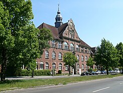
| Westend Clinic | |
| Basic data | |
| place | Berlin |
| District |
Charlottenburg , Westend , Spandau |
| Created | 18th century |
| Hist. Names |
Way to Spandau, Straße von Spandau, Am Spandauer Berg, Spandauer Berg, Spandauer Straße, Spandauer Chaussee |
| Connecting roads | Otto-Suhr-Allee , Charlottenburger Chaussee |
| Cross streets | (Selection) Kaiser-Friedrich-Strasse , Schloßstrasse , Danckelmannstrasse , Sophie-Charlotten-Strasse , AS to A 100 , Königin-Elisabeth-Strasse , Fürstenbrunner Weg , Soorstrasse , Bolivarallee , Reichsstrasse , Wiesendamm , Rominter Allee |
| Places |
Luisenplatz , Klausenerplatz |
| Buildings | look here |
| use | |
| User groups | Pedestrian traffic , bicycle traffic car traffic , |
| Technical specifications | |
| Street length | 3800 meters |
The Spandauer Damm is a main road connecting the Berlin districts of Charlottenburg and Westend .
course
The 3.8 km long arterial road begins as an extension of Otto-Suhr-Allee at Charlottenburg Palace and leads in the direction of Spandau . It ends across the district border between Charlottenburg-Wilmersdorf and Spandau on Rominter Allee , from where it continues as Charlottenburger Chaussee . In its course, it crosses the city motorway as well as the ring railway that runs parallel to it and touches the area of the Westend Clinic further to the west .
history

The route connecting Berlin and Spandau originally ran north of the Spree through the Jungfernheide . At the request of the Charlottenburg merchants and craftsmen, Friedrich I ordered in 1708 that traffic should be conducted via Charlottenburg. The actual establishment of the new Berlin – Spandauer Weg via Charlottenburg did not take place until ten years later, after the change of regent to Friedrich Wilhelm I , when Friedrich Wilhelm I , who was concerned with economic development, caused the zoo to be redesigned from a hunted hunting ground into a public park now the route through the zoo could also be opened for public traffic (order of May 7, 1718: "[...] that, since the route from Spandow via Charlottenburg anhero to Berlin , the zoo should be opened at the same passage") . In order to force traffic via Charlottenburg, the King also ordered the closure of the old Spandauer Weg through the Jungfernheide in 1723, which, however, quickly proved to be too impractical and was therefore lifted again in 1727. In return for the inclusion of their city in the postal service, the Charlottenburgers participated in the expansion of the street.
The street began on Schloßstraße and led over Magazinstraße (today: Neufertstraße ) and diagonally over today's Klausenerplatz , from where it led over the extremely sandy Spandauer Berg , which belongs to the Teltow . For a road connecting Berlin and Hamburg , the path was paved and straightened around 1820. At the suggestion of the Potsdam government, the Chaussee was led in a straight line past the palace and connected to Berliner Strasse , today's Otto-Suhr-Allee . A side effect of the elevated road was that when there was heavy rainfall, the water in the castle courtyard would accumulate. This then had to be piled up.
Before the street was given the current name 'Spandauer Damm' in 1950, the individual sections had the following names: Luisenplatz to Schloßstraße , Spandauer Straße to Sophie-Charlotten-Straße, Spandauer Berg to Ahornallee and Spandauer Chaussee to the Spandau border.
The Bavarian brewer Conrad Bechmann earned 1840 located at the angle between today Spandauerdamm and Reichsstrasse terrain and opened there a small serving, which in the vernacular " Spandau Bock " was called. In 1854 he moved his brewery from Spandau to the opposite site of the Spandauer Berg, which from then on was called "Spandauer Berg Brewery". The pub that arose there was called "Zibbe" ( northern German for ' mother sheep '). The two excursion restaurants and the brewery were destroyed in the Second World War.
local residents
- The doctor and poet Gottfried Benn lived and worked shortly before the First World War as a pathologist in the Westend Hospital.
- The Swiss writer Robert Walser lived in Spandauer Berg 1 from 1912.
traffic

Since June 22nd, 1865, the first horse tram line in Germany has been running between the Brandenburg Gate and the horse station at the intersection with Sophie-Charlotten-Straße . With the establishment of the Westend villa colony, the need for improved transport connections grew. On November 1, 1871, the Westend-Gesellschaft opened a connecting line between the horse-drawn train station and Kastanienallee. The company was run by the Berlin Horse Railway , which owned the line in 1878. For the line leading steeply up the Spandauer Berg to Westend, you had to change to one-story wagons with two horses at the horse station. The route was continued in 1879 to the “ Spandauer Bock ” restaurant where the Reichsstrasse joins the Spandauer Damm. At the beginning of the 20th century, this tram line was electrified and finally discontinued in 1967.
On November 15, 1877, the Westend station was opened with the commissioning of the Ringbahn . Since December 22nd, 1922, today's underground line U2 has had its terminus at the Ruhleben underground station .
Today the M45 bus runs on Spandauer Damm between Bahnhof Zoo and Johannesstift in Hakenfelde .
Buildings and places of note

- Prince Albrecht monument on the corner of Schloßstraße
- Schloss Charlottenburg
- Milestone in front of house no.7
- Eastern Stüler building with the Scharf-Gerstenberg collection
- western Stüler building with the Berggruen Museum
- Klausenerplatz
- Berlin-Westend train station
- Spandauer Damm Bridge
- Westend Clinic
- Westend water tower
- Dietrich Bonhoeffer primary school
- Ruhwaldpark with Villa Rheinberg
- Milestone in front of house no.220
- Residential town at the Ruhwaldpark
- Ruins of the Spandauer Berg brewery on the Spandauer Bock
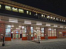
- Ruhleben underground station
Web links
-
Spandauer dam. In: Street name lexicon of the Luisenstädtischer Bildungsverein (near Kaupert )
- Spandauer Strasse . In: Luise.
- Hainer Weißpflug: Spandauer Damm . In: Hans-Jürgen Mende , Kurt Wernicke (Hrsg.): Berliner Bezirkslexikon, Charlottenburg-Wilmersdorf . Luisenstadt educational association . Haude and Spener / Edition Luisenstadt, Berlin 2005, ISBN 3-7759-0479-4 ( luise-berlin.de - as of October 7, 2009).
Individual evidence
- ^ Wilhelm Gundlach: History of the city of Charlottenburg. Springer, Berlin 1905. pp. 88–89, Textarchiv - Internet Archive
- ↑ Ulrich Wiesner: Why is the Brandenburg Gate actually called the “Brandenburg Gate”? Historic Association Brandenburg (Havel) e. V., Brandenburg an der Havel 2009, p. 221 ff . ( brandenburger-blätter.de [PDF]).
- ↑ Willy Bark: Chronicle of Alt-Westend . Mittler, Berlin 1937, p. 11
- ^ Wilhelm Gundlach: History of the city of Charlottenburg. Springer, Berlin 1905. p. 399, Textarchiv - Internet Archive
- ^ Paul Fürst: Charlottenburg in the mirror of history - II. From the small town to the urban district (1808–1876) . Oehmigsche Verlagsbuchhandlung, Berlin 1925, p. 38.
- ^ Author collective: Tram archive 5. Berlin and surroundings . transpress, Berlin 1987, ISBN 3-344-00172-8 , pp. 16 .
- ^ Dietrich Bonhoeffer Elementary School
Coordinates: 52 ° 31 ′ 9.9 ″ N , 13 ° 16 ′ 20.9 ″ E


