
Luisenplatz (Berlin)
| Luisenplatz | |
|---|---|
|
|
|
 View over Luisenplatz towards Charlottenburg Town Hall |
|
| Basic data | |
| place | Berlin |
| District | Charlottenburg |
| Created | 1806 |
| Newly designed | 1950s |
| Confluent streets |
Schloßbrücke , Spandauer Damm , Otto-Suhr-Allee , Kaiser-Friedrich-Strasse |
| use | |
| User groups | pedestrian |
| Space design | Green area |
| Technical specifications | |
| Square area | 187 m × 133 m |
The Luisenplatz is a place in the Berlin district of Charlottenburg the district Charlottenburg-Wilmersdorf . The road connection to the east between Spandauer Damm and the Schlossbrücke bears the same name . Until around 1950, the part of the Spandauer Damm adjoining the square to the south also bore the name Luisenplatz.
History and current state
Luisenplatz forms the forecourt of the Knobelsdorff wing of Charlottenburg Palace . "Charlottenburg Castle, a pile bridge leads from Luisenplatz" In Eosander's plan for the extension of the castle from the beginning of the 18th century, the square was intended as a baroque ground floor . On July 31, 1806, the square was given its current name in honor of the Prussian Queen Luise . In 1841 it was initially designed by Peter Joseph Lenné . Between 1902 and 1905 the square was redesigned by Otto Schmalz. A 4.5 meter high equestrian monument to Emperor Friedrich III was erected in the middle of the square . Erected by Joseph Uphues . On the occasion of the celebrations for the 200th anniversary of the city of Charlottenburg, the monument to Kaiser Wilhelm II was ceremoniously unveiled on May 27, 1905, one week after the inauguration of the new Charlottenburg town hall . The old Prussian mile column on Luisenplatz, which was then moved to its current location at the corner of Spandauer Damm and Nithackstraße , had to give way to the monument .
After bomb damage , the equestrian monument was melted down in 1943 for metal extraction and the destroyed monument complex was completely removed in 1950. The square was landscaped by Joachim Kaiser in the 1950s and since then has consisted of simple lawns, which are surrounded by paved paths and allow an unobstructed view from Spandauer Damm to the Knobelsdorff wing of the castle. The eastern boundary of the square is the street of the same name, which, as a northern extension of Kaiser-Friedrich-Strasse, leads from the intersection of Otto-Suhr-Allee and Spandauer Damm to the castle bridge over the Spree . The building ensemble of buildings on Luisenplatz by Hans Kollhoff to the east of the square refers to Luisenplatz .
Until Kaiser-Friedrich-Straße was led to Luisenplatz, the representative Landhaus Behrend designed by Karl Friedrich Schinkel was adjacent to the southeast corner of the square. It was demolished in the course of road construction around 1905.
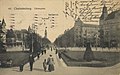
View over Luisenplatz towards Charlottenburg Town Hall , 1913

View over Luisenplatz towards Charlottenburg Palace

East side of the square seen from the south

Former monument to Emperor Friedrich III. by Joseph Uphues

Southwest view of the milestone, around 1903

View from Luisenplatz in east direction, postcard around 1900

Luisenplatz (a) on the location map from 1824


The Luisenplatz in Berlin-Mitte
In Friedrich-Wilhelm-Stadt in what is now Berlin's Mitte district , there was also a Luisenplatz from 1838 to 1932, named after Luise von Prussia , the daughter of Queen Luise. Today it bears the name Robert-Koch-Platz, but continues to end on Luisenstrasse.
Web links
- Information on Luisenplatz. District Office Charlottenburg-Wilmersdorf, with aerial photo from 1930
- Historical photos of the Kaiser-Friedrich-Monument
- Luisenplatz (Charlottenburg). In: Street name lexicon of the Luisenstädtischer Bildungsverein (near Kaupert )
Individual evidence
- ↑ JGA Ludwig Helling (ed.): Historical-statistical-topographical pocket book of Berlin and its immediate surroundings . HAW Logier, Berlin 1830
- ^ Stephan Brandt: The Charlottenburg old town. Sutton, Erfurt 2011, ISBN 978-3-86680-861-4 . P. 53.
- ↑ Milestones research group: The milestone in Berlin opposite the Charlottenburg Palace
- ↑ Kristiane Lichtenfeld: "A Mile from Berlin". From the milestone in front of the Charlottenburg Residence . In: Berlin monthly magazine ( Luisenstädtischer Bildungsverein ) . Issue 7, 2000, ISSN 0944-5560 , p. 76-80 ( luise-berlin.de ).
- ^ Stephan Brandt: The Charlottenburg old town. Sutton, Erfurt 2011, ISBN 978-3-86680-861-4 . P. 54.
Coordinates: 52 ° 31 '11.9 " N , 13 ° 17' 54" E