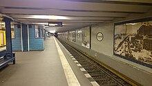
Uhlandstraße underground station (Berlin)
The uhlandstraße opened in 1913, the terminus is U1 of the Berlin subway in the district of Charlottenburg the district Charlottenburg-Wilmersdorf . It is located under Kurfürstendamm at the intersection with Uhlandstrasse . The exits of the sub-paved train station are on the central island of Kurfürstendamm.
history
The Uhlandstraße underground station is the terminus of the U1 line. Originally the station was built as the first station on a planned route to Halensee . The route should begin at the Wittenbergplatz underground station and head west under Kurfürstendamm . However, these plans have not yet been implemented. After the Wall was built, the station was the end of line 3 (initially B IV ), which consisted of only three stations: Wittenbergplatz, Kurfürstendamm and Uhlandstraße. Back then, a short train commuted between these stations every 10 minutes, and the rear part of the station was cordoned off. Only after the political turnaround did the U15 trains run through to Warschauer Strasse again . This line was renamed “U1” on December 12, 2004.
The underground station opened on October 12, 1913. It is located under the pavement and initially had a direct exit to the central island of Kurfürstendamm at both ends. The station was shut down between November 1957 and September 27, 1961, as the construction of the underground line G (today: U9 ) at the junction of Kurfürstendamm and Joachimsthaler Straße resulted in a crossing station . The operation of the line during the construction work was considered unnecessary and simplified the construction process. A few years after the new Kurfürstendamm crossing station went into operation, the eastern access to the station was closed on March 5, 1964. The BVG's first fully electronic signal box was located there between 1986 and 1999 . It has now been replaced by a more modern signal box.
After a fire in the Deutsche Oper underground station , it was decided that each BVG underground station should have two exits. In May 2005, a relatively narrow entrance to the east was opened. In 2010 a glass elevator was completed between the platform and street level on the Kurfürstendamm-Mittelinsel at Fasanenstraße , the construction costs amounted to 1.1 million euros.
future
To the west of the station is an extensive sweeping system . This was to become part of the unrealized underground line to Halensee . The extension of this route is planned, however, due to the tight budget situation in Berlin, the start of the expansion is not yet in sight. The next train station on the westbound route would be a new Schlüterstrasse train station to be built .
Connection
The underground station offers transfer options from the U1 line to the X10, M19, M29, 109, 110 and N10 bus lines operated by the Berliner Verkehrsbetriebe.
| line | course |
|---|---|
|
|
Uhlandstraße - Kurfürstendamm - Wittenbergplatz - Nollendorfplatz - Kurfürstenstraße - Gleisdreieck - Möckernbrücke - Hallesches Tor - Prinzenstraße - Kottbusser Tor - Görlitzer Bahnhof - Schlesisches Tor - Warschauer Straße |
bus
| line | course |
|---|---|
| M19 | S Grunewald - Taubertstr. - S Halensee - U Uhlandstr. - U Kurfürstendamm - U Mehringdamm |
| M29 | Roseneck - S Halensee - U Uhlandstr. - U Wittenbergplatz - U Hermannplatz / Urbanstr. |
| X10 | Hertzallee - S + U Zoological Garden - U Uhlandstr. - Am Rehwechsel - Teltow , Zehlendorfer Str. - S Teltow Stadt / Gonfrevillestr .; ... - Teltow, Zehlendorfer Str. - Teltow, Rammrath Bridge |
| 109 | Tegel Airport - U Uhlandstr. - S + U Zoological Garden - Hertzallee |
| 110 | Hertzallee - S + U Zoological Garden - U Uhlandstr. - U Oskar-Helene-Heim |
| N10 | Hertzallee - S + U Zoological Garden - U Uhlandstr. - Sachtlebenstr. |
Web links
- Entry in the Berlin State Monument List
- BVG map of the station (PDF; 35 kB)
- Brief description of the history of the east entrance of the Uhlandstrasse station
- Description of the train station at berliner-untergrundbahn.de
- More pictures and signal box description at untergrundbahn.de
Individual evidence
- ↑ Tom Gerlich: BVG presents construction projects for 2010 , Bahninfo.de, December 3, 2009
- ↑ Berliner Verkehrsblätter (01/2011), p. 13
Coordinates: 52 ° 30 ′ 9 ″ N , 13 ° 19 ′ 32 ″ E


