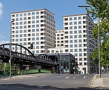
Mendelssohn-Bartholdy-Park underground station

The Mendelssohn-Bartholdy-Park underground station is a station on the U2 underground line in the Tiergarten district of Berlin . The internal BVG abbreviation is MB . It takes its name from the adjacent park , which in turn is named after the composer Felix Mendelssohn Bartholdy .
As the second-youngest station of the small profile - subway network it is also the oldest stretch of opened on 18 February 1902 original route .
history
prehistory

Due to the construction of the Berlin Wall on August 13, 1961, the route of today's U2 line was interrupted precisely at this point, i.e. between the railway stations Gleisdreieck in the western part and Potsdamer Platz on the sector border with East Berlin .
Since the elevated railway line from here to Nollendorfplatz lost its importance due to the changed traffic situation, it was taken out of service soon after the wall was built and used in the northern area between 1984 and 1991 for the M-Bahn that was operating there at the time ; The M-Bahn stop at Bernburger Strasse was located north of today's underground station .
After the reunification period and station building
As a result of the fall of the Berlin Wall , the two separate subway sections were reconnected after initial concerns by the Federal Ministry of Transport .
The elevated railway line between Gleisdreieck and Potsdamer Platz was completely rebuilt, including the ramp at the northern end, as the construction was last repaired with armored steel after the Second World War and only provisionally . The ramp was swiveled around 100 meters to the north, as the train station that has now been planned would otherwise have been in its area. For this purpose, the tunnel mouth was opened accordingly.
The already existing plans for the station became more concrete with the construction of the Daimler quarter west of the elevated railway line, as the company responsible for the construction wanted good local transport connections and originally also offered to finance the new station. The BVG rejected this as unprofitable and built the station from February 1998 at its own expense. These were initially estimated at around 20 million marks and ultimately amounted to eleven million euros. The planning of the new building was carried out by Hilmer & Sattler and Albrecht . The topping-out ceremony was celebrated on July 27th .
opening
On October 2, 1998, the Mendelssohn-Bartholdy-Park station, originally planned as a harbor square , was the 169th station on the Berlin subway network. However, the northern entrances remained closed until 1999 because of a construction logistics road running directly in front of it.
Building
Instead of a central platform , the construction of which would have impaired traffic on the important east-west subway line, two side platforms , each 113 meters long , were built for the station during ongoing operations . As a typical high station, it also received a hall that widens in a westerly direction. In addition to stairways, elevator systems allow barrier-free access to both platforms.
A pedestrian bridge opened in 1999, which connected the western side platform with the parking garage south of the Landwehr Canal, was demolished again in September / October 2019.
Location and surroundings
The train station is located north of the Landwehr Canal and is bordered by Reichpietschufer , Köthener and Bernburger Strasse and the Gabriele-Tergit-Promenade. In the vicinity are both the park, which ultimately gives the station its name, and the harbor square after which the station was originally supposed to be named.
The ramp to the mouth of the tunnel in the direction of Potsdamer Platz and a few meters of the station were built over after its completion. As a result, the subway now runs under a hotel complex. In the medium term, the planned S-Bahn line S21 is to be run alongside the route in the immediate vicinity . For this purpose, a tunnel was built as a preliminary construction work.
Connection
At the underground station you can change from the U2 line to the M29 metrobus line operated by Berliner Verkehrsbetriebe.
literature
- Berlin Heritage Preservation Association V .: U2. Story (s) from the underground . Verlag GVE, Berlin 1995, ISBN 3-89218-032-6 .
Web links
- BVG map of the station (PDF)
- Information about the underground station on the website of the Berlin urban development administration
- Mendelssohn-Bartholdy-Park at berliner-untergrundbahn.de
Individual evidence
- ^ Peter Neumann: BVG is building its first underground station with its own money by October. In: Berliner Zeitung , July 28, 1998
- ^ A b Peter Neumann: U-Bahn stops next to the Debis quarter. In: Berliner Zeitung , January 22, 1998
- ↑ a b Information on the underground station on the website of the Berlin urban development administration
- ↑ a b station number 169. Short message in the Berliner Zeitung , October 2, 1998
- ^ Anne-Kathrin Peitz: Open entrances to the subway. In: Berliner Zeitung , August 27, 1999
- ↑ News in brief - U-Bahn . In: Berliner Verkehrsblätter . No. 11 , 2019, pp. 225 .
Coordinates: 52 ° 30 ′ 14 ″ N , 13 ° 22 ′ 30 ″ E

