
Güntzelkiez

The Güntzelkiez is a residential area in the Berlin district of Wilmersdorf in the Charlottenburg-Wilmersdorf district .
location
The area south of Hohenzollerndamm , between Brandenburgischer Strasse , Bundesallee and Berliner Strasse , is commonly known as Güntzelkiez. It is named after the central Güntzelstraße with the underground station named after it . The neighborhood essentially comprises the southwest area of the Wilmersdorfer Carstenn figure around Nikolsburger Platz .
structure
The area has a typical Berlin neighborhood structure, i.e. largely preserved pre-war buildings with an island-like location and a closed infrastructure with shops, restaurants and educational institutions, which make the quarter an identity-creating social space for the residents.
Schools and public institutions
- Nelson Mandela School (Campi in Pfalzburger Straße)
- Cecilienschule on Nikolsburger Platz
- Swedish School Berlin
- Comenius School Berlin
- Dietrich Bonhoeffer Library, Brandenburgische Strasse 2
- The Pfalzburger, addiction clinic of the Tannenhof Berlin-Brandenburg
- Adventure playground in Güntzelkiez at Holsteinische Strasse 45
- Bullying advice Berlin-Brandenburg, Uhlandstrasse 127
Churches
- Evangelical Church on Hohenzollernplatz
- Evangelical Lutheran Church of the Holy Cross
- Swedish Church Berlin
Diplomatic institutions
- Cultural Office of the Embassy of the Kingdom of Saudi Arabia at Bundesallee 22
photos
- Pictures from the Güntzelkiez
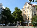
Glance into Güntzelstrasse

Weekly market on Hohenzollernplatz

Pfalzburger Strasse
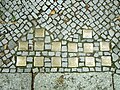
Numerous stumbling blocks remind of victims of the Shoah (here: Nassauische Strasse 30)

Cecilia School


Web links
- Five reasons for the Güntzelkiez . In: Qiez
Individual evidence
- ↑ Eve-Catherine Trieba: The Güntzelkiez in Wilmersdorf is one of the most beautiful quarters in Berlin for us. Retrieved March 18, 2017 .
- ↑ A foray through the Güntzelkiez. Retrieved March 18, 2017 .
- ↑ Neighborhood and Self-Help Center in the ufaFabrik e. V., Berlin: Adventure playground in the Guentzelkiez neighborhood center. Retrieved March 18, 2017 .
- ^ Bullying advice Berlin-Brandenburg. Retrieved March 18, 2017 .
Coordinates: 52 ° 29 ′ 27.8 ″ N , 13 ° 19 ′ 40.2 ″ E