Dresden suburbs
The Dresden suburbs form a closed ring around the historic city center of Dresden . In urban development, the suburbs represent the districts of Dresden that were not incorporated as a village or city, but rather emerged through the growth of the city itself. Around 120,000 people live in the Dresden suburbs, around a fifth of Dresden's population .
Overview of the districts
geography
location
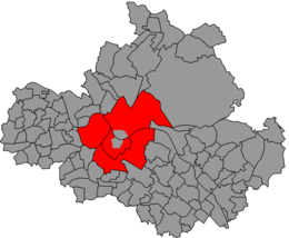
The ten Dresden suburbs enclose the Inner Old Town on the western, southern and eastern sides and the Inner New Town on the right bank of the Elbe on the northern side. Four of them - Äußere Neustadt , Albertstadt , Leipziger and Radeberger Vorstadt - are on the Neustadt side on the right Elbe. Together with the Inner Neustadt and Albertpark , they form the Neustadt district . The six remaining suburbs are located on the old town side to the left of the Elbe and can be divided into three inner and three outer suburbs. The inner suburbs - Pirnaische Vorstadt , Seevorstadt and mostly also the Wilsdruffer Vorstadt - are located within the 26er Ring . With the exception of the part of the Wilsdruffer Vorstadt located outside of it, they form the district Old Town I together with the inner old town . The outer suburbs - Johannstadt , Südvorstadt and Friedrichstadt - are on the other hand outside the 26er Ring. Südvorstadt and Johannstadt, together with the outer Wilsdruffer Vorstadt, the southeastern Pirnaische Vorstadt and the Great Garden, form the district of Altstadt II , while Friedrichstadt is its own district . All four suburbs on the Neustadt side of the Elbe are also outside of the 26er Ring, which only includes the Inner New Town there.
administration
The suburbs on the Neustadt side of the Elbe are now combined with the Inner Neustadt to form the Neustadt district, the structure of which is divided into statistical districts , both by name and approximately based on the extent of the historical districts. On the old town side of the Elbe, the three inner suburbs together with the inner old town and large parts of Friedrichstadt and Johannstadt form the old town district . The Südvorstadt, on the other hand, belongs to the Plauen district . However, on the old town side of the Elbe, the historical structure gave way to a new one. In addition to the inner old town, only Friedrichstadt and Pirnaische Vorstadt each have their own statistical district. The Johannstadt (Johannstadt-Nord and -Süd) and the Südvorstadt (Südvorstadt-Ost and -West) each consist of two statistical districts. The Wilsdruffer Vorstadt and the part of the Seevorstadt west of Reitbahnstraße together form the statistical district of Wilsdruffer Vorstadt / Seevorstadt-West . The eastern part of Seevorstadt was combined with the Great Garden to form the statistical district of Seevorstadt-Ost / Great Garden .
Demarcation
The boundaries of the Dresden suburbs are marked by bodies of water, some of which no longer exist today, or by streets or the old Dresden boundary . They were separated from the city center by their location outside the old Dresden and Dresden fortifications . The old and new town suburbs are separated from each other by the Elbe.
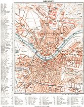
The historical outer border of the Outer Neustadt runs from the banks of the Elbe at the level of the bronze sculpture "Archer" through the perennial garden and along Hospitalstrasse to Albertplatz . From there it follows Königsbrücker Straße to the former edge of the forest, which it met before the construction of Albertstadt at about the confluence of Eberswalder Straße (see map section from 1863 and the southern border of Albertstadt on the city map section from 1917 ). Along the former edge of the forest of the Dresdner Heide , today roughly identical to the lower slope edge on the north side of the Alaunplatz , it runs to the Prießnitz, and then follows it to its confluence with the Elbe.
To the west of Königsbrücker Strasse is the Leipzig suburb, which was defined and demarcated as a factory district by local statute in 1878, Albertstadt to the north of Alaunplatz and the Radeberger Vorstadt to the east of Prießnitz. Theresienstraße marks the historical border between Innerer Neustadt and Leipziger Vorstadt; the slope edge on Hechtstrasse forms the border between Leipziger Vorstadt and Albertstadt. The border between Albertstadt and Radeberger Vorstadt initially runs between Jägerstrasse and Stauffenbergallee, then further east along Radeberger Strasse and Charlottenstrasse to Angelikastrasse.
The course of the old Weißeritzmühlgraben - today the Annenstrasse / Falkenstrasse line - is the border between See- and Wilsdruffer Vorstadt, the Kaitzbach an Bürgerwiese and Georgplatz as the border between See- and Pirnaischer Vorstadt. The Johannstadt extends in the south to the Great Garden. The boundary between Friedrich- and outer Wilsdruffer suburbs marks the former course of the Weißeritz , until the 1990s still traceable through the Elbezweigbahn with the former Dresden coal station . The border between Wilsdruffer Vorstadt in the west and Südvorstadt in the east runs along the Dresden – Werdau railway with the Dresden-Altstadt station .
Infrastructure
Due to their central location in the city, the suburbs play an important role in the infrastructure of the entire urban area. The transport port and the main train station and Neustädter Bahnhof are both of the city’s long-distance train stations in the suburb ring . In addition, the federal highways leading to Dresden converge there , and there are also several important Elbe crossings in Dresden in the suburbs with Marien , Carola , Albert and Waldschlößchen bridges . The surrounding districts were supplied with hot water from the former central heating plant . The important Dresdner hospitals are located in the suburbs on both Elbseiten so above all, founded in 1954 from the Medical Academy Dresden incurred University Hospital Carl Gustav Carus in the Johann city and the Municipal Hospital in the city of Frederick. The large sports facilities such as the Rudolf Harbig Stadium and the Heinz Steyer Stadium are also located in this suburban belt . There are also recreational areas and green spaces, such as the Great Garden , the Ostragehege and the Alum Park .
history
Development up to the 17th century
The suburbs developed around the two cities of Dresden, today the Inner Old Town, and Altendresden , today's Inner New Town. They were located outside of their fortifications and mostly consisted of small wooden houses along narrow streets. Already in the 15th century they had a significant number of inhabitants, but were repeatedly destroyed during times of war. The early settlements on the left Elbe area that already existed in the Middle Ages include Ostra and Wetzegrelle. With Ramwoltitz, Rostagk and Wernten, there were also several places in the later suburbs that became deserted in Dresden . In addition, the area around today's Neumarkt with the old Frauenkirche , which was only included in the expansion of the city walls to Dresden around 1530, was considered a suburb. At that time there were no suburbs on the Neustadt side of the Elbe. The closest settlements were initially Pieschen downstream, Loschwitz upstream and Rähnitz in the north.
With Neudorf , a nucleus of what would later become the Leipzig suburb , the first suburb on the right bank of the Elbe was not founded until 1546 and granted city rights as early as 1550. On March 29, 1549, Elector Moritz decreed the merger of Dresden and Altendresdens. Even then, the immediate foreland of both places or fortresses was part of the urban corridor; The soft picture , which Dresden's soft picture stones testify, extended a little further . By 1554, additional areas were incorporated into Dresden, which resulted in an expansion of the urban area to around 19 square kilometers. The village of Ostra, west of Dresden, came into the possession of Elector August in 1559 , who had it dissolved in 1568. In its place he founded the Ostravorwerk , which had to ensure the supply of the court and the Dresden fortress. As compensation, the former villagers mainly received formerly monastic lands near Leubnitz , where they settled and founded the village of Neu-Ostra .
Development in the 18th century

The Ostragehege and the suburb Ostra were built around the Ostravorwerk , which was renamed Friedrichstadt in 1730 after the Saxon Elector Friedrich August II and can be considered the first closed suburb. On the right-hand side of the Elbe, a “new extension on the sand” was built in the 18th century, which developed into Antonstadt, initially named after King Anton , today's Outer Neustadt.
With the introduction of the general consumption excise tax in 1703, the suburbs were clearly delimited compared to the surrounding area: A turnpike (known as Schlag in Dresden ), to which the tax (colloquially called "market money") had to be paid, also visually delimited all suburbs.
In addition to Friedrichstadt, the other Dresden suburbs on the left Elbe continued to expand until the 18th century. The elector 's later so-called municipalities Friedrichstadt and Ostra were under the control of the elector . There were also ten independent municipalities subject to the supervision of the council (Ratsgemeinden). The "fishing community" was on the banks of the Elbe, on the eastern part of what is now the Terrassenufer. To the south of it was the "Rampische Gemeinde", which stretched along today's Ziegelstrasse and Pillnitzer Strasse. The “Pirnische Gemeinde” was located on Pirnaische and Grunaer Strasse (which did not exist at the time). In the area of Lingnerallee and the corner of St. Petersburger Strasse, there was also the “Borngasser community”. South of the old town was the “Halbe- und Eulengasser municipality” on the west side of what would later become the Bürgerwiese , the “Hinterseeische Gemeinde” in the area of today's Centrum-Galerie and Pragerzeile . The economically strongest and most populous Dresden suburbs were located between the old town and Friedrichstadt: the community “ Poppitz ” (also “Poppitz community”, strictly speaking, an independent village that is also older than Dresden) around today's Sternplatz as the center, however the neighboring "Halbe- and Eulengasser municipality" belonged to the entire Seevorstadt West. The " Fischersdorfer Gemeinde " was not far from it (later Fischhofplatz ) a little south of Freiberger Strasse , the "Entenpfütze" formed what would later become Freiberger Platz . In the Hertha-Lindner- / Freiberger / Schweriner Strasse area was the “ tannery community ” with its centers, the mills along what would later become Theaterstrasse and outside of it the “cattle pasture community” on Laurinstrasse and Ritzenbergstrasse.
Development in the 19th century
Until its demolition from 1809 to 1829, the city fortifications surrounded the inner old town. The inner suburbs then expanded into these now free areas. In the meantime, the individual suburbs grew closer and closer together. Fischer, Rampische, Pirnaische and Borngasse communities formed the Pirnaische Vorstadt, Halbeulengassen, Oberseer and Unterseer communities became Seevorstadt and the five communities between Altstadt and Friedrichstadt became Wilsdruffer Vorstadt. These three suburbs, which united with Dresden around 1835, got their names from their location in front of the respective earlier city gates. However, the irregular and dense development of the suburbs sometimes had an adverse effect on the emerging city. As there was too little traffic space, wide road openings between the inner old town and the outer suburbs were necessary. In this way, from 1851 to 1853, Prager Strasse was created in Seevorstadt as a connection to the Bohemian Railway Station , from 1872 to 1875 Wettiner Strasse as a link between Postplatz and Schäferstrasse and between 1878 and 1880 Grunaer Strasse as a direct link between Pirnaischer Platz and the north on the Große Garden along the road to Pirna (today's Stübelallee). Since then, the Dresden suburbs have played an important role in the urban infrastructure.
In 1836 Friedrichstadt was incorporated into Dresden. There were also largely undeveloped areas in the later Radeberger Vorstadt, the northern Outer Neustadt (Antonstadt) and the later Leipzig suburb. From the 1840s onwards, the “new extension on the von Oppellschen fields” developed there, later referred to as Oppellvorstadt and now known as the Hechtviertel (Unterer Hecht). The area of the Radeberger Vorstadt was also built extensively in the 19th century, including the Waldschlösschenviertel and the Prussian quarter . On the old town side of the Elbe, an extension of the built-up area beyond the inner suburbs resulted in the later Johannstadt (from 1872, formerly Äußere Pirnaische Vorstadt, name since 1877) and the Südvorstadt. On January 1, 1866, Neudorf was incorporated, and on January 1, 1892, Albertstadt was finally incorporated. With that, the inner city of Dresden was essentially complete. Also in 1892, Strehlen , the first village not belonging to the inner city, came to Dresden.
The suburbs have developed very differently in terms of their structure and development. The densely populated Wilsdruffer suburb was very much shaped by commerce. The Dresden red light district was also located there . The lakeside suburb, which was long characterized by gardens, experienced an upswing due to its proximity to the Saxon-Bohemian Railway . The Pirnaische Vorstadt was only densely built in its northern part, the south with the Blüherpark and Güntzwiesen remained free. The Radeberger Vorstadt was characterized by mansions, the Äußere Neustadt by dense Wilhelminian style buildings, the Leipziger Vorstadt by industry and the Albertstadt by the military. Friedrich- and Johannstadt as well as the eastern part of the Südvorstadt, on the other hand, were densely built-up residential suburbs, while the Südvorstadt west of Reichsstraße (today: Fritz-Löffler-Straße) between the main train station and Nürnberger Straße became one of the noblest addresses for the upper class.
Development in the 20th century

In the first half of the 20th century, the Dresden suburbs moved from the outskirts to the city center through the expansion of the urban area through numerous incorporations and are therefore partially perceived as part of the city center. Districts that were incorporated around 1900, such as Gruna and Trachau , were initially temporarily referred to as suburbs (e.g. "Vorstadt Trachau"). As an autarkic military town, Albertstadt was once again temporarily independent from 1934 to 1945, but was not a municipality in the normal sense and was always statistically included in Dresden. During the 1930s, the National Socialists planned the establishment of a Saxon Gauforum in the Pirnaische Vorstadt , which was not carried out.
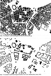
The air raids on Dresden in 1945 led to a deep turning point . As a result, in addition to the inner old town, the Wilsdruffer, the Pirnaische, the See- and Südvorstadt as well as the Johannstadt in particular were destroyed. After the rubble had been cleared, they formed huge contiguous open spaces. During the rebuilding, the urban morphological structure that had grown in the city was partly ignored. Old village squares like those of Poppitz and Fischersdorf in Wilsdruffer Vorstadt were built over with monotonous apartment blocks. The Seervorstadt was divided into two parts by the new construction of Prager Strasse as a socialist boulevard. The residential buildings in the southern Pirnaischer Vorstadt gave way to the Robotron site at Pirnaischer Platz ; Currently, the district represents an essential inner-city development area.
The names of the three suburbs in Dresden's old town - Pirnaische and Wilsdruffer Vorstadt and Seevorstadt - disappeared from official linguistic usage and were only officially used again after 1990.
Large-scale prefabricated buildings were built in Johannstadt . In addition, the socialist city planners laid out wide streets with wide green strips, including St. Petersburg Street . Since the 1990s there have been plans to subsequently densify these central urban spaces. In 1945, however, the suburbs on the Neustadt side of the Elbe were largely undamaged. After decades of structural neglect during the time of the GDR , the Äußere Neustadt developed into a trendy district in Dresden after the fall of the Wall . Attempts are made to counteract the urban and social development deficit in the Leipzig suburb during the 1990s with a funding program and a master plan presented in 2010 .
literature
- Stadtlexikon Dresden A-Z . Verlag der Kunst, Dresden 1995, ISBN 3-364-00300-9 .
- Dresden (= values of our homeland . Volume 42). 1st edition. Akademie Verlag, Berlin 1984.
Web links
Individual evidence
- ↑ Municipal statistics office: population at the place of the main residence according to statistical districts . Dresden 2011.
- ↑ Cf. address and business manual of the Royal. Capital and residence city of Dresden. 1871. Section II: Business Manual. Dresden 1871, p. 51 ( digitized version ).
- ^ Karlheinz Blaschke : The urban area in the Middle Ages and early modern times . In: Karlheinz Blaschke (Hrsg.): History of the city of Dresden. Volume 1: From the beginning to the end of the Thirty Years War . Theiss, Stuttgart 2005, ISBN 3-8062-1906-0 , pp. 290–301, here: pp. 292–294. Map for this in the same work p. 426/427.
- ↑ Superordinate district planning . The southern Pirnaische Vorstadt with the former Robotron area. In: dresden.de. State capital Dresden, accessed on August 23, 2015 .
- ^ Project area northern suburb of Dresden. In: dresden.de. State capital Dresden, accessed on August 23, 2015 .


