Weißeritz
| Weißeritz (united) | ||
|
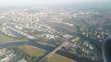
The Weißeritz flows into the Elbe in Dresden |
||
| Data | ||
| Water code | DE : 53729 (United Weißeritz) | |
| location | Dresden region | |
| River system | Elbe | |
| Drain over | Elbe → North Sea | |
| origin | Association of Roter and Wilder Weißeritz in Freital-Hainsberg 50 ° 58 ′ 54 ″ N , 13 ° 37 ′ 46 ″ E |
|
| Source height | 183 m above sea level NN | |
| muzzle | in the Elbe in Dresden-Cotta Coordinates: 51 ° 3 '48 " N , 13 ° 41' 12" E 51 ° 3 '48 " N , 13 ° 41' 12" E |
|
| Mouth height | 104 m above sea level NN | |
| Height difference | 79 m | |
| Bottom slope | 5.8 ‰ | |
| length | 13.7 km | |
| Left tributaries | Wiederitz , Roßthaler Bach | |
| Right tributaries | Poisenbach , Vorholzbach , Burgker Bach | |
| Big cities | Dresden | |
| Medium-sized cities | Freital | |
The Weißeritz ( Sorbian Bystrica - "fast, wild water"), also: United Weißeritz called, is a 13.7 km long tributary of the Elbe in Saxony. Together with the longest source river “Wilde Weißeritz”, it is 61 km long.
River course
The Weißeritz arises near Freital-Hainsberg from the two source rivers Rote Weißeritz and Wilde Weißeritz . It flows on through the Döhlen basin in the local area of Freital and then enters the Plauenschen Grund . At the end of this narrow valley, the Weißeritz flows through the Dresden district of Cotta and flows into the Elbe from the left in the Elbe valley basin there .
history
Around 1570, work on Dresden's fortifications led to the relocation of an earlier Weißeritz arm and its confluence with the Elbe. In the course of this work, the area of the mouth of this Weißeritz arm disappeared at what was then Dresden Castle . The water drainage formed as a ditch then extended down the Elbe to a new estuary and in the area between the Small and Large Ostragehege towards a floodplain zone called "Wilde Weisseritz" by Cornelius Gurlitt . Gurlitt also describes the course known as Weißeritzmühlgraben as "Weisseritz" and refers to the work of Rochus zu Lynar . The alluvial cone of the Weißeritz is characterized by the gravel that characterizes it and runs on its right side under the Zwinger up to the palace complex and on its right edge extends into Friedrichstadt .
In the 19th century, the Weißeritz flowed into the Elbe just below the Dresden city center (roughly at the location of today's Marienbrücke ). For the recovery of land and as a preparation for the widening of the railway line between Dresden Hauptbahnhof and Dresden-Neustadt which was mouth Weißeritz laid. The last part of the lower reaches is a canal along the Emerich Ambros bank . Until 1937 the Weißeritzmühlgraben branched off considerable amounts of water on the border between Plauen and Löbtau .
Former mills

Many mills no longer exist, some have been rebuilt and serve other purposes.
- Mehnertmühle (Hainsberg)
- Thode'sche paper factory in Hainsberg (originally using water power, but no mill)
- Egermühle (Deuben)
- Boehmert mill (Deuben)
- Rote Mühle (Döhlen, demolished in 1937)
- Winkelmühle (Döhlen)
- Obermühle ( Potschappel , demolished in 2002)
- Hofemühle (Potschappel)
- Eisenhammer (Dölzschen), later König-Friedrich-August-Hütte (originally using water power, but no mill)
- Powder mill (Coschütz)
- Wheat mill (Coschütz), also known as a copper hammer, garrison mill or commissary mill
- Neumühle (Dölzschen), later also called Braunesche Weizenmühle (after Hofbäcker Gottfried Braune) or König-Friedrich-August-Mühle
- Old and New Königsmühle (Dölzschen, now converted into apartments)
- Buschmühle (Coschütz), also Schweizer- or Grundmühle (demolished in 1857 when the Felsenkeller brewery was built )
- Bienertmühle (Hofmühle Plauen)
- Cloth fulling mill (Plauen, am Hofmühlengraben, last veneer cutting mill, demolished in 1898)
- Fulling mill (Plauen, broken off in 1934)
- Spiegelschleife (Plauen, last chocolate factory 1887–1945, demolished after destruction in 1945.)
Then the main inlet of the Weißeritzmühlgraben branched off to the northeast. There were other mills on this.
Flood in 2002
During the floods in 2002 , the Weißeritz in Dresden looked for its old river bed again through Weißeritzstraße and flooded the districts of Plauen , Löbtau , Friedrichstadt between the canal and the Elbe , the historic old town and the main train station.
Along the entire course of the Rote Weißeritz from Altenberg to Freital, on the Wilden Weißeritz in Tharandt and Freital and on the Vereinigte Weißeritz from Freital to Dresden, the floods caused great damage to houses, roads and rail systems. The Dresden – Chemnitz line , especially Tharandt and Dresden Central Station , and the Weißeritztalbahn were particularly affected .
As a consequence of the flood, the Weißeritz was rebuilt for comparable floods. For this purpose, various bridges were renewed and widened, the river cross-section enlarged and equipped with flood plains. The curve of the Weißeritz in Dresden-Löbtau will also be enlarged in order to facilitate the process into the Emerich-Ambros-Ufer. The bridge of the Weißeritztalbahn in Obercarsdorf can now be raised during high water. The Malter dam has not been completely filled since 2002 for flood protection. As a result of these measures, the 2013 flood caused only minor damage.
gallery
Weißeritztalbrücke , Plauenscher Grund ( BAB 17 )
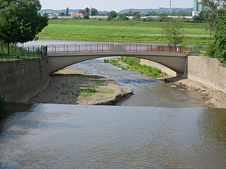
Weir immediately in front of the mouth when the water level is normal
See also
literature
- Between Müglitz and Weißeritz (= values of the German homeland . Volume 8). 1st edition. Akademie Verlag, Berlin 1964.
- Hydrological manual. (PDF; 115 kB) Part 2 - Area Codes. Free State of Saxony - State Office for Environment and Geology, p. 5 , accessed on December 25, 2017 .
- Eberhard Gürtler: Barrages - mill ditches. Eyewitnesses long past. Freital 2006 ( digitized version )
- Wolfgang Thomas, Reimar Börnicke: Along the Weißeritz . Bildverlag Böttger, Witzschdorf 2007. ISBN 978-3-937496-18-4 .
Web links
Individual evidence
- ↑ Weisseritz water profile (PDF; 3.1 MB)
- ↑ Cornelius Gurlitt : Descriptive representation of the older architectural and art monuments of the Kingdom of Saxony. City of Dresden . Volume 2, Dresden (Meinhold & Sons) 1901, p. 315, 327–328
- ↑ Plan of the village of Ostra in 1568. In: Otto Richter: Atlas zur Geschichte Dresdens . Dresden 1898
- ↑ Wolfgang Alexowsky: Geological map of Saxony 1:25 000. Sheet 4948 Dresden . Freiberg 2001, signature 10.
- ↑ http://skd-online-collection.skd.museum/Details/Index/796102
- ↑ http://skd-online-collection.skd.museum/Details/Index/794990
- ↑ http://skd-online-collection.skd.museum/Details/Index/774580
- ↑ http://skd-online-collection.skd.museum/Details/Index/772062
- ↑ http://skd-online-collection.skd.museum/Details/Index/733692
- ↑ Peter Weckbrodt: Living in a former wheat mill, in DNN No. 20 of January 24, 2017, p. 12
- ↑ http://skd-online-collection.skd.museum/Details/Index/734022
- ↑ http://skd-online-collection.skd.museum/Details/Index/730253
- ↑ http://skd-online-collection.skd.museum/Details/Index/730012
- ↑ http://skd-online-collection.skd.museum/Details/Index/714803
- ↑ http://skd-online-collection.skd.museum/Details/Index/689858


