Emerich Ambros Shore
| Emerich Ambros Shore | |
|---|---|
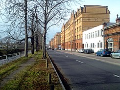
| Street in Dresden | |
| eastern section of the Emerich-Ambros-Ufer | |
| Basic data | |
| place | Dresden |
| District | Friedrichstadt , Löbtau |
| Hist. Names | Weißeritzufer |
| Connecting roads | Lübecker Strasse, Flügelweg, Löbtauer Bridge, Columbusstrasse, Löbtauer Strasse |
| Cross streets | Fröbelstrasse, Wernerstrasse, Wernerplatz |
| use | |
| User groups | Motor traffic , pedestrian traffic , bicycle traffic |
The Emerich-Ambros-Ufer is an inner-city street that runs on both sides of the Weißeritz in the Dresden districts of Friedrichstadt and Löbtau . It is part of the outer city ring and connects the Löbtauer / Nossener bridge with the Flügelweg bridge and the Fröbel- / Coventrystraße .
course
The Emerich-Ambros-Ufer runs left and right of the Weißeritz. Both parts of the street are one-way streets for motor traffic. The right side of the Weißeritz is for the traffic Löbtauer − Flügelwegbrücke (in the direction of flow), the side left of the Weißeritz for the traffic Flügelweg − Löbtauer Brücke.
The Emerich-Ambros-Ufer begins from Löbtau on Löbtauer Straße (eastern part of the street) or at the intersection of Wernerstraße and Columbusstraße (western part of the street) and initially runs in a northerly direction. About 300 meters further on, the lanes of the Löbtau bridge lead into the Emerich-Ambros-Ufer. In the following course to Fröbelstraße, the street is classified as federal highway 173 . After the crossing at Fröbelstraße, the Emerich-Ambros-Ufer continues along the Weißeritz in a north-westerly direction. The western part of the street then flows into Lübecker Straße. The eastern part of the road is about 300 meters longer and only ends at the Flügelweg.
history
Between 1891 and 1893 the Weißeritz was relocated to the west. After the work was completed, a riverside road was built on both sides of the new river bed. In the years 1894 and 1898 both parts of the street were given the name Weißeritzufer .
After the end of the Second World War in 1945, the street was named after the Hungarian resistance fighter Emerich Ambros (1896–1933), who was murdered in the Hohnstein concentration camp . Before his arrest by the Nazis, he worked in the nearby Reichsbahn repair shop in Dresden . A plaque on the Emerich-Ambros-Ufer 50 building has been commemorating him since 2006.
In the 1990s, part of the Dresden western bypass was expanded. An extension of the western part of the street from Lübecker Straße to Flügelweg is planned, but is currently not actively pursued.
Development
The street was built from 1893 with houses for the workers of the Dresden-Friedrichstadt marshalling yard and the railway company. In 1917 the allotment garden division "Providentiae" was created on the former Reichsbahn site. After the war it was named "Lübecker Ecke" and with currently 249 parcels is one of the largest allotment gardens in Dresden.
In 1934, a sports field was built east of the Emerich-Ambros-Ufer by railway workers . The area was expanded in the following years, and in 1956 the largest sports hall in Dresden was built here. Today the area is used by the Dresden Railway Sports Club .
Today there are nine Dresden cultural monuments on the Emerich-Ambros-Ufer .
Web links
- Streets and squares in Friedrichstadt on dresdner-stadtteile.de
Coordinates: 51 ° 3 '9.7 " N , 13 ° 41' 53.4" E


