Poisenbach
| Poisenbach | ||
|
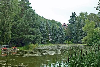
Pond in Welschhufe (Bannewitz) fed by the Poisenbach |
||
| Data | ||
| location | Dresden region | |
| River system | Elbe | |
| Drain over | Weißeritz → Elbe → North Sea | |
| Poisenbach source | Brooch | |
| Source height | 390 m above sea level NN | |
| muzzle | in the Weißeritz in Freital-Deuben Coordinates: 50 ° 59 '52 " N , 13 ° 39' 11" E 50 ° 59 '52 " N , 13 ° 39' 11" E |
|
| Mouth height | 170 m above sea level NN | |
| Height difference | 220 m | |
| Bottom slope | 28 ‰ | |
| length | 8 kilometers | |
| Medium-sized cities | Freital | |
| Communities | Bannewitz | |
The Poisenbach is a right tributary of the United Weißeritz and is located in the area of the municipality of Bannewitz and the city of Freital .
course
The Poisenbach rises in the Bannewitz district of Börnchen at 390 m above sea level. NN and initially flows in a northerly direction. In Wilmsdorf it swings to the northwest and flows through the Poisental parallel to state road 36 into the Döhlen basin . The Poisenbach drains the 2.22 km² Poisenwald on its northern edge. In the Niederhäslich district of Freital, it flows through the Poisental between Wachtelberg and Windberg . In the Deuben district , the Deubener Weißeritzmühlgraben flows into the Poisenbach when coming from the Egermühle . After about 100 more meters, the Poisenbach flows into the combined Weißeritz from the right or from the south.
In total, the Poisenbach is around eight kilometers long with a 220 meter gradient. It is classified as a second order body of water .
Individual evidence
- ↑ Information board on the source of the Poisenbach in Börnchen, photo at Panoramio
- ^ City of Freital: Environment & Nature
