
Löbtau
 -Nord and -Süd district and statistical districts No. 92 and 93 of Dresden |
|
|---|---|
  |
|
| Coordinates | 51 ° 2 '34 " N , 13 ° 41' 53" E |
| height | 112 m above sea level NN |
| surface | 2.34 km² |
| Residents | 19,529 (Dec. 31, 2013) |
| Population density | 8346 inhabitants / km² |
| Incorporation | Jan. 1, 1903 |
| Post Code | 01159 |
| prefix | 0351 |
| Website | www.dresden.de |
| Borough | Cotta |
| Transport links | |
| Federal road |
|
| tram | 2, 6, 7, 12 |
| bus | 61, 62, 63, 85, 90, A, 333 |
,_Subdivisions.svg)

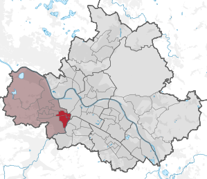
Löbtau is a district of Dresden and belongs to the Dresden city district Cotta . It borders the districts of Friedrichstadt , Cotta , Gorbitz , Naußlitz , Dölzschen , Plauen and Südvorstadt .
At times the largest independent rural community in Saxony was mentioned in a document as early as 1068 and is therefore mentioned for the first time 138 years before Dresden. As a suburb, it was incorporated into Dresden in 1903.
In the local colloquial language, the district is also referred to as Kuh-Löbte or Löbbe.
history
Löbtau was first mentioned in 1068 as “Liubituwa” (“lovely floodplain”) when the German King Heinrich IV gave two hooves from his property to the Meissen Monastery. Löbtau is one of the oldest documented settlements in the Elbe Valley. The history probably goes back to the origins of the Sorbs . The place was subordinate to the cathedral monastery of Meissen , but was handed over to the Electorate of Saxony in the course of the Reformation .
In the 19th century, the suburbs grew along with the neighboring city of Dresden . Löbtau had only 163 inhabitants in 1834, but the population multiplied over the next few decades and Löbtau became the largest rural community in Saxony. In 1875 the New Annenfriedhof was laid out. In 1881 Löbtau received a horse-drawn tram connection to Dresden, this line was electrified in 1900. There were several mills in the village along the Weißeritzmühlgraben . At the beginning of the 20th century, Löbtau was a factory and workers' suburb, for the most part with closed development. On January 1, 1903, it was incorporated into Dresden with around 39,000 inhabitants.
During the Second World War , there were building damage in Löbtau from bombing in 1944 and 1945, when the railway facilities ( Dresden-Friedrichstadt station and Wilsdruffer Vorstadt / coal station ) were attacked. Some streets were partially destroyed. Siemens'sche Glaswerk existed on Freiberger Strasse until 1945. After the destruction of Dresden city center on 13/14 February 1945 the largely intact Löbtau with the Kesselsdorfer Straße as the center became the most important business center in the west of Dresden. The remaining building fabric fell into disrepair as a remote quarter during the GDR era. Some areas were not rebuilt and left to decay. After the reunification of Germany in 1990, extensive renovation measures were carried out.
present
The district has a population of almost 20,000 and its social composition is mixed. Despite its increasing attractiveness, it is considered a simple to medium-sized residential area . The residential structure in Löbtau is characterized in particular by numerous old buildings and side streets with lots of green areas. Löbtau is considered quieter and greener than the Äußere Neustadt , Dresden's pub district . Due to the proximity to the TU Dresden and the favorable transport connections, Löbtau is also becoming increasingly attractive for students .
traffic
Löbtau is connected to Dresden city center and other parts of the city by tram lines 2, 6, 7 and 12 as well as bus lines 61, 62, 63, 85 and 90 of the Dresden public transport company . Otherwise, regional buses run by the Saxon Switzerland-Eastern Ore Mountains regional traffic in the direction of Freital (line A) and Kesselsdorf - Wilsdruff - Mohorn (line 333). Not far from the district are the S-Bahn stations Dresden-Plauen and (since 2004) Freiberger Straße, as well as the Dresden-Friedrichstadt station , which is only served by regional trains .
Industry
Sons and daughters
- Hans Gabriel Jentzsch (1862–1930), graphic artist, illustrator and caricaturist
- Johannes Hübschmann (1867–1930), lawyer, politician and Lord Mayor of Chemnitz from 1917 to 1930
- Karl Ernst Hänsel (1868–1947), etcher and painter
- Rolf Tillmann (1895–1985), painter
- Gustav Alfred Müller (1895–1978), painter and graphic artist
- Fritz Reuter (1896–1963), composer, musicologist and teacher
- Elfriede Lohse-Wächtler (1899–1940), painter
- Richard Klemm (1902–1988), cellist, composer and teacher
- Rudolf Braune (1907–1932), writer

Altlöbtau

Erlwein residential complex in Löbtau

City block at Saxoniastraße 18-28, was built 1920-1922.
.jpg)
.jpg)


See also
literature
- Friedrich Eduard Falland: History of the place Löbtau . Löbtau 1896 ( digitized as well as alternative digitized )
- Cornelius Gurlitt : Löbtau. In: Descriptive representation of the older architectural and art monuments of the Kingdom of Saxony. 24. Issue: Amtshauptmannschaft Dresden-Altstadt (Land) . CC Meinhold, Dresden 1904, p. 79.
- Matthias Stresow: Kuhlöbte in the middle of Dresden. In: Igeltour Dresden (ed.): Dresden - Looking for traces with Igeltour, Saxophon 2014, pp. 80-105, ISBN 978-3-943444-24-7
Web links
- Dresden districts: Löbtau
- Dresden-Löbtau
- Statistics on www.dresden.de: Löbtau-Nord (PDF; 364 kB), Löbtau-Süd (PDF; 362 kB)
- Löbtau in the Digital Historical Directory of Saxony
- Photos from Löbtau in the German Photo Library of the SLUB
Individual evidence
Districts in districts
Albertstadt |
Outer New Town |
Bubble joke |
Briesnitz |
Bühlau |
Coschütz |
Cotta |
Dobritz |
Dolzschen |
Dresden Heath |
Friedrichstadt |
Grid lake |
Gorbitz |
Gostritz |
Großzschachwitz |
Gruna |
Hellerau |
Hellerberge |
Hosterwitz |
Inner old town |
Inner New Town |
Johannstadt |
Kaditz |
Kaitz |
Kauscha |
Kemnitz |
Small plague |
Kleinzschachwitz |
Klotzsche |
Leaf guest |
Leipzig suburb |
Leuben |
Leubnitz-Neuostra |
Leutewitz |
Lockwitz |
Löbtau |
Loschwitz |
Luga |
Meusslitz |
Mickten |
Mockritz |
Naußlitz |
Nod |
Niederpoyritz |
Niedersedlitz |
Oberpoyritz |
Omsewitz |
Pieschen |
Pillnitz |
Pirnaische Vorstadt |
Plauen |
Prohlis |
Räcknitz |
Radeberger Vorstadt |
Reick |
Rochwitz |
Roßthal |
Seervorstadt |
Seidnitz |
Other |
Sporbitz |
Stetzsch |
Chasing |
Striesen |
Südvorstadt |
Tolkewitz |
Torna |
Trachau |
Trachenberg |
Übigau |
Wachwitz |
White deer |
Wilschdorf |
Wilsdruffer suburb |
Wölfnitz |
Zschertnitz |
Zschieren
Districts in localities
Altfranken |
Alt-Leuteritz |
Borsberg |
Brabuetz |
Cossebaude |
Cunnersdorf |
Eichbusch |
Eschdorf |
Friedersdorf |
Gönnsdorf |
Gohlis |
Gomlitz |
Gompitz |
Helfenberg |
Krieschendorf |
Langebrück |
Lausa |
Malschendorf |
Marsdorf |
Merbitz |
Mob treasure |
Neu-Leuteritz |
Niederwartha |
Oberwartha |
Ocher joke |
Cardboard box |
Pennrich |
Podemus |
Reitzendorf |
Rennersdorf |
Rockau |
Roitzsch |
Rossendorf |
Schönborn |
Schönfeld |
Schullwitz |
Steinbach |
Unkersdorf |
Whitish |
Weixdorf |
Zaschendorf |
Tariff
Statistical districts: Äußere Neustadt (Antonstadt) | Albertstadt | Bubble joke | Briesnitz | Bühlau / White Deer | Coschütz / Gittersee | Cossebaude / Mobschatz / Oberwartha | Cotta | Airport / industrial area Klotzsche | Friedrichstadt | Gönnsdorf / Pappritz | Gompitz / Old Franconia | Gorbitz-Nord / Neuomsewitz | Gorbitz-East | Gorbitz-Süd | Großzschachwitz | Gruna | Dresden Heath | Hellerau / Wilschdorf | Hellerberge | Hosterwitz / Pillnitz | Inner old town | Inner New Town | Johannstadt-North | Johannstadt-Süd | Kaditz | Kleinpestitz / Mockritz | Kleinzschachwitz | Klotzsche | Langebrück / Schönborn | Leaf guest | Leipzig suburb | Leuben | Leubnitz-Neuostra | Lockwitz | Löbtau-Nord | Löbtau-Süd | Loschwitz / Wachwitz | Mickten | Naußlitz | Niedersedlitz | Pieschen-Nord / Trachenberge | Pieschen-Süd | Pirnaische Vorstadt | Plauen | Prohlis-North | Prohlis-South | Radeberger Vorstadt | Räcknitz / Zschertnitz | Reick | Schönfeld / Schullwitz | Seervorstadt-Ost / Great Garden | Seidnitz / Dobritz | Chasing | Striesen-Ost | Striesen-Süd | Striesen-West | Südvorstadt-Ost | Südvorstadt-West | Tolkewitz / Seidnitz-Nord | Trachau | Weixdorf | Whitish | Wilsdruffer Vorstadt / Seevorstadt-West