
Niederwartha
|
Niederwartha
District of the state capital Dresden
Coordinates: 51 ° 5 ′ 36 ″ N , 13 ° 36 ′ 13 ″ E
|
|
|---|---|
| Height : | 101–230 m above sea level NN |
| Area : | 1.93 km² |
| Incorporation : | April 1, 1974 |
| Incorporated into: | Cossebaude |
| Postal code : | 01156 |
| Area code : | 0351 |
  Location of the Niederwartha district in Dresden
|
|
Niederwartha is a district of the Saxon capital of Dresden and, together with the neighboring districts Gohlis , New Leuteritz and Cossebaude the locality Cossebaude .
Location and landscape

The town of Niederwartha, with 433 inhabitants, is mostly located on the Elbe slope on Bundesstraße 6 between Dresden and Meißen on the edge of the valleys on the left Elbe . The landscape is characterized by numerous gardens, orchards and deciduous forests. Numerous marked hiking trails in the side valleys of the Elbe Valley lead in Tännichtgrund to Oberwartha and Weistropp , and in Amselgrund to Oberwartha and Cossebaude . On the Elbe Cycle Path you cross the bridge to Radebeul - Kötzschenbroda on the opposite side . On the banks of the Elbe in Niederwartha is 101 m above sea level. NN the lowest natural point in Dresden. The formerly independent village of Gruna on the Grunaweg also belongs to Niederwartha .
The Tännichtgrundbach forms the western district and city limits in sections, before it, like the Amselgrundbach , turns to the Lotzebach , which flows into the Elbe west of the two Elbe bridges.
history
In the 7th and 8th centuries, Slavs arrived in the sparsely populated area and built a settlement with defenses and a castle wall above today's Niederwartha on the castle hill. They called themselves " Nisans ". It was probably the Burgward "Woz" mentioned in various documents . The identifications with the Guodezi mentioned on September 22, 1045 in a royal document and with the Gvozdec castle mentioned by Cosmas of Prague in 1123 and 1087 and 1088 , whose name means “mountain forest” (cf. Czech. “Hvozd” for the Hochwald ).
Niederwartha was first mentioned in 1205, when a "Heinricus de Warta" (Heinrich von Wartha) appears in a document. The place name goes back to the Old High German "warta" and stands for a "settlement from which one lurks, spies out, looks out". In the 14th century the town of Gruna came into the possession of the Lords of Saalhausen and was thereby united with Niederwartha.
To protect against flooding, the residents of the Elbe bank built dams between 1765 and 1790. With the establishment of the Saxon-Bohemian Steamship Company in 1836, Niederwartha received its own steamship stop. After the construction of the railway road bridge in 1875, the car ferry was sold to the neighboring town of Gauernitz in 1877 . In the last days of the war on May 8, 1945, the Elbe bridge was blown up to prevent the Red Army from crossing the Elbe there . A passenger train crashed into the Elbe with the damaged 2nd track in July. In autumn 1945 the Elbe bridge was reconstructed for a track. The construction of a new double-track railway bridge on the old foundations with a footpath and cycle path through the Reichsbahn across the Elbe began in 1977 and ended in 1983.

The Niederwartha pumped storage plant was built from 1927 to 1930 on the left Elbe corridor of Kötzschenbroda , the district of Am Fährhaus . In 1945 it was dismantled after the war as a reparation payment, and reconstruction began in 1954 after the Radebeuler Weiherwiesen had been moved around to Niederwartha.
During the construction of the Black Pump – Freital gas pipeline through the Elbe in 1958, skeletons of the inhabitants who died of the plague in 1613 were found while digging a gas pipe trench .
In 1974 Niederwartha was incorporated into Cossebaude . With the dissolution of the district of Dresden , the community of Cossebaude and with it the district of Niederwartha came to the district of Meißen on January 1, 1996 . The incorporation of Cossebaude and thus also of the Niederwartha district into Dresden took place in 1997.
During the Elbe floods in August 2002 , the water in Niederwartha was about 1.90 m on federal road 6 .
In March 2006, construction began on a second Elbe bridge for the new state road 84 between Niederwartha and Meißen . The bridge, which was completed at the end of 2008, could only be opened to traffic in December 2011.
Attractions
- Niederwartha pumped storage plant with reservoir and its three 3 m thick downpipes.
- Dragging of planes at the entrance of the Tännichtgrund, natural monument
Personalities
- Gerhard von Keußler (1874–1949), composer, spent the last years of his life here
- Christoph Jentsch (1931–2015), geographer and Afghanistan expert, born in Niederwartha
- Wolfgang von Stetten (* 1941), politician, born in Niederwartha
economy
Until the middle of the 20th century there were three grocery stores, a baker, a butcher, a shoemaker, a steamboat landing stage, a ferry, two laundry rolls, a post office and two inns.
Today, in addition to the pumped storage plant, there is a road construction and civil engineering company, a mechanical engineering company (machining), a building services company (HLS-TGA), a hairdresser, a medieval adventure restaurant, a dining restaurant, a dance hall and a beer garden on the bike path. Another restaurant opened in early 2007 above the lower reservoir. A hotel is under construction.
traffic
The Niederwartha stop is on the Berlin – Dresden railway line .
photos

View of the upper and lower basins

Niederwartha with pumped storage plant

Niederwartha (front) with Oberwartha (middle) and Kesselsdorf (middle back)

View of Niederwartha and the reservoir from the road to Weistropp

View from above the Oberwarthaer Straße to parts of the village and to Coswig
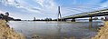
The newly built road bridge of the S84 connects Niederwartha and Kötzschenbroda


See also
Web links
Individual evidence
Districts in districts
Albertstadt |
Outer New Town |
Bubble joke |
Briesnitz |
Bühlau |
Coschütz |
Cotta |
Dobritz |
Dolzschen |
Dresden Heath |
Friedrichstadt |
Grid lake |
Gorbitz |
Gostritz |
Großzschachwitz |
Gruna |
Hellerau |
Hellerberge |
Hosterwitz |
Inner old town |
Inner New Town |
Johannstadt |
Kaditz |
Kaitz |
Kauscha |
Kemnitz |
Small plague |
Kleinzschachwitz |
Klotzsche |
Leaf guest |
Leipzig suburb |
Leuben |
Leubnitz-Neuostra |
Leutewitz |
Lockwitz |
Löbtau |
Loschwitz |
Luga |
Meusslitz |
Mickten |
Mockritz |
Naußlitz |
Nod |
Niederpoyritz |
Niedersedlitz |
Oberpoyritz |
Omsewitz |
Pieschen |
Pillnitz |
Pirnaische Vorstadt |
Plauen |
Prohlis |
Räcknitz |
Radeberger Vorstadt |
Reick |
Rochwitz |
Roßthal |
Seervorstadt |
Seidnitz |
Other |
Sporbitz |
Stetzsch |
Chasing |
Striesen |
Südvorstadt |
Tolkewitz |
Torna |
Trachau |
Trachenberg |
Übigau |
Wachwitz |
White deer |
Wilschdorf |
Wilsdruffer suburb |
Wölfnitz |
Zschertnitz |
Zschieren
Districts in localities
Altfranken |
Alt-Leuteritz |
Borsberg |
Brabuetz |
Cossebaude |
Cunnersdorf |
Eichbusch |
Eschdorf |
Friedersdorf |
Gönnsdorf |
Gohlis |
Gomlitz |
Gompitz |
Helfenberg |
Krieschendorf |
Langebrück |
Lausa |
Malschendorf |
Marsdorf |
Merbitz |
Mob treasure |
Neu-Leuteritz |
Niederwartha |
Oberwartha |
Ocher joke |
Cardboard box |
Pennrich |
Podemus |
Reitzendorf |
Rennersdorf |
Rockau |
Roitzsch |
Rossendorf |
Schönborn |
Schönfeld |
Schullwitz |
Steinbach |
Unkersdorf |
Whitish |
Weixdorf |
Zaschendorf |
Tariff