
Lotzebach
| Lotzebach | ||
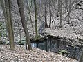
 Lotzebach near Rennersdorf on Lotzebachstrasse |
||
| Data | ||
| Water code | DE : 5373152 | |
| location | Saxony ( Germany ) | |
| River system | Elbe | |
| Drain over | Elbe → North Sea | |
| source |
Brabschütz , east of the Dresden-West motorway triangle 51 ° 3 ′ 43 ″ N , 13 ° 36 ′ 55 ″ E |
|
| Source height | 258 m above sea level HN | |
| muzzle |
Niederwartha , 200 m west of the two Elbe bridges Coordinates: 51 ° 5 ′ 46 ″ N , 13 ° 36 ′ 7 ″ E 51 ° 5 ′ 46 ″ N , 13 ° 36 ′ 7 ″ E |
|
| Mouth height | 100.2 m above sea level HN | |
| Height difference | 157.8 m | |
| Bottom slope | 24 ‰ | |
| length | 6.5 km | |
| Catchment area | 14.2 km² | |
| Left tributaries | ||
| Right tributaries | ||
The Lotzebach is a 6.5 km long left tributary of the Elbe in the west of the Saxon state capital Dresden . On its northward path it flows through the Dresden villages of Mobschatz , Oberwartha and Cossebaude . The river flows into the Elbe shortly before it leaves the Dresden city limits at the Kleditschgrundbach after more than 30 kilometers of river.
In its upper reaches it is in a near-natural to natural condition in the undeveloped areas. A total of around 0.9 kilometers of the stream are piped, the majority of which is in the lower reaches.
course
The Lotzebach rises in a hollow between the motorway triangle Dresden-West and Podemus . From there it flows for the first 400 meters in an east-northeast direction, but then turns to the northwest and after another 300 meters passes under the federal motorway 4 about 900 meters east-northeast of the center of the motorway triangle. To the north of the motorway bridge, the Lotzebach is connected to some rain retention basins , which, as part of the Dresden flood protection system, prevent the creek from swelling quickly during heavy rain events. In the further course between the Rennersdorf located to the west and the eastern Brabuetz it takes in a short distance from the left the Rennersdorfer Bach , which rises south of the named place , from the right the Brabschützer Dorfbach and again from the left the Rennersdorfer Dorfbach . From this section the Lotzebachtal is accompanied by the county road 6240 ( Schützenstraße - Lotzebachstraße - Talstraße ) to Cossebaude . The bank is therefore mostly secured on one side by means of a retaining wall.
Mouth of the Sickerbach

Hole mill

Forest mill

_03.jpg)
.jpg)
About 1.2 kilometers after the motorway bridge , the Lotzebach flows into the Sickerbach from the left, which drains a small part of the water from the Oberwartha reservoir (upper basin of the Niederwartha pumped storage plant ). As a result, the Lotzebach also has a connection to the Unkersdorfer Silberbach , which rises southeast of the motorway triangle near Unkersdorf, and the Unkersdorfer Feldbach, which feeds it shortly before the pre-blocking of the reservoir .
Less than 200 meters after the mouth of the Sickerbach is the Lochmühle , a former water mill . The grain mill, which was mentioned as early as 1400 and driven by the Lotzebach, was in operation until after the First World War. The forest mill , also a former water-powered grain mill , is around 200 meters further downstream . Both mills are among the technical monuments in Dresden . Hydraulic structures were dismantled after the flood of the century in 2002 , which led to an improvement in the structure of the water.
About 150 meters downstream of the Forest Mill takes the Lotze Bach left side of the (also listed ) Upper Warthaer Klostergut coming Klostergutbach up and turns into a northeasterly direction (first east-northeast, north-northeast later). The brook also enters the built-up area, takes on the left-hand Hässiger Bach , passes the district and district boundary from Oberwartha to Cossebaude and flows through the gardens of the residential buildings along the valley road, the appearance of its brook bed ranging from natural to piped. The Rauschebach , which flows past the Cossebaude mountain cemetery, joins the Friedhofsweg . About half a kilometer further on, on Weinbergstraße, the Lotzebach takes on the Jahnbach . The toboggan stream it feeds also rises in Cossebaude and has been regulated by a rainwater retention basin if necessary since 2002.
On the Berlin – Dresden railway line , a third of a kilometer after the mouth of the Jahnbach and not far from the Cossebaude train station , the Lotzebach bends 90 ° to the northwest and from then on runs parallel to the railway line in a paved, trapezoidal creek bed and piped in places. Originally, the stream, as it was still shown on maps around 1880, flowed further north, turned into the area of the Niederwartha reservoir, which was built later (lower basin of the pumped storage plant), and there it flowed into the Elbe.
In today's course, the Lotzebach crosses under Meißner Straße ( B 6 ) and is piped there at the reservoir. At the edge of the Cossebauder Park , around one kilometer after the 90 ° bend, it takes in the Amselgrundbach coming from the southwest on the left in the piped creek bed . The Amselgrund through which it flows forms the border between Cossebaude and Niederwartha and, like the Lotzebach valley, is one of the left- Elbe valleys . After just under another kilometer, the Lotzebach takes its most important tributary, the Tännichtgrundbach , on the left side of the Niederwarthaer Elbe bridges - formerly a tributary of the Elbe. Rising near the Dresdner Tor motorway service station , the one in Tännichtgrund forms the western city limits of Dresden in sections.
About 200 meters after the confluence of the Tännichtgrundbach, the Lotzebach flows into the Elbe.
Literature and further evidence
Footnotes
- ↑ a b c d e f g h i State capital Dresden, The Lord Mayor, Environment Agency (ed.): Water profile Lotzebach . ( Online as PDF ; 3.4 MB - as of July 13, 2012).
- ↑ a b Lotzebach in the themed city map of Dresden. State capital Dresden, accessed on November 12, 2019 .
- ↑ Lotzebachstrasse. In: dresdner-stadtteile.de. Accessed February 1, 2020 .
Web links
- Article Lotzebach in Stadtwiki Dresden