
List of districts and localities in Dresden
The city districts and localities in Dresden are administrative members in the urban area of the Saxon state capital.
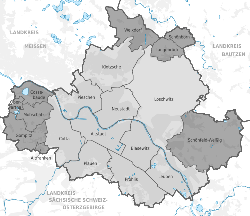
Overview
Since 1958 Dresden was divided into five city districts, namely center , north , east , south and west . According to § 32 of the Communal Constitution of the GDR (KomVerf) that came into force in 1990 and initially continued to apply as state law, urban districts could be set up as subordinate administrative bodies in independent cities, which was implemented in Dresden in 1991. In that year, ten smaller units were created from the five city districts, which should make it easier for residents to identify and bring them closer to the citizens.
The name city district was replaced by local office area in order to distinguish itself from the nomenclature of the GDR era. Since the municipal ordinance of the Free State of Saxony, which came into force in 1993, took over § 32 KomVerf with the same content, there was no break in the history of the local offices, the designation of which was now regulated in the main statute . With effect from September 13, 2018, the day of the public announcement of the corresponding amendment to the statutes, the term city district replaced the meanwhile term local office area. Accordingly, the local council, local office and local office manager became the new names city district council, city district office and city district office manager.
From 1997 to 1999, carried incorporation of ten villages, hamlets or formerly independent communities to Dresden. With the exception of Kauscha , which belongs to the Prohlis district , they were not incorporated into the local offices / districts and retained somewhat more extensive powers as so-called localities within the meaning of the Saxon municipal code. In addition to the ten city districts, the state capital also consists of nine localities.
The city districts are divided into 57 statistical city districts . The localities are also subdivided into statistical districts or combined into such, depending on their number of inhabitants. In the area of the localities there are seven statistical districts ( Weixdorf is the only locality that is exactly congruent with a statistical district). Thus there are a total of 64 statistical districts in Dresden.
Legend
- Map: Shows the location of the city district or the town within the Dresden city area.
- Status: Provides information about the status of the administrative unit as a city district or locality according to the main statute of the state capital Dresden § 31 and §§ 36–39.
- Name: States the name of the district or the town.
- Statistical district (s): Names the statistical district (s) in the city district or in the area of the town with the number and name.
- Official seat: states the official official name, then (if different) the name of the building and finally the district in which the official seat is located.
- Population: Indicates the number of residents who are registered with their main place of residence in the city district or in the locality.
- Area (hectares): Indicates the area of the city district or town in hectares.
- Population density (inh. / Km²): Indicates the population density of the city district or town in inhabitants per square kilometer.
City districts and localities in Dresden


See also
Web links
- City district offices and localities of Dresden on dresden.de
- City district offices and localities in the Dresden themed city map
References and footnotes
- ^ Law on the self-administration of the municipalities and districts in the GDR (municipal constitution 1990). In: www.verfassungen.de. Retrieved April 28, 2020 .
- ^ Stefan Alberti: Concession to incorporated places. New Dresden residents can also vote for local councils. In: Dresdner Latest News , May 18, 1999, p. 11
- ↑ Municipal code for the Free State of Saxony from April 21, 1993. In: REVOSax. Retrieved April 28, 2020 .
- ^ State capital Dresden (ed.): Dresden Official Journal. Edition 37/2018, pp. 29–31.
- ↑ Sections 65-69 of the municipal code for the Free State of Saxony. The historical version was valid from December 28th, 1996 to March 31st, 1997. In: REVOSax. Retrieved April 28, 2020 .
- ↑ dresden.de: Main statute of the state capital Dresden (PDF; 384 kB)
- ↑ a b c Population density by districts 1990 and 2019. (PDF; 279 KB) State capital Dresden, February 2020, accessed on June 17, 2020 .
- ↑ Dresden's localities. Retrieved June 17, 2020 .
- ↑ The seat of the city district office is in the statistical district 134 "Äußere Neustadt (Hoyerswerdaer Str.)". As the southern part of Antonstadt, this belongs to the statistical district of Innere Neustadt with Antonstadt-Süd . In terms of urban history, however, its area can be assigned to the district of Äußere Neustadt.
- ↑ a b Before the local office at that time (today: Stadtbezirksamt) moved from Fritz-Foerster-Platz 2 to Plauen town hall in 1996, the local office area at that time was called "Südvorstadt"; accordingly the local office was called that at first.
City districts (since 1991; until 2018: "local authority areas"): Old Town | Bubble joke | Cotta | Klotzsche | Leuben | Loschwitz | Neustadt | Pieschen | Plauen | Prohlis
Localities (since 1997/99): Old Franconia | Cossebaude | Gompitz | Langebrück | Mob treasure | Oberwartha | Schönborn | Schönfeld-Weißig | Weixdorf
Former City districts (until 1991): Middle | North | East | South | west