
Bühlau / White Deer
 with Rochwitz and Loschwitz-Nordost Statistical district No. 42 of Dresden |
|
|---|---|
  |
|
| Coordinates | 51 ° 3 '43 " N , 13 ° 50' 0" E |
| height | 195– 307 m above sea level NN |
| surface | 6.79 km² |
| Residents | 11,037 (Dec. 31, 2013) |
| Population density | 1625 inhabitants / km² |
| Post Code | 01324 |
| prefix | 0351 |
| Website | www.dresden.de |
| Borough | Loschwitz |
| Transport links | |
| Federal road |
|
| tram | 11 |
| bus | 61, 84, 226, 227, 228, 229, 261, 309 |
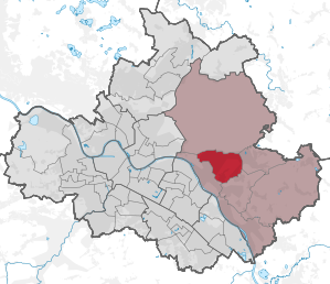
Bühlau / Weißer Hirsch with Rochwitz and Loschwitz-Nordost is a statistical district in the Dresden district of Loschwitz . It is located east of the city center on the Neustadt side of the Elbe.
location
The statistical district of Bühlau / Weißer Hirsch is surrounded in the north by the Dresdner Heide , in the east by Weißig , in the southeast by Gönnsdorf / Pappritz and in the southwest and west by Loschwitz / Wachwitz .
The boundaries of the district are formed by the edge of the Dresdner Heide, the outer city boundary, which was valid until 1999, and the Dresden Elbe slopes, for example on the line Kuckuckssteig-Ulrichstraße-Weinleite- Mordgrundbrücke . Bühlau / Weißer Hirsch is therefore completely outside the Elbe valley in the transition area to the Schönfeld highlands and the Radeberger Land .
structure
The statistical district includes the districts or districts of Bühlau , Weißer Hirsch and Rochwitz as well as the northeastern part of the Loschwitz district and the Quohren district , which belongs to the Bühlau district. It is divided into the following nine statistical districts :
- 421 white stag
- 422 Loschwitz-Nordost (Rißweg)
- 423 Loschwitz-Nordost (Am Weißen Adler)
- 424 Bühlau (Neubühlauer Str.)
- 425 Bühlau (Neukircher Str.)
- 426 Bühlau (Ullersdorfer Str.)
- 427 Alt-Bühlau / Quohren
- 428 Rochwitz
- 429 Neu-Rochwitz
traffic
The most important streets in the district are the Bautzner Landstrasse, on which the Bundesstrasse 6 and tram line 11 run, the Grundstrasse leading to the Blauer Wunder ( State Road 167) and the Ullersdorfer Landstrasse to Radeberg (State Road 181). In Bühlau / Weißer Hirsch there are also several city bus and regional bus routes . The statistical district has a total of 12 tram and 30 bus stops. In the west of the district is also the mountain station of the funicular leading to Loschwitz .
Web links
Statistical districts: Äußere Neustadt (Antonstadt) | Albertstadt | Bubble joke | Briesnitz | Bühlau / White Deer | Coschütz / Gittersee | Cossebaude / Mobschatz / Oberwartha | Cotta | Airport / industrial area Klotzsche | Friedrichstadt | Gönnsdorf / Pappritz | Gompitz / Old Franconia | Gorbitz-Nord / Neuomsewitz | Gorbitz-East | Gorbitz-Süd | Großzschachwitz | Gruna | Dresden Heath | Hellerau / Wilschdorf | Hellerberge | Hosterwitz / Pillnitz | Inner old town | Inner New Town | Johannstadt-North | Johannstadt-Süd | Kaditz | Kleinpestitz / Mockritz | Kleinzschachwitz | Klotzsche | Langebrück / Schönborn | Leaf guest | Leipzig suburb | Leuben | Leubnitz-Neuostra | Lockwitz | Löbtau-Nord | Löbtau-Süd | Loschwitz / Wachwitz | Mickten | Naußlitz | Niedersedlitz | Pieschen-Nord / Trachenberge | Pieschen-Süd | Pirnaische Vorstadt | Plauen | Prohlis-North | Prohlis-South | Radeberger Vorstadt | Räcknitz / Zschertnitz | Reick | Schönfeld / Schullwitz | Seervorstadt-Ost / Great Garden | Seidnitz / Dobritz | Chasing | Striesen-Ost | Striesen-Süd | Striesen-West | Südvorstadt-Ost | Südvorstadt-West | Tolkewitz / Seidnitz-Nord | Trachau | Weixdorf | Whitish | Wilsdruffer Vorstadt / Seevorstadt-West