
Großzschachwitz (statistical district)
 with Sporbitz Statistical district No. 64 of Dresden |
|
|---|---|
  |
|
| Coordinates | 51 ° 0 '0 " N , 13 ° 50' 44" E |
| height | 110- 120 m above sea level. NN |
| surface | 2.22 km² |
| Residents | 6296 (Dec. 31, 2013) |
| Population density | 2836 inhabitants / km² |
| Post Code | 01259 |
| prefix | 0351 |
| Website | www.dresden.de |
| Borough | Leuben |
| Transport links | |
| Train | S1, S2 |
| tram | 2 |
| bus | 65, 88 |
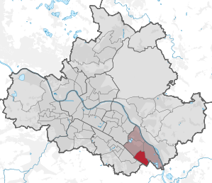
Großzschachwitz with Sporbitz is a statistical district in the Dresden district of Leuben . It is located southeast of the city center on the left or old town side of the Elbe.
structure
Almost the entire district of Großzschachwitz , Sporbitz and small parts of the districts of Niedersedlitz and Großluga belong to the statistical district . It is divided into the following six statistical districts :
- 641 Großzschachwitz (Alte Str.)
- 642 Großzschachwitz (Rathener Str.-North)
- 643 Großzschachwitz (Rathener Str.-Mitte)
- 644 Großzschachwitz (Rathener Str.-Süd)
- 645 Großzschachwitz (Schweizstrasse)
- 646 Sporbitz
location
The statistical district of Großzschachwitz is surrounded in the northeast by Kleinzschachwitz , in the northwest by Leuben and in the southwest by Niedersedlitz . Heidenau lies to the southeast .
The boundaries of the district are formed on the east side by an old Elbarm. Försterlingstrasse marks the north-west border and the Dresden – Děčín railway line marks the south-west border. In contrast, the city limits of Dresden run in the southeast.
traffic

The most important streets in the district are the Pirnaer Landstrasse, an entry and exit road to Pirna , as well as the Bahnhofstrasse. Both cross in the north of the district. They are used by various bus lines of the Dresden public transport company , which have a total of 15 stops in the district.
In the south of the district is the Dresden- Zschachwitz stop , which is connected to two S-Bahn lines .
Web links
Statistical districts: Äußere Neustadt (Antonstadt) | Albertstadt | Bubble joke | Briesnitz | Bühlau / White Deer | Coschütz / Gittersee | Cossebaude / Mobschatz / Oberwartha | Cotta | Airport / industrial area Klotzsche | Friedrichstadt | Gönnsdorf / Pappritz | Gompitz / Old Franconia | Gorbitz-Nord / Neuomsewitz | Gorbitz-East | Gorbitz-Süd | Großzschachwitz | Gruna | Dresden Heath | Hellerau / Wilschdorf | Hellerberge | Hosterwitz / Pillnitz | Inner old town | Inner New Town | Johannstadt-North | Johannstadt-Süd | Kaditz | Kleinpestitz / Mockritz | Kleinzschachwitz | Klotzsche | Langebrück / Schönborn | Leaf guest | Leipzig suburb | Leuben | Leubnitz-Neuostra | Lockwitz | Löbtau-Nord | Löbtau-Süd | Loschwitz / Wachwitz | Mickten | Naußlitz | Niedersedlitz | Pieschen-Nord / Trachenberge | Pieschen-Süd | Pirnaische Vorstadt | Plauen | Prohlis-North | Prohlis-South | Radeberger Vorstadt | Räcknitz / Zschertnitz | Reick | Schönfeld / Schullwitz | Seervorstadt-Ost / Great Garden | Seidnitz / Dobritz | Chasing | Striesen-Ost | Striesen-Süd | Striesen-West | Südvorstadt-Ost | Südvorstadt-West | Tolkewitz / Seidnitz-Nord | Trachau | Weixdorf | Whitish | Wilsdruffer Vorstadt / Seevorstadt-West