
Yuri Gagarin ring
.jpg)
The Juri-Gagarin-Ring is a 2300 meter long ring road that surrounds the core of Erfurt's old town in the south and east. The street was laid out in 1898 after plans had been made for it under Lord Mayor Richard Breslau . Since 1964 it has been named after the Soviet spaceman Yuri Gagarin .
Naming
After the ring was created, it was given different names on the sections in 1903. The northern part up to Hospitalplatz became Johannesring , the eastern part between Hospitalplatz and Trommsdorffstrasse Krämpferring , the southeastern part between Trommsdorffstrasse and Bahnhofstrasse Regulatorring , the southern part between Bahnhofstrasse and Löberstrasse Löberring and the southwestern part from Löberstrasse to Karl-Marx-Platz Kartäuserring called. This name was given until 1951. At that time, the sections were grouped under the name Mao-Tsetung-Ring after the Chinese dictator Mao Tsetung . In 1964 the name was changed to Juri-Gagarin-Ring, because at that time people broke with people like Stalin and Mao Tsetung. Juri Gagarin visited Erfurt in 1963, when he was staying at the Erfurt court .
Origin and location in the urban space


The course of today's ring traces the course of the oldest, inner city wall of Erfurt from around 1000. The Wilde Gera , an arm of the Gera in the Erfurt city area , ran parallel to this wall until 1898 . At that time they wanted to avert the risk of flooding in the old town and dug the flood ditch . It runs parallel to the Wilde Gera about 200 meters further outside and can drain away much more water than the Wilde Gera. It was then filled in using the structure of the demolished city wall and the ring road was built on it, which relieves the city center.
The ring begins at the inner Johannestor in the north of the city. There it is connected to the valley junction via Johannesstraße , where the Erfurt city ring crosses the road to Ilversgehofen (further to Mittelhausen and Sömmerda via Magdeburger Allee ). Next he crosses Franckestrasse, today's state road to Sömmerda and Stotternheim north of Erfurt. This is followed by the intersection with Krämpferstraße, which leads over Leipziger Straße to Kerspleben and Buttelstedt . In the south-east, the direction of the ring changes in a wide arc from north-south to east-west; This is where Meyfartstrasse crosses, Trommsdorffstrasse, which leads to the Schmidstedter node on the city ring, and Bürgermeister-Wagner-Strasse, which leads to the main train station and bus station. This is followed by the intersection with Bahnhofstrasse , which serves as a pedestrian zone and tram route. The Löberstrasse begins further to the west at the Ring and leads to Arnstadt . The western end of the ring is Karl-Marx-Platz , which is connected to Gothaer Platz on the city ring via the Dalbergsweg – Walkmühlstraße – Bonifaciusstraße street . The federal highways to Nordhausen and Gotha begin there .
The Juri-Gagarin-Ring, which is interrupted by ten traffic lights, is of enormous importance for inner-city traffic to this day. Long-distance traffic, however, can switch to the Erfurt city ring and the Erfurt ring .
history
During the construction of the ring, some old houses in this area were demolished and replaced by larger new buildings in the style of historicism . Later, some buildings from the Bauhaus and New Objectivity followed . This "old" Juri-Gagarin-Ring is best visible today between Meyfartstrasse and Bahnhofstrasse.
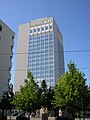
The Juri-Gagarin-Ring underwent the most radical structural changes in the 1960s when it was expanded into a main road based on the Soviet model. Entire old town areas, for example the Krmpferviertel, were demolished. They were replaced by parking areas, a street widening and prefabricated buildings with more living space than the old houses could offer. The Ringhotel , the Interhotel Kosmos (today Radisson Blu ), the high-rise on Hospitalplatz and the high-rise buildings on Krämpfertor (No. 126 A, B and C) were built as point high-rise buildings . In addition, three eleven-storey prefabricated buildings, each about 100 meters long, were erected at the Krämpfertor. There is also a 250-meter and two 200-meter-long eleven-storey prefabricated building at Löbertor.
The New Synagogue , the Carthusian Monastery and the Museum of Thuringian Folklore Erfurt are also located on the Ring .
In the early 1980s, specific plans for closing the ring were made . Starting from the Johannestor, the street Am Hügel was to be expanded and the ring continued in the extension of Augustinerstraße over the Lehmannsbrücke , through the Pergamentergasse , over the Domplatz and through the Brühler Garten to Karl-Marx-Platz . This would have meant the demolition of numerous houses, especially the historic Andreasviertel , which is why a citizens' initiative was formed in 1986 which, together with monument conservationists, organized the exhibition Stadtgerechter Verkehr - traffic-compatible city in Michaeliskirche in May 1987 . Because of this protest and not least in the course of the fall of the Wall , the plans were finally shelved.
Buildings on the Ring
Before the First World War

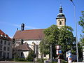
Catholic Apostolic Church on the St. John's Wall

Reglerkirche on the corner of Bahnhofstrasse (1130)
Neuwerkskirche on Karl-Marx-Platz (1735)

Large hospital , now a folklore museum (1547)

Press club on Karl-Marx-Platz

Building of the printing progress


Time of the Weimar Republic

Deutsche Bank on the corner of Bahnhofstrasse

Reichsbank. Today the Federal Railway Authority, Erfurt office on the corner of Trommsdorffstrasse

Trading houses on the Ring between Meyfarthstrasse and Trommsdorffstrasse

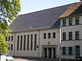
Post office (today Telekom) on the corner of Bürgermeister-Wagner-Strasse (1924)


GDR time
New Synagogue (1952) on the corner of Hopfengasse

House of Social Services (1955) on the corner of Franckestrasse
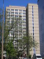
Hospitalplatz high-rise

High-rise buildings No. 126 A, B and C at the Krämpfertor
Apartment block on the corner of Krämpferstrasse

Housing disc C at Löbertor (1984)
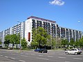
Hotel Radisson on the corner of Krmpferstrasse

Tower of the newspaper Thüringer Allgemeine on Weißfrauengasse

1972: View from the skyscrapers 126 A, B, C northwards along the ring

Krämpfertor 1972


After 1990

Thuringia house on the corner of Johannesstrasse

Forum I at Thomaseck


Web links
Coordinates: 50 ° 58 ′ 43 ″ N , 11 ° 2 ′ 15 ″ E