
Aker Brygge
| Aker Brygge Oslo |
|||
|---|---|---|---|
|
|||
| Coordinates | 59 ° 55 ' N , 10 ° 43' E | ||
| Basic data | |||
| Country | Norway | ||
| Oslo | |||
| city | Oslo | ||
| ISO 3166-2 | NO-03 | ||
| district | Frogner | ||
| Residents | 900 (October 2011) | ||
| founding | 1986 | ||
 Aker Brygge & Tjuvholmen
|
|||

Aker Brygge is a district and shopping center in the Frogner district of central Oslo . According to Dagens Næringsliv, it is one of the best - and most expensive - office spaces in the last 25 years. Around 6,000 people work in Aker Brygge every day and around 900 live in this area.
Limits
Aker Brygge is located on Pipervika Bay , by the Oslofjord . It has a clearly structured demarcation through the following streets: Dokkveien in the east, Munkedamsveien (Ring 1) in the north and the nameless path to Filipstadtkai in the west. Aker Brygge thus borders Vika in the east and north, Filipstadt in the west, Tjuvholmen in the southwest and the Oslofjord in the south.
History and Development
Aker Brygge is located on the former yard of Akers mekaniske verksted AS , which was closed in 1982. The former company was founded in 1854 when the area was still known as Holmen . Since the beginning of the early 18th century, some industrial companies have been established here and urban development has emerged.
Aker Brygge's expansion was carried out in four stages by the real estate company Aker Eiendom AS . Part of the old industrial buildings had to be demolished, but most of the large factory buildings were converted into office space. The first construction phase was completed in 1986 by the Telje-Torp-Aasen architectural office . In 1998 the fourth and final stage was completed with the new construction of the Storebrands insurance company on Munkedamsveien . The entire building mass covers 260,000 m².
Aker Brygge today
Today the district is a meeting place for entertainment, gastronomy and shopping tours and is visited by almost 12 million people every year. There are around 70 shops and 40 cafés, restaurants, bars and nightclubs here. In addition to the residential and office space that has been created, the Felix Kino and Latter / Standup Norge have also moved here.

Transport links
The stops of tram line 12 and various bus routes open up Aker Brygge. The Aker Brygge car park ( Europark ) has space for 907 vehicles. In front of it is Norway's largest parking lot for electric cars. There is also a train station with a subway connection near the National Theater . The small boat harbor, Herbern Marina , and the terminal for ferries to Nesodden can be reached in a few minutes on foot .
gallery

Aker Brygge with town hall
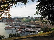
Aker brygge harbor
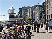
promenade

former district "Holmen" before the construction of Aker Brygge

Bryggetorget

Latter
.jpg)


literature
- Pia Brodahl: Aker Brygge 1985–1990. Byminner, 3/2008, pp. 50–59 ( Norwegian )
Web links
- Aker Brygge - Official Website (Norwegian, English)
Individual evidence
- ↑ Statuses er truet DN.no (April 27, 2010)
- ↑ Tjuvholmen - de styrtrikes nye nabolig E24 (October 11, 2011)