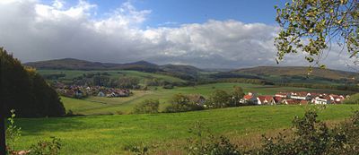
Elnhausen-Michelbacher depression
The Elnhausen-Michelbacher Senke is a valley basin running in north-south direction in the extreme northeast of the Gladenbacher Bergland west of Marburg in Central Hesse . It not only separates the up to 498 m high Damshausen peaks , up to 412 m high in the immediate western vicinity, from the adjoining Marburger Ridge to the east, up to 370 m high , but also the main natural unit groups Westerwald (32) and West Hessian Uplands (34).
The valley is named after the western Marburg suburbs of Elnhausen and Michelbach .

geography
Location and places
To the north, the Elnhausen-Michelbacher Senke, natural area 320.11, is bounded by the Lahn valley , which here is already part of the Wetschaft-Senke natural area (345.0) and thus the main unit of Burgwald (345). The southern dividing line to the Salzbödetal (320.12) is the watershed between the lower reaches of the Allna and that of the Salzböde or, further east, the Wenkbach .
From north to south (east) the Marburg suburbs Michelbach , Dagobertshausen , Elnhausen , Hermershausen , Haddamshausen and Cyriaxweimar lie in the valley. Weiershausen and Allna (municipality of Weimar ) are to the south and the Gladenbacher districts of Friebertshausen and Rüchenbach are located in the extreme southeast .

Rivers
Since the saddle between the 412 m high Hungert ( Damshäuser Kuppen ) and the 370 m high Vogelheerd ( Marburger Ridge ) is only 1 to 2 km away from the Lahn and with (at the deepest point) about 270 m above sea level the valley floor further south clearly towering above, only a few very short streams in the north flow directly into the Lahn . The only village in this partial depression is Michelbach.
In contrast, the vast majority of all rivers flow into the Lahn via the Allna , which flows eastwards in the extreme south . The central flowing water is the Elnhauser Wasser , which runs completely in the depression until it flows into the lower reaches of the Ohe , which in turn flows into the Allna after a few hundred meters.
Also worth mentioning are the Waltersbach , which flows into the Elnhausener Wasser in Elnhausen from the west (Damshäuser Kuppen), as well as the Wehrshäuser Bach (to the Elnhauser Wasser) and the Cyriaxweimarer Bach (to the Allna), the latter two rivers from the Marburg Ridge in the east.
use
Large parts of the valley basin are used for agriculture, while only a smaller part is forested. The northern half, from about the settlement area of Elnhausen, is almost entirely free of forests.
mountains
As a typical valley basin, the Elnhausen-Michelbacher Senke hardly has any significant elevations. Since its southern border to the Salzbödetal is a watershed , in the center of this seam between Hermershausen, Allna and Haddamshausen there are some wooded elevations around the 310 m high mountain Schneid , further to the southwest an unnamed, 326 m high mountain north of Willershausen . The only elevation that really lies in the interior of the depression is the Rote Scheid , a 302 m high north-east foothill of the Randkuppe Hungert beyond (= north) the state road 3092 (Marbach-Caldern).
In contrast, elevations in the immediate vicinity can be found at the eastern Damshausen peaks and in the Marburg Ridge .
Web links
- Map / aerial photo of the Elnhausen-Michelbacher Senke with surrounding elevations and rivers / placemarks ( Google Earth required)