Koenigshofen (Niedernhausen)
|
Koenigshofen
Community Niedernhausen
|
|
|---|---|
| Coordinates: 50 ° 9 ′ 47 ″ N , 8 ° 18 ′ 14 ″ E | |
| Height : | 295 m above sea level NN |
| Area : | 2.73 km² |
| Residents : | 1900 (2003) |
| Population density : | 696 inhabitants / km² |
| Incorporation : | 1st October 1971 |
| Postal code : | 65527 |
| Area code : | 06127 |
|
Königshofen from Schäfersberg
|
|
Königshofen has been part of the community of Niedernhausen in the Rheingau-Taunus district in southern Hesse since 1971 and is located in the Rhine-Taunus nature park .
Geographical location

Königshofen is located in the wooded Hohe Taunus on the western slope of the Daisbach valley , the deepest cut through the Taunushauptkamm , at a height of 295 meters. In the west, the Zieglerkopf towers above the town as an extension of the Hohe Kanzel (height 597 meters). Beyond the Daisbach , opposite it, in the northeast, is the 517-meter-high hill, which in various directions includes the mountain spurs Eselskopf, Hohler Stein, Buchwaldskopf and Nickel .
The most important north-south connections that cross the Taunus are bundled between these elevations in the Königshofen area: the Main-Lahn-Bahn , the Bundesautobahn 3 and the high-speed line Cologne-Rhine / Main .
The development of Königshofen is limited in the west by the federal highway 3 and in the east by the route of the Main-Lahn-Bahn to a width of about 300 meters. To the south and south-east, the development imperceptibly merges with that of the core town of Niedernhausen.
The district essentially comprises the slopes west of the Daisbach and north of the Theissbach , which flows through the nature reserve and FFH area Theiss Valley from Niedernhausen . The highest point of the district is on the eastern flank of the Zieglerkopf at a height of 440 meters. The Niedernhausen tunnel on the high-speed line to Cologne is located below this point .
history
The oldest surviving documentary mention as Kunegishove points to the beginning of the 13th century. It is possible that a Carolingian royal court was located here as an early administrative center. In 1283 Gottfried III renounced von Eppstein to Count Adolf von Nassau to any right in Cunegeshoven . From this time until 1866 Königshofen was one of the Nassau ancestral lands.
After the Thirty Years War , Königshofen was almost completely depopulated. Count Johannes von Nassau-Idstein settled Walloon families from the Principality of Liège in Königshofen. This made Königshofen one of the few places with a Catholic population in Protestant Nassau. There are still numerous descendants of these immigrants today.
There were once three mills at Daisbach and Theißbach (Wiesen- or Queckenmühle; Hartz- or Hoffmannsmühle, both of which can be found in the church records under the names Ober- and Unterkönigshofener Mühle) and the mill at the Hirschsuhle, popularly known as Lumpenmühle called. cs
At the time of the Duchy of Nassau , Königshofen belonged to the Idstein office . After the annexation by Prussia, it was assigned to the Untertaunuskreis in the Wiesbaden administrative district in 1867 and to the newly formed Main-Taunus-Kreis in 1928 .
In the course of the regional reform in Hesse , the municipalities of Königshofen and Niedernhausen merged on October 1, 1971 to form the new municipality of Niedernhausen. The seat of the municipal administration became Niedernhausen. There were other changes in the course of the territorial reform. The community of Niedernhausen was enlarged by four districts and incorporated into the newly formed Rheingau-Taunus district . Local districts with local advisory councils and local councilors were formed for all districts . At the same time, Bad Schwalbach had become a district town again for the residents of Königshofen after 50 years .
Culture
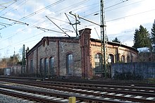
For the cultural monuments of the district see the list of cultural monuments in Königshofen . The northern half of the Theiss valley bridge is in the Königshofen area. It dominates the landscape and is a listed building. A water tower, also listed as a historical monument, and a locomotive shed in the station area also belong to Königshofen. Both were converted for residential purposes.
coat of arms
The former municipality of Königshofen has only had one seal in its history, which of course shows a white royal court with red roofs on a blue background for the place name. Between two towers there is a golden crown, which served as a template for a proposed coat of arms. The proposed coat of arms shown on this page was replaced by the former municipal seal by resolution of the local council.
traffic
Königshofen is located on the K 705 district road, which leads from the neighboring town of Niedernhausen to the north-west in the direction of Niederseelbach . The Niedernhausen station as S-Bahn-terminus of the line S2 is just 800 meters from the town center Königshofen. It is three kilometers to the Niedernhausen junction of the motorway.
Web links
- Königshofen district. In: Internet presence. Niedernhausen community
- Königshofen, Rheingau-Taunus-Kreis. Historical local dictionary for Hessen. In: Landesgeschichtliches Informationssystem Hessen (LAGIS).
- Literature about Königshofen in the Hessian Bibliography
Individual evidence
- ↑ Königshofen, Rheingau-Taunus-Kreis. Historical local dictionary for Hessen. (As of October 16, 2018). In: Landesgeschichtliches Informationssystem Hessen (LAGIS).
- ^ Federal Statistical Office (ed.): Historical municipality directory for the Federal Republic of Germany. Name, border and key number changes in municipalities, counties and administrative districts from May 27, 1970 to December 31, 1982 . W. Kohlhammer, Stuttgart / Mainz 1983, ISBN 3-17-003263-1 , p. 370 .
- ↑ main statute. (PDF; 90 kB) §; 6. In: Website. Niedernhausen community, accessed February 2019 .


