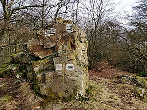
High pulpit
| High pulpit | ||
|---|---|---|
|
Summit stone |
||
| height | 591.8 m above sea level NHN | |
| location | at Königshofen ; Rheingau-Taunus-Kreis , Hessen ( Germany ) | |
| Mountains | Taunus | |
| Dominance | 9.8 km → Hohe Wurzel | |
| Notch height | 170 m ↓ Iron Hand | |
| Coordinates | 50 ° 9 '41 " N , 8 ° 15' 53" E | |
|
|
||
The Hohe Kanzel is 591.8 m above sea level. NHN high elevation in the German low mountain range Taunus . It is located near Königshofen in the Niedernhausen municipality in the Rheingau-Taunus district of Hesse . Its name is probably derived from a rock group on the summit region that resembles a pulpit.
geography
location
The Hohe Kanzel rises as part of the Taunus main ridge in the Rhein-Taunus Nature Park and in the municipality of Niedernhausen . Its summit is 2 km east-south-east of Wildpark , a residential area of the 1.7 km north-west Engenhahn district , 2.3 km north-east of the Niederseelbach district , 2.7 km west of the Königshofen district , 3.9 km northwest of Naurod , a district of Wiesbaden , and 3.7 km east-northeast of Platte , a residential area of Wehen . To the north of the elevation, near Engenhahn, is the source of the Daisbach , into which the Theissbach , which rises in the southwest, flows east-southeast of the elevation in Niedernhausen .
Natural allocation
The Hohe Kanzel belongs to the natural spatial main unit group Taunus (No. 30) and in the main unit Hoher Taunus (301) to the subunit Wiesbadener Hochtaunus (301.2). The landscape leads south into the natural area Georgenborn Nauroder Slopes foot (301.20) and to the east into the natural area Königshofer Pforte (301.21). To the north it falls into the subunit Eastern Aartaunus (304.3), which is part of the main Western Hintertaunus (304) unit.
Mountain height
The Hohe Kanzel is 591.8 m high. Almost 800 m west-southwest of its summit is a 592.3 m high nameless point in the direction of the Hoher Wald .
Protected areas
Parts of the fauna-flora-habitat area beech forests stretch across the southern flank to the summit region of the wooded Hohe Kanzel north of Wiesbaden (FFH No. 5815-306; 41.243 km² ). The FFH area of Theißtal von Niedernhausen with adjoining areas extends along its southern flank (FFH No. 5815-303; 82.51 ha ) and the nature reserve Theiss Valley von Niedernhausen ( CDDA No. 165875; designated 1993; 52.65 ha) . Parts of the landscape protection area City of Wiesbaden extend to the southwest and south foot (CDDA no. 555513808; 2010; 133.2864 km²).
Possibility of viewing
There used to be an observation tower on the summit of the Hohe Kanzel . Below that, a clearing in the upper part of a corridor extends towards the south-southeast, which opens up a view of the Upper Rhine Plain - including Wiesbaden and Mainz .
Traffic and walking
The federal motorway 3 runs over the lower part of the east-northeast flank of the Hohe Kanzel . To the north past the elevation, the state road 3273 runs through Engenhahn , from which the district road 705, which is laid out below the A 3 and runs through Königshofen, branches off in Niederseelbach . The Main-Lahn-Bahn runs roughly parallel to this . The 2,765 m long Niedernhausen tunnel of the high-speed Cologne – Rhine / Main line runs through the east-northeast flank of the elevation . The German Limes Cycle Path runs past Engenhahn to the north .
See also
Individual evidence
- ↑ a b c d e Map services of the Federal Agency for Nature Conservation ( information )
- ↑ Summit in the Taunus by dominance and prominence , on highrisepages.de
- ↑ Heinrich Müller-Miny, Martin Bürgener: Geographical land survey: The natural spatial units on sheet 138 Koblenz. Federal Institute for Regional Studies, Bad Godesberg 1971. → Online map (PDF; 5.7 MB)


