Heisebeck
|
Heisebeck
community Wesertal
|
|
|---|---|
| Coordinates: 51 ° 35 ′ 12 ″ N , 9 ° 39 ′ 23 ″ E | |
| Height : | 187 m above sea level NHN |
| Area : | 6.53 km² |
| Residents : | 530 approx. |
| Population density : | 81 inhabitants / km² |
| Incorporation : | August 1, 1972 |
| Incorporated into: | Upper Weser |
| Postal code : | 34399 |
Heisebeck is a district in the east of the Wesertal municipality in the Kassel district in northern Hesse .
Geographical location
The village of Heisebeck is located in the northernmost part of Northern Hesse, right on the border with Lower Saxony . It is located in the Weserbergland on the northern edge of the Bramwald and on the south-eastern edge of the Kiffing ridge , around 4.5 km (as the crow flies ) east of Oedelsheim , 7 km east of Gieselwerder ( parts of the Weser valley on the Weser ), 8 km south of Uslar , 18 km west-northwest of Göttingen and 30 km north-northeast of Kassel (all information as the crow flies).
Heisebeck's direct neighbors are the Hessian Arenborn in the north-northwest and the Lower Saxony villages of Offensen in the northeast and Fürstenhagen in the southwest. The Arenborn and Hessenbach creeks flow through the village and belong to the catchment area of the Schwülme , which runs not far to the northeast .
history
Heisebeck was first mentioned in a document in 1151 as "hasbike", but it may be older. In 1585 the place comprised 29 households, 56 in 1747. The population from the end of the 17th century is indexed through a local family book .
An older Protestant church is said to be "very old and without an organ" in 1835, with the fact that it was "significantly improved" in 1828. Today's Protestant church was built in 1885 by the Kassel architect Werner Narten . The vaulted nave of four bays is entered through a western tower and then looks into the somewhat lower rectangular choir. The pulpit, the altar, behind this an artistic glazing in a three-lane tracery window and the organ come from the construction period.
On August 1, 1972, as part of the regional reform in Hesse , the previously independent town was attached to the municipality of Oberweser by virtue of state law , which had already been formed a good year earlier through the amalgamation of several towns and whose administrative seat was Gieselwerder . This in turn merged with Wahlsburg on January 1, 2020 to form the municipality of Wesertal.
For the listed cultural monuments of the place see the list of cultural monuments in Heisebeck .
coat of arms
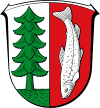
Blazon : "In a shield split by silver and red, a green fir tree on a green ground in front in silver and a fallen silver trout in red at the back."
The coat of arms of the municipality of Heisebeck in the then Hofgeismar district was approved by the Hessian Minister of the Interior on June 24, 1969 . It was designed by the Bad Nauheim heraldist Heinz Ritt .
Economy and Infrastructure
The place is accessed by several state and district roads. The next train station is Offensen on the Bodenfelde -Göttingen line.
Even though Heisebeck is in a rural region, agriculture and forestry now only play a subordinate role.
There are also no industrial companies on site, so that, among other things, the service sector with smaller craft businesses and tourism with over 50 guest beds are economically important today.
Personalities
Honorary citizen
- 1895 Otto von Bismarck (1815–1898), Reich Chancellor
Sons and daughters of the place
- Johann Friedrich Klemme (born February 3, 1792 in Heisebeck, † before 1845), Ackermann, headmaster and coachman; Stepfather of the pastor and biological son Jérôme Bonapartes , Hieronymus Lüdeke (born November 15, 1808 in Göttingen , † March 18, 1890 in Dassensen ; also Lüdecke).
- Fritz Grebe (1850–1924), painter
literature
- Klaus Kunze : Ortssippenbuch Heisebeck and Arenborn. Uslar 2000. ISBN 978-3-933334-08-4
- Literature on Heisebeck in the Hessian Bibliography
Web links
- District Heisebeck on the website of the municipality of Oberweser.
- Heisebeck. Info. In: www.heisebeck.de. Private website
- Heisebeck, Kassel district. Historical local dictionary for Hessen. In: Landesgeschichtliches Informationssystem Hessen (LAGIS).
Individual evidence
- ↑ a b The location on the Oberweser municipality's website , accessed in August 2016.
- ↑ Law on the reorganization of the districts of Hofgeismar, Kassel and Wolfhagen (GVBl. II 330-17) of July 11, 1972 . In: The Hessian Minister of the Interior (ed.): Law and Ordinance Gazette for the State of Hesse . 1972 No. 17 , p. 225 , § 12 ( online at the information system of the Hessian state parliament [PDF; 1,2 MB ]).
- ^ Federal Statistical Office (ed.): Historical municipality directory for the Federal Republic of Germany. Name, border and key number changes in municipalities, counties and administrative districts from May 27, 1970 to December 31, 1982 . W. Kohlhammer GmbH, Stuttgart and Mainz 1983, ISBN 3-17-003263-1 , p. 398 .
- ^ Approval of a coat of arms of the municipality of Heisebeck, district Hofgeismar, administrative district Kassel from June 24, 1969 . In: The Hessian Minister of the Interior (ed.): State Gazette for the State of Hesse. 1969 No. 27 , p. 1121 , point 914 ( online at the information system of the Hessian state parliament [PDF; 6.0 MB ]).
- ^ Klaus Kunze : Ortssippenbuch Fürstenhagen. 2nd edition, 1998, family no.749.


