
Kiffing
The Kiffing is a forest place in the historic forest area Werderholz in an unnamed and up to 344.1 m above sea level. NN high ridge of the Kuppigen Solling in the natural area Solling, Bramwald and Reinhardswald in the district of Kassel , Hesse ( Germany ).
Various forest or woodland locations belong to Werderholz , including Nonnenholz , Heuberg , Pfeifengrund and Kiffing .
geography
location
The Kiffing is located in the far north of Northern Hesse between the southern foothills of the Solling in the north and the northern foothills of the Bramwald in the south. It is located in the historic Werderholz forest , which is bounded to the northeast and north by the lower reaches of the Schwülme , and to the southwest and west of a section of the Upper Weser , on whose western banks the Reinhardswald lies. It extends in the area of the municipality of Wesertal .
Natural allocation
Kiffing belongs in the natural spatial main unit group Weser-Leine-Bergland (No. 37) and in the main unit Solling, Bramwald and Reinhardswald (370) to the sub-unit Kuppiger Solling (370.1). The landscape falls to the south and west into the subunit Weser breakthrough valley (370.3), and to the east it passes over into the subunit Uslar basin (370.2).
mountains
The mountains and elevations of Kiffing and Werderholz include - sorted by height in meters (m) above sea level :
|
|
Flowing waters
The rivers in and on the Kiffing and Werderholz include:
- Föhrenbach (tributary of the Weser)
- Höllengraben (tributary of the Weser)
- Rodenbach (tributary of the Schwülme)
- Schwülme (tributary of the Weser)
- Weser (power to the North Sea )
Localities
Villages near Kiffing and Werderholz are:
- Lippoldsberg in the northwest
- Vernawahlshausen in the north
- Arenborn in the east
- Heisebeck in the southeast
- Oedelsheim in the south
- Gieselwerder in the southwest
Historical name
The name Werderholz is derived from that of the village of Gieselwerder and is historically documented by the files of a process between Hesse and Braunschweig before the Reich Chamber of Commerce:
“Sits and says Landtgrauischer Anwaldt that it is true that there are quite a few forest, hauled and wildtfuren Beyond the water of the Weser, between the two closters Lippoldesberg and Bursfeldt, also the two Hessian villages Walshausen and Hesenbergk, called after their common name to Werderholz, in the furstenthumb to Hesse located. "
The historical term for the Werder wood is now forgotten in the parlance of the surrounding villages, and the term kiffing for the forest location, which is recorded on many hiking and topographic maps, is generally little known.
Landscape image
The Werder wood, which reaches a height of 344.1 m in the Heuberg and belongs to the eastern part of the "Staatsforst Bad Karlshafen ", is forested apart from its western and northeastern foothills and an area in its central part. In its northern part of the "Pfeiffengrund" valley is above and to the southeast the " clinic and rehabilitation center Lippold Mountain ", located in the northeast to the west above the valley "Koehler basic" small "stone cliffs" and in the east the so-called "saddle" a small shooting range .
Individual evidence
-
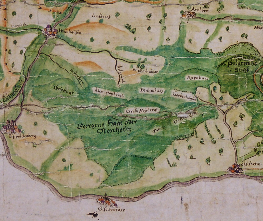
↑ Historical map of Gieselwerder and the Werderholz 1570
(excerpt from: Ortssippenbuch Gieselwerder on klauskunze.com) -
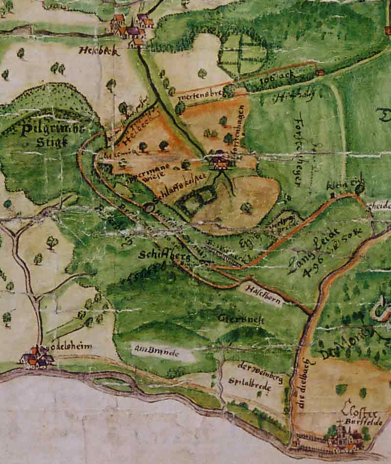
↑ Historical map of Oedelsheim and the surrounding area 1570
(excerpt from: Ortssippenbuch Oedelsheim on klauskunze.com) -
↑ Topographical map of hiking and leisure in the Solling-Vogler Nature Park
(see section Literature / Sources ) - ^ Jürgen Hövermann: Geographical land survey: The natural space units on sheet 99 Göttingen. Federal Institute for Regional Studies, Bad Godesberg 1963. → Online map (PDF; 4.1 MB)
- ^ Main State Archives Hanover, Cal. Br. 1 - 1324., 1559
literature
For example, the information in this article is based on
- Recreational map of the Habichtswald / Reinhardswald Nature Park (TF 50-HR; 1: 50,000; 2003),
publisher : Hessisch-Waldeckischer Gebirgs- und Heimatverein e. V. and Hessian Land Surveying Office, ISBN 3-89446-319-8 - Cycling and hiking map Reinhardswald, Weserlauf and Bramwald (1: 33.333),
publisher: Geo-Verlag (Kaufungen) - Topographic map of hiking and leisure in the Solling-Vogler Nature Park (1: 50,000; 1975),
publisher: Lower Saxony State Administration Office - State Surveying - Kiffing : Gottfried Schlaf and Schlaf-Mehrlein, Christa (ed.), Chronik von Oedelsheim , Oberweser 2000, p. 36, ISBN 3-00-006114-2
Coordinates: 51 ° 36 ' N , 9 ° 36' E