Dane County
 Dane County Courthouse |
|
| administration | |
|---|---|
| US state : | Wisconsin |
| Administrative headquarters : | Madison |
| Foundation : | 1836 |
| Demographics | |
| Residents : | 488,073 (2010) |
| Population density : | 156.8 inhabitants / km 2 |
| geography | |
| Total area : | 3207 km² |
| Water surface : | 94 km² |
| map | |
| Website : www.countyofdane.com | |
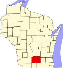
The Dane County is since 1836 existing County in the US state of Wisconsin . In 2010 , the county had 488,073 residents and a population density of 156.8 people per square kilometer.
The county seat is Madison . The largest cities in Dane County are Madison, Sun Prairie , Fitchburg , Middleton, and Stoughton .
Dane County is the center of the metropolitan area of Madison .
geography
Dane County is located in south-central Wisconsin and covers an area of 3,207 square kilometers, which is divided into 3,113 square kilometers of land and 94 square kilometers of water.
The largest lakes are Lake Mendota (39.8 square kilometers), Lake Monona (13.2 square kilometers), Lake Waubesa (8.4 square kilometers), and Lake Kegonsa (13.0 square kilometers) in and around Wisconsin's capital Madison . In this order, the lakes are traversed by the Yahara River , a tributary of the Rock River, which flows into the Mississippi in the neighboring state of Illinois .
In the extreme northwest, Dane County is bounded by the Wisconsin River , which also flows into the Mississippi on the approximately 130 km western border with Iowa .
The following neighboring counties border Dane County:
| Sauk County | Columbia County | Dodge County |
| Iowa County |

|
Jefferson County |
| Green County | Rock county |
history
| Population development | |||
|---|---|---|---|
| Census | Residents | ± in% | |
| 1900 | 69,435 | - | |
| 1910 | 77,435 | 11.5% | |
| 1920 | 89,432 | 15.5% | |
| 1930 | 112,737 | 26.1% | |
| 1940 | 130,660 | 15.9% | |
| 1950 | 169.357 | 29.6% | |
| 1960 | 222,095 | 31.1% | |
| 1970 | 290.272 | 30.7% | |
| 1980 | 323,545 | 11.5% | |
| 1990 | 367.085 | 13.5% | |
| 2000 | 426,526 | 16.2% | |
| 2010 | 488.073 | 14.4% | |
| 2012 estimate | 503.523 | 3.2% | |
| 1900–1990 2000 2010–2012 | |||
Dane County was founded in 1836 on former Indian land. It was named after Nathan Dane , a member of the Continental Congress from Massachusetts . This was to recognize its crucial role in legislation in the Northwest Territory , which later became the state of Wisconsin, among others.
population
According to the 2010 census , Dane County had 488,073 people in 199,767 households. The population density was 156.8 people per square kilometer. Statistically, 2.35 people lived in 199,767 households.
The racial the population was composed of 86.6 percent white, 5.4 percent African American, 0.5 percent Native American, 5.1 percent Asian and other ethnic groups; 2.4 percent were descended from two or more races. Hispanic or Latino of any race was 6.1 percent of the population.
21.3 percent of the population were under 18 years old, 67.7 percent were between 18 and 64 and 11.0 percent were 65 years or older. 50.4 percent of the population was female.
The median income for a household was 61,913 USD . The per capita income was $ 33,118. 12.0 percent of the population lived below the poverty line.
A small German-speaking minority speaks a dialect similar to Kölsch .
Localities in Dane County
Other Unincorporated Communities
1 - mostly in Rock County
2 - partly in Green County
3 - partly in Jefferson County
structure
In addition to the eight cities and 19 villages, Dane County is divided into 34 towns :
See also
Individual evidence
- ^ Dane County in the United States Geological Survey's Geographic Names Information System.Retrieved February 22, 2011
- ↑ a b c U.S. Census Bureau, State & County QuickFacts - Dane County, WI ( Memento of the original from July 9, 2011 on WebCite ) Info: The archive link was automatically inserted and not yet checked. Please check the original and archive link according to the instructions and then remove this notice. Retrieved November 14, 2013
- ^ A b National Association of Counties.Retrieved November 14, 2013
- ^ Extract from Census.gov.Retrieved February 28, 2011
- ^ Center for the Study of Upper Midwestern Countries: German Dialects in Wisconsin. In: American Languages: Our nation's many voices online. October 27, 2010, accessed November 27, 2013 .
- ↑ Missouri Census Data Center - Wisconsin ( page no longer available , search in web archives ) Info: The link was automatically marked as defective. Please check the link according to the instructions and then remove this notice. Retrieved November 14, 2013
Web links
Coordinates: 43 ° 4 ′ N , 89 ° 25 ′ W


