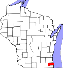
Racine County
![Racine County Courthouse, listed on the NRHP since 1980 [1]](https://upload.wikimedia.org/wikipedia/commons/thumb/9/95/RacineCountyCourtHouse.jpg/298px-RacineCountyCourtHouse.jpg) Racine County Courthouse, listed on the NRHP since 1980 |
|
| administration | |
|---|---|
| US state : | Wisconsin |
| Administrative headquarters : | Racine |
| Address of the administrative headquarters: |
County Courthouse 730 Wisconsin Avenue Racine, WI 53403-1238 |
| Foundation : | 1836 |
| Made up from: | Original County |
| Area code : | 001 262 |
| Demographics | |
| Residents : | 195,408 (2010) |
| Population density : | 226.4 inhabitants / km 2 |
| geography | |
| Total area : | 2051 km² |
| Water surface : | 1188 km² |
| map | |
| Website : www.racineco.com | |
The Racine County is a county in the US -amerikanischen State Wisconsin . In 2010 , the county had 195,408 residents and a population density of 226.4 people per square kilometer. By 2013 the population had decreased to 195,041. The county seat is Racine .
Racine County is part of the Milwaukee metropolitan area
geography
The county is located in southeastern Wisconsin, about 30 km from Illinois in the south and borders Lake Michigan in the east . It has an area of 2051 square kilometers, of which 1188 square kilometers are water.
In the east of the county is the confluence of the Root River in Lake Michigan. In the west, the county is traversed from north to south by the Fox River , which belongs to the Mississippi River basin over the Illinois River .
The following neighboring counties border Racine County:
| Waukesha County | Milwaukee County | |
| Walworth County |

|
|
| Kenosha County |
history
Racine County was formed in 1836 as the original county from parts of the Wisconsin Territory. It was named, like the district capital, after the former French name for the Root River.
population
| Population development | |||
|---|---|---|---|
| Census | Residents | ± in% | |
| 1850 | 14,973 | - | |
| 1860 | 21,360 | 42.7% | |
| 1870 | 26,740 | 25.2% | |
| 1880 | 30,922 | 15.6% | |
| 1890 | 36,268 | 17.3% | |
| 1900 | 45,644 | 25.9% | |
| 1910 | 57,424 | 25.8% | |
| 1920 | 78,961 | 37.5% | |
| 1930 | 90.217 | 14.3% | |
| 1940 | 94,047 | 4.2% | |
| 1950 | 109,585 | 16.5% | |
| 1960 | 141,781 | 29.4% | |
| 1970 | 170,838 | 20.5% | |
| 1980 | 173.132 | 1.3% | |
| 1990 | 175.034 | 1.1% | |
| 2000 | 188,831 | 7.9% | |
| 2010 | 195,408 | 3.5% | |
| 2013 estimate | 195.041 | -0.2% | |
| 1900–1990 2000 2010–2013 | |||
According to the 2010 census , Racine County had 195,408 people in 75,775 households. The population density was 226.4 inhabitants per square kilometer. Statistically, 2.5 people lived in each of the 75,775 households.
The racial the population was composed of 84.4 percent white, 11.6 percent African American, 0.6 percent Native American, 1.2 percent Asian, 0.1 percent Polynesian and other ethnic groups; 2.2 percent were descended from two or more races. Hispanic or Latino of any race was 12.3 percent of the population.
24.1 percent of the population were under 18 years old, 61.6 percent were between 18 and 64 and 14.3 percent were 65 years or older. 50.4 percent of the population were female.
The median income for a household was 54,900 USD . The per capita income was $ 27,292. 12.6 percent of the population lived below the poverty line.
Localities in Racine County
Census-designated places (CDP)
Other Unincorporated Communities
1 - partially in Walworth County
structure
In addition to the two cities and nine villages, Racine County is divided into six towns :
| Town | Population (2010) |
FIPS |
|---|---|---|
| Town of Burlington | 6502 | 55-11225 |
| Town of Dover | 4051 | 55-20625 |
| Town of Norway | 7948 | 55-58600 |
| Town of Raymond | 3870 | 55-66375 |
| Town of Waterford | 6344 | 55-83850 |
| Town of Yorkville | 3071 | 55-89575 |
See also
Individual evidence
- ↑ Extract from the National Register of Historic Places - No. 80000179.Retrieved August 15, 2014
- ^ Racine County in the United States Geological Survey's Geographic Names Information System.Retrieved February 22, 2011
- ↑ a b c U.S. Census Bureau, State & County QuickFacts - Racine County, WI Retrieved August 15, 2014
- ↑ a b National Association of Counties.Retrieved August 15, 2014
- ^ Extract from Census.gov.Retrieved February 28, 2011
- ↑ Missouri Census Data Center - Wisconsin ( Memento of the original from January 18, 2016 in the Internet Archive ) Info: The archive link was inserted automatically and has not yet been checked. Please check the original and archive link according to the instructions and then remove this notice. Retrieved August 15, 2014
Web links
- Official website
- Racine County Convention and Visitors Bureau
- city-data.com - Racine County, Wisconsin
Coordinates: 42 ° 47 ′ N , 87 ° 46 ′ W

