Pierce County, Wisconsin
![Pierce County Courthouse, listed on the NRHP since 1982 [1]](https://upload.wikimedia.org/wikipedia/commons/thumb/4/45/PierceCountyCourthouseEllsworthWisconsin.jpg/298px-PierceCountyCourthouseEllsworthWisconsin.jpg) Pierce County Courthouse, listed on the NRHP since 1982 |
|
| administration | |
|---|---|
| US state : | Wisconsin |
| Administrative headquarters : | Ellsworth |
| Address of the administrative headquarters: |
County Courthouse 414 West Main Street Ellsworth, WI 54011-0119 |
| Foundation : | 1853 |
| Made up from: | St. Croix County |
| Area code : | 001 |
| Demographics | |
| Residents : | 41,019 (2010) |
| Population density : | 27.5 inhabitants / km 2 |
| geography | |
| Total area : | 1532 km² |
| Water surface : | 39 km² |
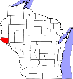
| map | |
| Website : www.co.pierce.wi.us | |
The Pierce County is a county in western US -amerikanischen state of Wisconsin . In 2010 , the county had 41,019 residents and a population density of 27.5 people per square kilometer. The county seat is Ellsworth , named after Elmer E. Ellsworth , a colonel during the American Civil War .
Pierce County is part of the Minneapolis - Saint Paul metropolitan area .
geography
The county is located in the far west of Wisconsin, bordering Minnesota , separated by the St. Croix River and the Mississippi , which are the natural border. It has an area of 1532 square kilometers, of which 39 square kilometers are water. The following neighboring counties border Pierce County:
| St. Croix County | Dunn County | |
|
Washington County, Minnesota |

|
|
|
Dakota County, Minnesota |
Goodhue County, Minnesota |
Pepin County |
history
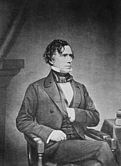
Pierce County was formed in 1853 from parts of St. Croix County. It was named after Franklin Pierce , the 14th President of the USA.
Demographic data
| Population development | |||
|---|---|---|---|
| Census | Residents | ± in% | |
| 1860 | 4672 | - | |
| 1870 | 9958 | 113.1% | |
| 1880 | 17,744 | 78.2% | |
| 1890 | 20,385 | 14.9% | |
| 1900 | 23,943 | 17.5% | |
| 1910 | 22,079 | -7.8% | |
| 1920 | 21,663 | -1.9% | |
| 1930 | 21,043 | -2.9% | |
| 1940 | 21,471 | 2% | |
| 1950 | 21,448 | -0.1% | |
| 1960 | 22,503 | 4.9% | |
| 1970 | 26,652 | 18.4% | |
| 1980 | 31,149 | 16.9% | |
| 1990 | 32,765 | 5.2% | |
| 2000 | 36,804 | 12.3% | |
| 2010 | 41,019 | 11.5% | |
| before 1900 1900–1990 2000 2010 | |||
According to the 2010 census , Pierce County had 41,019 people in 14,817 households. The population density was 27.5 inhabitants per square kilometer. Statistically, 2.54 people lived in the 14,817 households.
The racial the population was composed of 96.6 percent white, 0.6 percent African American, 0.4 percent Native American, 0.7 percent Asian and other ethnic groups; 1.3 percent were descended from two or more races. Regardless of ethnicity, 1.5 percent of the population was Hispanic or Latino of any race.
22.3 percent of the population were under 18 years old, 67.3 percent were between 18 and 64 and 10.4 percent were 65 years or older. 50.2 percent of the population was female.
The median income for a household was 60,181 USD . The per capita income was $ 26,313. 10.3 percent of the population lived below the poverty line.
Pierce County localities
Census-designated places (CDP)
Other Unincorporated Communities
1 - partly in St. Croix County
2 - partly in Dunn and in St. Croix County
3 - partly in Pepin County
structure
Pierce County is divided into 17 towns in addition to the eight independent parishes (cities, villages) :
|
|
|
The independent parishes of Ellsworth , Maiden Rock and River Falls are not identical to the towns of the same name.
See also
Individual evidence
- ↑ Extract from the National Register of Historic Places - No. 82000696. Retrieved April 11, 2011
- ↑ Pierce County in the United States Geological Survey's Geographic Names Information System.Retrieved February 22, 2011
- ↑ a b c U.S. Census Bureau, State & County QuickFacts - Pierce County, WI ( Memento of the original from July 16, 2011 on WebCite ) Info: The archive link was automatically inserted and has not yet been checked. Please check the original and archive link according to the instructions and then remove this notice. Retrieved March 25, 2013
- ↑ a b National Association of Counties.Retrieved March 25, 2013
- ^ University of Virginia Library - Historical Census Browser. Retrieved March 14, 2014
- ^ Extract from Census.gov.Retrieved February 28, 2011
- ↑ Missouri Census Data Center - Wisconsin ( page no longer available , search in web archives ) Info: The link was automatically marked as defective. Please check the link according to the instructions and then remove this notice. Retrieved March 25, 2013
Web links
Coordinates: 44 ° 43 ′ N , 92 ° 25 ′ W

