Burnett County
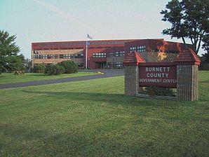
 The Burnett County Government Center in the Town of Meenon |
|
| administration | |
|---|---|
| US state : | Wisconsin |
| Administrative headquarters : | Town of Meenon |
| Address of the administrative headquarters: |
Burnett County Government Center 7410 County Road K Siren, WI 54872-0000 |
| Foundation : | 1856 |
| Made up from: | Polk County |
| Area code : | 001 715 |
| Demographics | |
| Residents : | 15,457 (2010) |
| Population density : | 7.3 inhabitants / km 2 |
| geography | |
| Total area : | 2280 km² |
| Water surface : | 152 km² |
| map | |
| Website : www.burnettcounty.com | |
The Burnett County is a county in the US -amerikanischen State Wisconsin . In 2010 , the county had 15,457 residents and a population density of 7.3 people per square kilometer. The county seat is north of Siren in the Town of Meenon .
geography
The county is located in northwest Wisconsin, on the left bank of the St. Croix River , which forms the border with Minnesota . It has an area of 2280 square kilometers, of which 152 square kilometers are water. The following neighboring counties border Burnett County:
| Douglas County | ||
| Pine County, Minnesota |

|
Washburn County |
| Chisago County, Minnesota | Polk County | Barron County |
history
Burnett County was formed in 1856 from parts of Polk County. It was named after Thomas P. Burnett (1800-1846), a member of the House of Representatives for the Wisconsin Territory .
population
| Population development | |||
|---|---|---|---|
| Census | Residents | ± in% | |
| 1900 | 7478 | - | |
| 1910 | 9026 | 20.7% | |
| 1920 | 10,735 | 18.9% | |
| 1930 | 10,233 | -4.7% | |
| 1940 | 11,382 | 11.2% | |
| 1950 | 10,236 | -10.1% | |
| 1960 | 9214 | -10% | |
| 1970 | 9276 | 0.7% | |
| 1980 | 12,340 | 33% | |
| 1990 | 13,084 | 6% | |
| 2000 | 15,674 | 19.8% | |
| 2010 | 15,457 | -1.4% | |
| 2012 estimate | 15,382 | -0.5% | |
| 1900–1990 2000 2010–2012 | |||
After the census in 2010 15,457 people lived in Burnett County in 7372 households. The population density was 7.3 people per square kilometer. Statistically speaking, 2.09 people lived in the 7,372 households.
The racial the population was composed of 91.8 percent white, 0.6 percent African American, 4.8 percent Native American, 0.4 percent Asian and other ethnic groups; 2.5 percent were descended from two or more races. Regardless of ethnicity, 1.5 percent of the population was Hispanic or Latino of any race.
19.1 percent of the population were under 18 years old, 53.2 percent were between 18 and 64 and 27.7 percent were 65 years or older. 49.3 percent of the population was female.
The median income for a household was 40,686 USD . The per capita income was $ 22,872. 17.8 percent of the population lived below the poverty line.
Burnett County localities
Other Unincorporated Communities
structure
In addition to the three villages, Burnett County is divided into 21 towns :
|
|
|
See also
Individual evidence
- ↑ Burnett County in the Geographic Names Information System of the United States Geological Survey Accessed 22 February 2011
- ↑ a b c U.S. Census Bureau, State & County QuickFacts - Burnett County, WI. Retrieved September 2, 2013
- ↑ a b National Association of Counties.Retrieved September 2, 2013
- ^ Extract from Census.gov.Retrieved February 28, 2011
- ↑ Missouri Census Data Center - Wisconsin ( page no longer available , search in web archives ) Info: The link was automatically marked as defective. Please check the link according to the instructions and then remove this notice. Retrieved September 2, 2013
Web links
Coordinates: 45 ° 52 ′ N , 92 ° 22 ′ W

