Pine County
 Pine County Courthouse |
|
| administration | |
|---|---|
| US state : | Minnesota |
| Administrative headquarters : | Pine City |
| Address of the administrative headquarters: |
County Courthouse 315 Main Street South Pine City, MN 55063-1620 |
| Foundation : | March 1, 1856 |
| Made up from: |
Chisago County Ramsey County |
| Area code : | 001 320 |
| Demographics | |
| Residents : | 29,750 (2010) |
| Population density : | 8.1 inhabitants / km 2 |
| geography | |
| Total area : | 3716 km² |
| Water surface : | 61 km² |
| map | |
| Website : www.co.pine.mn.us | |
The Pine County is a county in the US -amerikanischen State Minnesota . In 2010 , the county had 29,750 people and a population density of 8.1 people per square kilometer. The county seat is Pine City .
Parts of the Fond du Lac Reservation , an Indian reservation of the Anishinabe , are in Pine County.
geography
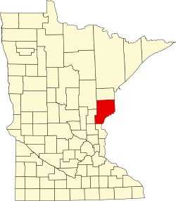
The county is located in east Minnesota and borders Wisconsin to the east , from which it is separated to the southeast by the St. Croix River . In a northeasterly direction is the southern tip of Lake Superior , about 30 km away , the westernmost of the Great Lakes . Pine County covers an area of 3716 square kilometers, of which 61 square kilometers are water. It borders on the following neighboring counties:
| Aitkin County | Carlton County |
Douglas County, Wisconsin |
| Kanabec County |

|
Burnett County, Wisconsin |
| Isanti County | Chisago County |
history
Pine County was formed on March 1, 1856 from parts of Chisago County and Ramsey County. It was named after the pine trees that grow here .
One location in Pine County has the status of a National Historic Landmark , the St. Croix Recreational Demonstration Area . 23 buildings and sites in the county are registered in the National Register of Historic Places (as of January 31, 2018).
Demographic data
| Population development | |||
|---|---|---|---|
| Census | Residents | ± in% | |
| 1860 | 92 | - | |
| 1870 | 648 | 604.3% | |
| 1880 | 1365 | 110.6% | |
| 1890 | 4052 | 196.8% | |
| 1900 | 11,546 | 184.9% | |
| 1910 | 15,878 | 37.5% | |
| 1920 | 21,117 | 33% | |
| 1930 | 20,264 | -4% | |
| 1940 | 21,478 | 6% | |
| 1950 | 18,223 | -15.2% | |
| 1960 | 17.004 | -6.7% | |
| 1970 | 16,821 | -1.1% | |
| 1980 | 19,871 | 18.1% | |
| 1990 | 21,264 | 7% | |
| 2000 | 26,530 | 24.8% | |
| 2010 | 29,750 | 12.1% | |
| Before 1900 1900–1990 2000 2010 | |||

According to the 2010 census , Pine County had 29,750 people in 11,862 households. The population density was 8.1 people per square kilometer. Statistically, 2.35 people lived in the 11,862 households.
The racial the population was composed of 92.3 percent white, 2.2 percent African American, 3.2 percent Native American, 0.5 percent Asian and other ethnic groups; 1.8 percent were descended from two or more races. Regardless of ethnicity, 2.5 percent of the population was Hispanic or Latino of any race.
21.5 percent of the population were under 18 years old, 61.8 percent were between 18 and 64 and 16.7 percent were 65 years or older. 46.5 percent of the population was female.
The median income for a household was 44,463 USD . The per capita income was $ 21,769. 15.0 percent of the population lived below the poverty line.
Pine County localities
structure
Pine County is divided into 33 townships in addition to the 14 cities :
See also
Individual evidence
- ↑ GNIS-ID: 659503. Retrieved on February 22, 2011 (English).
- ↑ a b c U.S. Census Bureau, State & County QuickFacts - Pine County, MN ( July 16, 2011 memento on WebCite ) Retrieved June 1, 2013
- ^ A b National Association of Counties.Retrieved June 1, 2013
- ↑ Listing of National Historic Landmarks by State: Minnesota . National Park Service , accessed January 31, 2018.
- ↑ Search mask database in the National Register Information System. National Park Service , accessed January 31, 2018.
- ^ US Census Bureau - Census of Population and Housing.Retrieved March 15, 2011
- ↑ Extract from Census.gov.Retrieved February 17, 2011
- ^ Census 2010 - Minnesota , Retrieved May 5, 2020
Web links
Coordinates: 46 ° 8 ′ N , 92 ° 44 ′ W

