Rice County, Minnesota
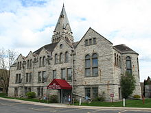
![Rice County Courthouse, listed on NRHP No. 82003016 [1]](https://upload.wikimedia.org/wikipedia/commons/thumb/9/93/RiceCountyCourthouse.JPG/298px-RiceCountyCourthouse.JPG) Rice County Courthouse, listed on NRHP No. 82003016 |
|
| administration | |
|---|---|
| US state : | Minnesota |
| Administrative headquarters : | Faribault |
| Address of the administrative headquarters: |
County Government Services Building 320 NW Third Street Faribault, MN 55021-5195 |
| Foundation : | March 5, 1853 |
| Made up from: |
Dakota County Wabasha County |
| Area code : | 001 507 |
| Demographics | |
| Residents : | 64,142 (2010) |
| Population density : | 49.8 inhabitants / km 2 |
| geography | |
| Total area : | 1337 km² |
| Water surface : | 48 km² |
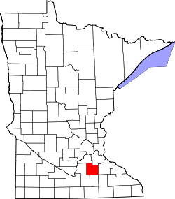
| map | |
| Website : www.co.rice.mn.us | |
The Rice County is a county of the middle southeastern US -amerikanischen state of Minnesota . In 2010 , the county had 64,142 residents and a population density of 49.8 people per square kilometer. The county seat is Faribault .
Rice County is part of the CSA (Combined Statistical Area) Minneapolis-St. Paul-St. Cloud , the expanded Minneapolis-Saint Paul metropolitan area .
geography
The county is located in southeastern Minnesota. It has an area of 1337 square kilometers, of which 48 square kilometers are water. In Rice County, the Straight River flows into the Cannon River , a right tributary of the Mississippi .
The following neighboring counties border Rice County:
| Scott County | Dakota County | |
| Le Sueur County |

|
Goodhue County |
| Waseca County | Steele County | Dodge County |
history
Rice County was formed on March 5, 1853 from parts of Dakota County and Wabasha County. It was named after Henry Mower Rice (1816-1894), a US politician and from 1858 to 1863 US Senator from Minnesota.
Two locations in Rice County have National Historic Landmark status , the OE Rolvaag House and the Thorstein Veblen Farmstead . 74 buildings and sites in the county are registered in the National Register of Historic Places (as of January 31, 2018).
Demographic data
| Population development | |||
|---|---|---|---|
| Census | Residents | ± in% | |
| 1860 | 7543 | - | |
| 1870 | 16,083 | 113.2% | |
| 1880 | 22,481 | 39.8% | |
| 1890 | 23,968 | 6.6% | |
| 1900 | 26,080 | 8.8% | |
| 1910 | 25,911 | -0.6% | |
| 1920 | 28,307 | 9.2% | |
| 1930 | 29,974 | 5.9% | |
| 1940 | 32,160 | 7.3% | |
| 1950 | 36,235 | 12.7% | |
| 1960 | 38,988 | 7.6% | |
| 1970 | 41,582 | 6.7% | |
| 1980 | 46,087 | 10.8% | |
| 1990 | 49.183 | 6.7% | |
| 2000 | 56,665 | 15.2% | |
| 2010 | 64,142 | 13.2% | |
| Before 1900 1900–1990 2000 2010 | |||
As of the 2010 census , Rice County had 64,142 people in 22,117 households. The population density was 49.8 inhabitants per square kilometer. Statistically, 2.51 people lived in each of the 22,117 households.
The racial the population was composed of 92.3 percent white, 3.4 percent African American, 0.6 percent Native American, 2.1 percent Asian, 0.1 percent Polynesian and other ethnic groups; 1.5 percent were descended from two or more races. Regardless of ethnicity, 8.0 percent of the population was Hispanic or Latino of any race.
23.1 percent of the population were under 18 years old, 64.2 percent were between 18 and 64 and 12.7 percent were 65 years or older. 48.9 percent of the population was female.
The median income for a household was 59,533 USD . The per capita income was $ 24,783. 10.8 percent of the population lived below the poverty line.
Towns in Rice County
Other Unincorporated Communities
1 - partly in Goodhue County
2 - partly in Dakota County
3 - partly in Steele County
structure
Besides the seven cities, Rice County is divided into 14 townships :
|
|
See also
Individual evidence
- ^ Extract from the National Register of Historic Places.Retrieved March 13, 2011
- ↑ GNIS-ID: 659511. Retrieved on February 22, 2011 (English).
- ↑ a b c U.S. Census Bureau, State & County QuickFacts - Rice County, MN. Retrieved March 20, 2013
- ↑ a b National Association of Counties.Retrieved March 20, 2013
- ↑ Listing of National Historic Landmarks by State: Minnesota . National Park Service , accessed January 31, 2018.
- ↑ Search mask database in the National Register Information System. National Park Service , accessed January 31, 2018.
- ^ US Census Bureau _ Census of Population and Housing.Retrieved February 17, 2011
- ↑ Extract from Census.gov.Retrieved February 17, 2011
- ^ Census 2010 - Minnesota , Retrieved May 5, 2020
Web links
Coordinates: 44 ° 22 ′ N , 93 ° 18 ′ W


