
Sibley County
![Sibley County Courthouse, listed on the NRHP since 1988 [1]](https://de.wikipedia.org/wiki/Datei:2013-0415-SibleyCtyCourthouse.jpg) Sibley County Courthouse, listed on the NRHP since 1988 |
|
| administration | |
|---|---|
| US state : | Minnesota |
| Administrative headquarters : | Gaylord |
| Address of the administrative headquarters: |
County Courthouse P.O. Box 171 Gaylord, MN 55334-0171 |
| Foundation : | March 5, 1853 |
| Made up from: | Dakota County |
| Area code : | 001 507 |
| Demographics | |
| Residents : | 15,226 (2010) |
| Population density : | 10 inhabitants / km 2 |
| geography | |
| Total area : | 1555 km² |
| Water surface : | 30 km² |
| map | |
 |
|
| Website : www.co.sibley.mn.us | |
The Sibley County is a county in the US -amerikanischen State Minnesota . In 2010 , the county had 15,226 residents and a population density of 10 people per square kilometer. The county seat is Gaylord .
geography
The county is located in south central Minnesota on the west bank of the Minnesota River . It has an area of 1555 square kilometers, of which 30 square kilometers are water. The following neighboring counties border Sibley County:
| McLeod County | Carver County | |
|
Renville County |
.svg)
|
Scott County |
| Nicollet County | Le Sueur County |
history

Sibley County was formed on March 5, 1853 from parts of Dakota County. It was named after Henry Hastings Sibley (1811-1891), the first governor of Minnesota (1858-1860).
Historical objects

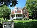
The former Sibley County Courthouse in Henderson, listed on the NRHP since 1982
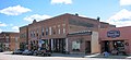
Henderson Commercial Historic District , listed on the NRHP
August F. Poehler House , listed in the NRHP


Other objects:
| Population development | |||
|---|---|---|---|
| Census | Residents | ± in% | |
| 1860 | 3609 | - | |
| 1870 | 6725 | 86.3% | |
| 1880 | 10,637 | 58.2% | |
| 1890 | 15.199 | 42.9% | |
| 1900 | 16,862 | 10.9% | |
| 1910 | 15,540 | -7.8% | |
| 1920 | 15,635 | 0.6% | |
| 1930 | 15,865 | 1.5% | |
| 1940 | 16,625 | 4.8% | |
| 1950 | 15,816 | -4.9% | |
| 1960 | 16,228 | 2.6% | |
| 1970 | 15,845 | -2.4% | |
| 1980 | 15,448 | -2.5% | |
| 1990 | 14,366 | -7% | |
| 2000 | 15,356 | 6.9% | |
| 2010 | 15,226 | -0.8% | |
| Before 1900 1900–1990 2000 2010 | |||
Demographic data
According to the 2010 census , Sibley County had 15,226 people in 6,103 households. The population density was 10 people per square kilometer. In the 6103 households there were statistically 2.42 people each.
The racial the population was composed of 97.5 percent white, 0.5 percent African American, 0.3 percent Native American, 0.6 percent Asian and other ethnic groups; 1.2 percent were descended from two or more races. Hispanic or Latino of any race was 7.6 percent of the population.
25.1 percent of the population were under 18 years old, 58.6 percent were between 18 and 64 and 16.3 percent were 65 years or older. 49.9 percent of the population was female.
The median income for a household was 52,482 USD . The per capita income was $ 24,563. 12.1 percent of the population lived below the poverty line.
Localities in Sibley County
1 - partly in Le Sueur County
structure
In addition to the eight cities, Sibley County is divided into 17 townships :
|
|
Individual evidence
- ↑ Extract from the National Register of Historic Places - No. 88003071.Retrieved June 20, 2013
- ↑ GNIS-ID: 659516. Retrieved on February 22, 2011 (English).
- ↑ a b c U.S. Census Bureau, State & County QuickFacts - Sibley County, MN. Retrieved June 20, 2013
- ^ A b National Association of Counties.Retrieved June 20, 2013
- ↑ Extract from the National Register of Historic Places - No. 82003037. Retrieved August 11, 2011
- ^ US Census Bureau _ Census of Population and Housing.Retrieved August 11, 2011
- ↑ Extract from Census.gov.Retrieved August 11, 2011
- ^ Census 2010 - Minnesota , Retrieved May 5, 2020
Web links
List of counties in Minnesota
Aitkin |
Anoka |
Becker |
Beltrami |
Benton |
Big Stone |
Blue Earth |
Brown |
Carlton |
Carver |
Cass |
Chippewa |
Chisago |
Clay |
Clearwater |
Cook |
Cottonwood |
Crow Wing |
Dakota |
Dodge |
Douglas |
Faribault |
Fillmore |
Freeborn |
Goodhue |
Grant |
Hennepin |
Houston |
Hubbard |
Isanti |
Itasca |
Jackson |
Kanabec |
Kandiyohi |
Kittson |
Koochiching |
Lac qui Parle |
Lake |
Lake of the Woods |
Le Sueur |
Lincoln |
Lyon |
Reminders |
Marshall |
Martin |
McLeod |
Meeker |
Mille Lacs |
Morrison |
Mower |
Murray |
Nicollet |
Nobles |
Norman |
Olmsted |
Otter Tail |
Pennington |
Pine |
Pipestone |
Polk |
Pope |
Ramsey |
Red Lake |
Redwood |
Renville |
Rice |
Skirt |
Roseau |
Scott |
Sherburne |
Sibley |
St. Louis |
Stearns |
Steele |
Stevens |
Swift |
Todd |
Traverse |
Wabasha |
Wadena |
Waseca |
Washington |
Watonwan |
Wilkin |
Winona |
Wright |
Yellow Medicine
Coordinates: 45 ° 26 ' N , 93 ° 46' W