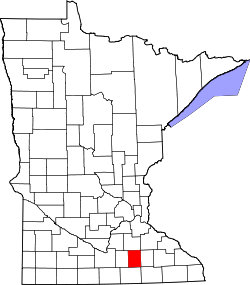
Steele County, Minnesota
![Steele County Courthouse, listed on NRHP No. 78001565 [1]](https://upload.wikimedia.org/wikipedia/commons/thumb/4/44/SteeleCountyCourthouse2006OwatonnaMN.JPG/298px-SteeleCountyCourthouse2006OwatonnaMN.JPG) Steele County Courthouse, listed on NRHP No. 78001565 |
|
| administration | |
|---|---|
| US state : | Minnesota |
| Administrative headquarters : | Owatonna |
| Address of the administrative headquarters: |
County Courthouse 630 Florence Avenue Owatonna, MN 55060-4704 |
| Foundation : | February 20, 1855 |
| Made up from: |
Blue Earth County Le Sueur County Rice County |
| Area code : | 001 507 |
| Demographics | |
| Residents : | 36,576 (2010) |
| Population density : | 32.9 inhabitants / km 2 |
| geography | |
| Total area : | 1119 km² |
| Water surface : | 7 km² |
| map | |
| Website : www.co.steele.mn.us | |
The Steele County is a county in the US -amerikanischen State Minnesota . In 2010 , the county had 36,576 residents and a population density of 32.9 people per square kilometer. The county seat is Owatonna .
geography
The county is located in southeast Minnesota and is traversed from south to north by the Straight River , a tributary of the Cannon River, which flows into the Mississippi . The county is located approximately 50 km south of Iowa and covers an area of 1,119 square kilometers, of which seven square kilometers are water. The following neighboring counties border Steele County:
| Rice County | ||
| Waseca County |

|
Dodge County |
| Freeborn County | Mower County |
history
Steele County was formed on February 20, 1855 from parts of Blue Earth County, Le Sueur County and Rice County. It was named after Franklin Steele (1813-1880), one of the first white settlers in Minnesota.
One location in Steele County has the status of a National Historic Landmark , the National Farmer's Bank of Owatonna . Twelve buildings and sites in the county are listed in the National Register of Historic Places (as of January 31, 2018).
Demographic data
| Population development | |||
|---|---|---|---|
| Census | Residents | ± in% | |
| 1860 | 2803 | - | |
| 1870 | 8271 | 195.1% | |
| 1880 | 12,460 | 50.6% | |
| 1890 | 13,232 | 6.2% | |
| 1900 | 16,524 | 24.9% | |
| 1910 | 16,146 | -2.3% | |
| 1920 | 18,061 | 11.9% | |
| 1930 | 18,475 | 2.3% | |
| 1940 | 19,749 | 6.9% | |
| 1950 | 21,155 | 7.1% | |
| 1960 | 25,029 | 18.3% | |
| 1970 | 26,931 | 7.6% | |
| 1980 | 30,328 | 12.6% | |
| 1990 | 30,729 | 1.3% | |
| 2000 | 33,680 | 9.6% | |
| 2010 | 36,576 | 8.6% | |
| Before 1900 1900–1990 2000 2010 | |||
As of the 2010 census , Steele County had 36,576 people in 14,053 households. The population density was 32.9 inhabitants per square kilometer. Statistically, 2.55 people lived in the 14,053 households.
The racial the population was composed of 94.8 percent white, 2.8 percent African American, 0.3 percent Native American, 0.9 percent Asian and other ethnic groups; 1.2 percent were descended from two or more races. Regardless of ethnicity, 6.5 percent of the population was Hispanic or Latino of any race.
26.1 percent of the population were under 18 years old, 59.3 percent were between 18 and 64 and 14.6 percent were 65 years or older. 50.5 percent of the population was female.
The median income for a household was 57,290 USD . The per capita income was $ 26,114. 8.8 percent of the population lived below the poverty line.
Steele County localities
1 - partly in Dodge County
2 - partly in Rice County
structure
Steele County is divided into 13 townships in addition to the four cities :
| Township | Population (2010) |
FIPS |
|---|---|---|
| Aurora Township | 574 | 27-02890 |
| Berlin Township | 519 | 27-05374 |
| Blooming Prairie Township | 430 | 27-06598 |
| Clinton Falls Township | 351 | 27-12052 |
| Deerfield Township | 517 | 27-15256 |
| Havana Township | 570 | 27-27638 |
| Lemond Township | 501 | 27-36386 |
| Medford Township | 813 | 27-41444 |
| Meriden Township | 621 | 27-41750 |
| Merton Township | 348 | 27-41840 |
| Owatonna Township | 609 | 27-49318 |
| Somerset Township | 732 | 27-61150 |
| Summit Township | 466 | 27-63364 |
See also
Individual evidence
- ^ Extract from the National Register of Historic Places . Retrieved March 13, 2011
- ↑ GNIS-ID: 659518. Retrieved on February 22, 2011 (English).
- ↑ a b c U.S. Census Bureau, State & County QuickFacts - Steele County, MN. Retrieved June 23, 2013
- ↑ a b National Association of Counties.Retrieved June 23, 2013
- ↑ Listing of National Historic Landmarks by State: Minnesota . National Park Service , accessed January 31, 2018.
- ↑ Search mask database in the National Register Information System. National Park Service , accessed January 31, 2018.
- ^ US Census Bureau - Census of Population and Housing.Retrieved March 15, 2011
- ^ Extract from Census.gov.Retrieved February 18, 2011
- ^ Census 2010 - Minnesota , Retrieved May 5, 2020
Web links
Coordinates: 44 ° 1 ′ N , 93 ° 13 ′ W
