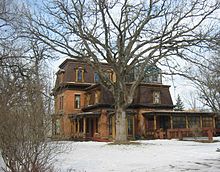
Dakota County, Minnesota
 The Dakota County Government Building in Hastings |
|
| administration | |
|---|---|
| US state : | Minnesota |
| Administrative headquarters : | Hastings |
| Address of the administrative headquarters: |
County Courthouse 1590 West Highway 55 Hastings, MN 55033-2372 |
| Foundation : | October 27, 1849 |
| Made up from: | free territory |
| Area code : | 001 651 |
| Demographics | |
| Residents : | 398,552 (2010) |
| Population density : | 270 inhabitants / km 2 |
| geography | |
| Total area : | 1519 km² |
| Water surface : | 43 km² |
| map | |
| Website : www.co.dakota.mn.us | |

The Dakota County is a county in the US -amerikanischen State Minnesota . In 2010 , the county had 398,552 people and a population density of 270 people per square kilometer. The county seat is Hastings , which was named after Governor Henry Hastings Sibley .
Dakota County forms the southeastern part of the Minneapolis-Saint Paul metropolitan area .
geography
The county is located in southeast Minnesota, bordering Wisconsin to the northeast, the border being formed by the Mississippi . The northern boundary of Dakota County is formed by the Minnesota River . It has an area of 1519 square kilometers, of which 43 square kilometers are water. The following neighboring counties border Dakota County:
| Hennepin County | Ramsey County | Washington County |
| Scott County |

|
Pierce County, Wisconsin |
| Rice County | Goodhue County |
history
The Dakota County was formed on October 27, 1849 from designated as free, but actually populated by Indians , territory. The county was named after the Dakota who originally settled here .
One place in Dakota County has the status of a National Historic Landmark , Fort Snelling . 35 buildings and sites in the county are registered in the National Register of Historic Places (as of January 28, 2018).
Demographic data
| Population development | |||
|---|---|---|---|
| Census | Residents | ± in% | |
| 1850 | 584 | - | |
| 1860 | 9093 | 1,457% | |
| 1870 | 16,312 | 79.4% | |
| 1880 | 17,391 | 6.6% | |
| 1890 | 20,240 | 16.4% | |
| 1900 | 21,733 | 7.4% | |
| 1910 | 25.171 | 15.8% | |
| 1920 | 28,967 | 15.1% | |
| 1930 | 34,592 | 19.4% | |
| 1940 | 39,660 | 14.7% | |
| 1950 | 49.019 | 23.6% | |
| 1960 | 78,303 | 59.7% | |
| 1970 | 139,808 | 78.5% | |
| 1980 | 194.279 | 39% | |
| 1990 | 275.227 | 41.7% | |
| 2000 | 355.904 | 29.3% | |
| 2010 | 398,552 | 12% | |
| Before 1900 1900–1990 2000 2010 | |||


As of the 2010 census , Dakota County had 398,552 people in 151,719 households. The population density was 270 inhabitants per square kilometer. Statistically, 2.6 people lived in each of the 151,719 households.
The racial the population was composed of 87.4 percent white, 4.9 percent African American, 0.5 percent Native American, 4.6 percent Asian, 0.1 percent Asian Polynesians and from other ethnic groups; 2.5 percent were descended from two or more races. Hispanic or Latino of any race was 6.1 percent of the population.
25.9 percent of the population were under 18 years old, 63.7 percent were between 18 and 64 and 10.4 percent were 65 years or older. 50.9 percent of the population was female.
The median income for a household was 73,723 USD . The per capita income was $ 34,822. 6.0 percent of the population lived below the poverty line.
Dakota County localities
structure
Dakota County is divided into 13 townships in addition to the 21 cities :
|
|
See also
Individual evidence
- ^ Extract from the National Register of Historic Places.Retrieved March 13, 2011
- ↑ GNIS-ID: 659464. Retrieved on February 22, 2011 (English).
- ↑ a b c U.S. Census Bureau, State & County QuickFacts - Dakota County, MN ( July 9, 2011 memento on WebCite ) Retrieved February 6, 2013
- ^ A b National Association of Counties.Retrieved February 6, 2013
- ↑ Listing of National Historic Landmarks by State: Minnesota . National Park Service , accessed January 28, 2018.
- ↑ Search mask database in the National Register Information System. National Park Service , accessed January 28, 2018.
- ^ US Census Bureau _ Census of Population and Housing.Retrieved February 17, 2011
- ↑ Extract from Census.gov . Retrieved February 17, 2011
- ^ Census 2010 - Minnesota , Retrieved May 5, 2020
Web links
Coordinates: 44 ° 41 ′ N , 93 ° 4 ′ W
