Inver Grove Heights
| Inver Grove Heights | |
|---|---|
|
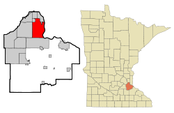
Location of the city in County and Minnesota
|
|
| Basic data | |
| State : | United States |
| State : | Minnesota |
| County : | Dakota County |
| Coordinates : | 44 ° 50 ′ N , 93 ° 3 ′ W |
| Time zone : | Central ( UTC − 6 / −5 ) |
| Residents : | 33,880 (as of 2010) |
| Population density : | 456.6 inhabitants per km 2 |
| Area : | 78.0 km 2 (approx. 30 mi 2 ) of which 74.2 km 2 (approx. 29 mi 2 ) are land |
| Height : | 268 m |
| Postcodes : | 55076, 55077 |
| Area code : | +1 651 |
| FIPS : | 27-31076 |
| GNIS ID : | 0645437 |
| Website : | www.ci.inver-grove-heights.mn.us |
| Mayor : | George Tourville |
Inver Grove Heights is a city in the US state of Minnesota . It is located in Dakota County and has a population of around 29,800.
geography
Inver Grove Heights is part of the Minneapolis-Saint Paul metropolitan area in the American Midwest . The city is about 14 kilometers southeast of St. Paul . The Mississippi River runs to the east of the city and serves as the city boundary.
According to the United States Census Bureau , the city is 78.0 square kilometers, of which 3.8 square kilometers are water.
history
After the Treaty of Traverse des Sioux, settlement began in the area in the 1850s. Mostly German and Irish immigrants settled there and formed a community. The Irish used the land around the Rich Valley for agriculture, while the Germans settled and cultivated the forest areas around the lakes in the northwest of today's city. In 1858 a township was established. By 1880 240 farms, four churches and four school districts had been built in the place.
After a village had been founded within the township in 1909, the town of Inver Grove Heights was formed on March 11, 1965 from the areas of the township and the village.
Population development
| 1970 | 1980 | 1990 | 2000 | 2009 |
|---|---|---|---|---|
| 12,148 | 17.171 | 22,477 | 29,751 | approx. 46,000 |
Demographic data
According to the 2000 census , Inver Grove Heights has 29,751 people in 11,257 households and 7,924 families. The racial the population is composed of 91.8 percent white population, 2.1 percent African American, 2.0 percent Asian American and other smaller or more groups. 4.2 percent of the population are Hispanics .
Children under the age of 18 live in 37.3% of the 11,257 households, married couples in 56.4%, female singles in 10.3% and 29.6% are not family households. 21.5% of all households consist exclusively of a single person and 4.7% are single people over 65 years of age. The average household size is 2.62 people, that of families 3.09.
In relation to the entire city, the population is composed of 27.3% residents under 18 years of age, 9.2% between 18 and 24 years of age, 33.9% between 25 and 44 years of age, 21.7% between 45 and 64 years of age 7.8% over 65 years. The median is 34 years. About 50.5% of the population is female.
The median income of a household is USD 59,090 and that of a family is USD 68,629. The per capita income is $ 25,493. About 4.2% of the population and 3.0% of families live below the poverty line.
traffic
The Interstate Highway 494 runs through the north of Inver Grove Heights. Other major highways are US Highway 52 and Minnesota State Route 55 . The Soo Line and Union Pacific Railroad also run through Inver Grove Heights.
The nearest airport is South St. Paul Municipal Airport in South St. Paul . The Minneapolis-Saint Paul International Airport is located about 13 kilometers northwest of the city.
