Rosemount, Minnesota
| Rosemount | |
|---|---|
 |
|
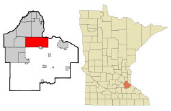
| Location in Minnesota | |
| Basic data | |
| Foundation : | 1856 |
| State : | United States |
| State : | Minnesota |
| County : | Dakota County |
| Coordinates : | 44 ° 44 ′ N , 93 ° 7 ′ W |
| Time zone : | Central ( UTC − 6 / −5 ) |
|
Inhabitants : - Metropolitan Area : |
21,874 (status: 2010) 3,279,833 (status: 2010) |
| Population density : | 254.2 inhabitants per km 2 |
| Area : | 91.19 km 2 (approx. 35 mi 2 ) of which 86.04 km 2 (approx. 33 mi 2 ) is land |
| Height : | 294 m |
| Postal code : | 55068 |
| Area code : | +1 651 |
| FIPS : | 27-55726 |
| GNIS ID : | 650291 |
| Website : | www.ci.rosemount.mn.us |
| Mayor : | Bill Droste |
Rosemount is a city (with the status " City ") in Dakota County in the US -amerikanischen State Minnesota . In 2010 , Rosemount had a population of 21,874.
Rosemount is part of the Minneapolis-Saint Paul metropolitan area .
geography
Rosemount is located in the southern suburbs of the cities of Minneapolis and Saint Paul on the right bank of the Mississippi at 44 ° 44'28 "north latitude and 93 ° 07'11" west longitude. The urban area extends over 91.19 km², which is spread over 86.04 km² of land and 5.15 km² of water.
In the south of the urban area, UMore Park is a site of the College of Food, Agricultural and Natural Resource Sciences at the University of Minnesota .
Neighboring locations to Rosemount are Eagan (on the northwest city limits), Inver Grove Heights (on the northern city limits), Hastings (14 miles east), Hampton (14 miles southeast), Farmington (12 miles south), Lakeville ( on the southwest city limits) and Apple Valley (on the western city limits).
Downtown Minneapolis is 24 miles north-northwest; the center of Saint Paul , the capital of Minnesota, is 17 miles north.
traffic
The four-lane US Highway 52 and the congruent Minnesota State Route 55 run through the west of Rosemount, one of the southern arterial roads from Saint Paul. Minnesota State Route 3 runs through the city center in a north-south direction . All other roads are subordinate partly unpaved roads as well as inner-city roads.
A Canadian Pacific Railway runs parallel to MN 3 . A line of the Union Pacific Railroad runs parallel to US 52 through the east of the city . A link within the Rosemount metropolitan area connects the two.
The nearest airport is Minneapolis-Saint Paul International Airport, 15 miles north .
Demographic data
| Population development | |||
|---|---|---|---|
| Census | Residents | ± in% | |
| 1880 | 116 | - | |
| 1890 | 198 | 70.7% | |
| 1900 | 182 | -8.1% | |
| 1910 | 238 | 30.8% | |
| 1920 | 310 | 30.3% | |
| 1930 | 294 | -5.2% | |
| 1940 | 364 | 23.8% | |
| 1950 | 567 | 55.8% | |
| 1960 | 1068 | 88.4% | |
| 1970 | 1337 | 25.2% | |
| 1980 | 5083 | 280.2% | |
| 1990 | 8622 | 69.6% | |
| 2000 | 14,619 | 69.6% | |
| 2010 | 21,874 | 49.6% | |
| 1880-2000 2010 | |||
As of the 2010 census , Rosemount had 21.74 people in 7,587 households. The population density was 254.2 people per square kilometer. In the 7587 households there were statistically 2.88 people each.
The racial the population was composed of 87.3 percent white, 3.0 percent African American, 0.4 percent Native American, 5.6 percent Asian and 1.1 percent from other ethnic groups; 2.6 percent were descended from two or more races. Hispanic or Latino of any race was 3.1 percent of the population.
30.7 percent of the population were under 18 years old, 61.6 percent were between 18 and 64 and 7.7 percent were 65 years or older. 56.6 percent of the population was female.
The average annual income for a household was 84,395 USD . The per capita income was $ 33,432. 4.9 percent of the population lived below the poverty line.
Individual evidence
- ↑ a b c American Fact Finder. Retrieved February 8, 2013
- ↑ umore Park Retrieved on February 8, 2013
- ↑ Distance information according to Google Maps. Accessed on February 8, 2013
- ↑ US Decennial Census. Retrieved February 4, 2013
