
Burnsville, Minnesota
| Burnsville | |
|---|---|
| Nickname : South of the River | |
 Grande Market Square in downtown Burnsville |
|
| Location in Minnesota | |
 |
|
| Basic data | |
| Foundation : | 1855 |
| State : | United States |
| State : | Minnesota |
| County : | Dakota County |
| Coordinates : | 44 ° 46 ′ N , 93 ° 17 ′ W |
| Time zone : | Central ( UTC − 6 / −5 ) |
| Residents : | 60,306 (as of 2010) |
| Population density : | 936.4 inhabitants per km 2 |
| Area : | 69.75 km 2 (approx. 27 mi 2 ) of which 64.4 km 2 (approx. 25 mi 2 ) is land |
| Height : | 297 m |
| Postcodes : | 55306, 55337 |
| Area code : | +1 952 |
| FIPS : | 27-08794 |
| GNIS ID : | 0640669 |
| Website : | www.ci.burnsville.mn.us |
| Mayor : | Elizabeth Kautz |
Burnsville [ bɜːnsˈvil ] is a city in Dakota County in the US state of Minnesota . It is located 15 miles south of downtown Minneapolis in the metropolitan area of the Twin Cities and has a population of around 60,000.
geography
Burnsville is a suburb of the major cities of Minneapolis and St. Paul , just south of the Minnesota River . According to the United States Census Bureau, the area of the city is 69.75 square kilometers, of which 5.23 square kilometers is water.
Neighboring communities
| Savage | Bloomington | Eagan |
| Savage |
.svg)
|
Rosemont |
| Prior Lake | Lakeville | Apple Valley |
history
The Dakota Indians were the first residents of the region. Around 1750 Chief Black Dog established a settlement north of the Minnesota River in the Mille Lacs Lake area. The area around the lakes around Burnsville was used for fishing and recreational activities, but also for burials.
According to the agreements between the United States government and the Indians, the Dakota left the area in 1851 and withdrew to reservations . One of the first European settlers, mainly from Ireland , was William Byrne, who moved from Ireland to Hamilton , Ontario in 1840 . In 1855 he settled about three kilometers west of what is now Interstate 35 . He donated land for a church, a school and a cemetery and served as mayor. In 1858 the Dakota County Board set the boundaries of Byrnsville Township . There were different variations of the name, it was not until the middle of the 20th century that the spelling that is valid today caught on.
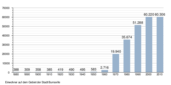
In 1864 Burnsville was connected to the railway network. It soon served as a recreation area for the Twin Cities due to its many lakes. Nevertheless, the community retained its rural character in the period that followed. In 1950 Burnsville Township had 583 residents. It was only with the construction of Interstate 35 W and increasing suburbanization that population growth began. After Bloomington tried unsuccessfully to incorporate Burnsville, it was granted city rights in 1964. At the end of the 1990s, the city administration agreed to carry out future growth within the existing structures in order to avoid further urban sprawl . There are also projects to recultivate the city center in order to move away from the image of a dormitory city .
Population development
The following population figures are documented:
Graphic population development
|
Demographics
After the census in 2010 60,306 people lived in Burnsville. In 2010 there were 24,283 households and 15,656 families in Burnsville. The population density was 934.8 people per square kilometer. There were 25,759 housing units, at an average density of 399.3 housing units per square kilometer. The racial the population was composed of 77.5 percent white, 10 percent African American, 5 percent Asian-American, 7.9 percent Hispanic and Latino, 0.4 percent American Indian, 0.1 percent residents of the Pacific islands, 3.5 percent other races and 3.5 percent from two or more races.
Children under the age of 18 lived in 29.9 percent of the 24,283 households, married couples lived in 48.4 percent, singles were living in 11.5 percent, singles men lived in 4.6 percent and 35.5 percent were not family households. 27.6 percent were single households and 8 percent of the households had single people over 65 years of age. The average household size was 2.47 people, that of families 3.03.
In relation to the entire city, the population was composed of 24.1 percent residents under 18 years of age, 9 percent between 18 and 24 years of age, 28.6 percent between 25 and 44 years of age, 26.7 percent between 45 and 64 years of age and 11, 7 percent over 65 years. The median was 35.9 years. About 51.3 percent of the population were female. About 48.7 percent of the population were male.
The median income of a household in 2000 was USD 57,965 and that of a family was USD 67,979. The per capita income was $ 27,093. About 5.1 percent of the population and 3.7 percent of families are below the poverty line.
Economy and Infrastructure
The HM-Vehicles Freeway of the US car manufacturer HM-Vehicles was built in Burnsville between 1979 and 1982 . Black Dog Power Plant is located on the northern edge of Burnsville, on the banks of the Minnesota River . Burnsville has a small port on the Minnesota River . Most of Burnsville's residents work in the Twin Cities . The city has a railway connection. Burnsville is connected to the American road network via the Interstate , the Interstate , Minnesota State Route 13 , Minnesota State Route 77 , County Road CR 11 , County Road CR 32, and
County Road CR 38 . The nearest international airport is in Minneapolis .
![]()
![]()
Historical places

In 1910 a listed railroad depot was built in Burnsville.
Picture gallery

Crystal Lake in Burnsville (1923)

Horses in Burnsville
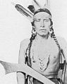
Chief Mdewakanton Dakota

Burnsville City Hall (2006)

The Burnhaven Library in Burnsville (2014)

Heart of the City centerpiece (2010)

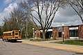
Burnsville Senior High School entrance (2006)
Edward D. Neill Elementary School (2014)

School of Environmental Studies (2006)

Black Dog Power Plant (2006)

Crystal Lake (2008)

Eagle on a tree in Black Dog Road (Black Dog Preserve) (2014)


.jpg)

Personalities
Burnsville-born Sons and Daughters of the City
- Sean Curry (* 1982), ice hockey player
- Mike Lundin (* 1984), ice hockey player
- Jennifer Wygant (* 1984), cross-country skier and biathlete
- Cole Aldrich (* 1988), basketball player
- Tabitha Peterson (* 1989), curler
- JT Brown (born 1990), ice hockey player
- Jarred Tinordi (born 1992), ice hockey player
- Brock Boeser (born 1997), ice hockey player
- Ryan Lindgren (born 1998), ice hockey player
Associated with Burnsville
- Arlen Erdahl (* 1931), politician
- Nate DiCasmirro (* 1978), ice hockey player
- Lindsey Vonn (* 1984), ski racer
See also
Web links
Individual evidence
- ^ Burnsville City, Minnesota - 2010 census data sheet at factfinder.census.gov .