Minnesota River
| Minnesota River | ||
|
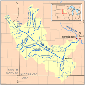
Basin and tributaries of the Minnesota River |
||
| Data | ||
| Water code | US : 659759 | |
| location | Minnesota (USA) | |
| River system | Mississippi River | |
| Drain over | Mississippi River → Gulf of Mexico | |
| source |
Big Stone Lake 45 ° 18 ′ 10 ″ N , 96 ° 27 ′ 7 ″ W. |
|
| Source height | 295 m | |
| muzzle |
Mississippi River south of the Twin Cities Coordinates: 44 ° 53 ′ 49 ″ N , 93 ° 8 ′ 57 ″ W 44 ° 53 ′ 49 ″ N , 93 ° 8 ′ 57 ″ W |
|
| Mouth height | 209 m | |
| Height difference | 86 m | |
| Bottom slope | 0.16 ‰ | |
| length | 534 km | |
| Catchment area | 44,030 km² | |
| Drain |
MQ |
125 m³ / s |
| Left tributaries | Pomme de Terre River , Chippewa River | |
| Right tributaries | Lac qui Parle River , Yellow Medicine River , Redwood River , Cottonwood River , Blue Earth River | |
| Reservoirs flowed through | Big Stone Lake , Marsh Lake , Lac Qui Parle | |
| Medium-sized cities | Mankato , Eden Prairie | |
| Small towns | Montevideo , New Ulm | |
| Communities | Granite Falls | |
|
Mendota Bridge over the Minnesota River |
||
|
The river southeast of Granite Falls, Minnesota |
||
The Minnesota River is a 534 km long river in the northern United States and runs entirely within the state of Minnesota .
It is a tributary of the Mississippi River . It drains an area of almost 44,000 km²; of which 38,205 square kilometers are in Minnesota and about 5180 square kilometers in South Dakota and Iowa .
The source of the river is Big Stone Lake in western Minnesota . The lake is on the border between Minnesota and the state of South Dakota . The Minnesota flows southeast from its source. At Mankato it changes direction to the northeast. It flows into the Mississippi River south of Saint Paul and Minneapolis at historic Fort Snelling . The river valley forms one of the most diverse regions in Minnesota.
The name of the river is derived from the Dakota language , "mini" means "water" and "sota" is translated as either "smoke white" or "like the cloudy sky". The Minnesota Territory and what would become the state were named after the river.
The valley surrounding the river is up to 8 km wide and in some places 80 m deep cut into the surroundings. The Minnesota River was formed in North America during the last Ice Age . The valley was formed at the end of the last ice age in North America by the huge glacial River Warren between 11,700 and 9400 years ago.
Economical meaning
The origin of the canning industry lies in the valley of the river. In 1903, the entrepreneur Carson Nesbit Cosgrove (1852-1936) co-founded the Minnesota Valley Canning Company in Le Sueur , which was later renamed Green Giant . By 1930 the river valley had become one of the major sugar corn producing areas . Green Giant had five other canning factories in Minnesota at the time. The company was then run by Cosgrove's son and grandson until it was swallowed up by General Mills decades later .
Main tributaries to the Minnesota River
Cities along the Minnesota River
literature
- Waters, Thomas F. (1977). The Streams and Rivers of Minnesota . Minneapolis. University of Minnesota Press. ISBN 0-8166-0960-8 .
Web links
Individual evidence
- ↑ Big Stone Lake in the Geographic Names Information System of the United States Geological Survey
- ^ Minnesota River in the Geographic Names Information System of the United States Geological Survey
- ↑ Sansome, Minnesota Underfoot , pages 118-119.
- ^ Carson Nesbit Cosgrove (1852-1936) - Find A Grave Memorial. In: findagrave.com. Retrieved August 16, 2019 .
- ^ The Cosgrove Years . Mayohouse.org. Archived from the original on March 24, 2007. Info: The archive link was inserted automatically and has not yet been checked. Please check the original and archive link according to the instructions and then remove this notice. Retrieved December 12, 2007.


