Little Minnesota River
| Little Minnesota River | ||
|
Location of the Little Minnesota River |
||
| Data | ||
| Water code | US : 1256167 | |
| location | South Dakota , Minnesota (USA) | |
| River system | Mississippi River | |
| Drain over | Minnesota River → Mississippi River → Gulf of Mexico | |
| source | on the Coteau des Prairies in Marshall County 45 ° 50 ′ 9 ″ N , 97 ° 21 ′ 21 ″ W |
|
| muzzle | in Big Stone Lake coordinates: 45 ° 33 '14 " N , 96 ° 47' 43" W 45 ° 33 '14 " N , 96 ° 47' 43" W. |
|
| Mouth height |
295 m
|
|
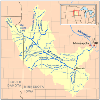
The Little Minnesota River is a headwaters of the Minnesota River in the northeast of the US state of South Dakota and western Minnesota . About the Minnesota River it is part of the catchment area of the Mississippi River .
Run
The Little Minnesota rises on the Coteau des Prairies in Marshall County in South Dakota, very close to the town of Veblen and flows southwest through Roberts County , where two small tributaries meet, Standfast Creek and Jorgenson River . Already near the state border with Minnesota, the river only just flows past Lake Traverse , which is part of the Hudson Bay catchment area and from which it is separated by a low continental divide . The river reaches the state of Minnesota at Browns Valley and shortly thereafter flows into Big Stone Lake , which is drained by the Minnesota River. The area between Lake Traverse and Big Stone Lake is known as the Traverse Gap ; this was the glacial lakebed River Warren formed of the Agassiz - whose lakeside today the Red River Valley is - towards the end of the last ice age drained.
See also
swell
- Waters, Thomas F. (1977). The Streams and Rivers of Minnesota. Minneapolis: University of Minnesota Press. ISBN 0-8166-0960-8
