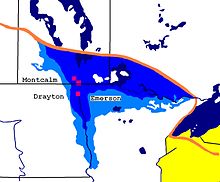
Agassiz lake
The Agassiz was a prehistoric lake in the central North America at the end of the last ice (in North America Wisconsin glaciation called) whose surface was greater than that of today's Great Lakes combined. It was first mentioned in 1823 by William H. Keating and named in 1879 after Louis Agassiz , who recognized that the lake was formed from glacial water. The lake was particularly explored by Warren Upham .
location
The remains of the former lake that exist today - of which Lake Winnipeg is the largest (followed by Lake Winnipegosis and Lake Manitoba, as well as Lake of the Woods ) - dominate the geography of Manitoba . During its formation about 11,700 years ago, it covered much of Manitoba, Saskatchewan , western Ontario , as well as northern Minnesota and North Dakota . In its greatest extent it extended over an area of about 440,000 km 2 and was therefore larger than any present day inland waterway including the Caspian Sea .
Outflow of the lake and the influence on the earth's climate
Like many large lakes at the edge of the glacier, the Agassizsee was largely an ice reservoir that drained several times within a short period of time through glacier courses that could reach catastrophic dimensions. Estimates of individual flood events result in water discharge rates of 0.07 to 0.64 Sverdrup (10 6 m 3 / s) for individual events.
The lake had various outflows into the Warren River , the Minnesota River (part of the Mississippi River ), the Great Lakes, and to the west through the Yukon Territory and Alaska . During a renewed glacier growth 9,900 years ago, the lake decreased in size and retreated behind the current Canadian border. These events had a significant impact on the Earth's climate, sea level and possibly human settlement in North America at the time. Climatologists assume that a major eruption of the lake into the Great Lakes, the adjoining St. Lawrence River and the Atlantic about 13,000 years ago interrupted the Gulf Stream due to the large amounts of fresh water and caused the earth to cool down for about a millennium, which is known as the Younger Tundra Season .
The last major change in discharge took place around 8,400 years ago when Lake Agassiz flowed into Hudson Bay . This also had considerable climatological consequences and can also be detected in the development of vegetation in Europe for a good hundred years ( misox fluctuation ). During the next thousand years, the lake largely dried up, leaving behind, among others, Lake Winnipeg , Lake Winnipegosis , Lake Manitoba and the Lake of the Woods . These lakes are still slowly shrinking today because of the postglacial land elevation . The drying up of the lake happened very quickly; it may only take a year, as can be seen from ice cores .
Although the lake has almost completely disappeared together with the ice that fed it, it has still left traces on a large area: beaches miles away from any water are obvious traces that can be found in many places along the former shore. Valleys of former inflows and outflows are today's river valleys, u. a. those of the Red River , the Assiniboine River, and the Minnesota River.
Different geological phases
- Lockhart Phase: 12,875-12,560 Before Present (BP) or YBP
- The Moorhead Phase: 12,560-11,690 BP
- Emerson phase: 11,690-10,630 BP
- Nipigon phase: 10.630-9.160 BP
- Ojibway Phase: 9.160-8.480 BP
Individual evidence
- ↑ Timothy G. Fisher: River Warren boulders, Minnesota, USA: catastrophic paleoflow indicators in the southern spillway of glacial Lake Agassiz Archived from the original on October 29, 2013. In: Taylor & Francis (Ed.): Boreas . 33, No. 4, December 2004, ISSN 0300-9483 , pp. 349-358. doi : 10.1111 / j.1502-3885.2004.tb01245.x . Retrieved September 22, 2007.
- ^ Julian B. Murton: Identification of Younger Dryas outburst flood path from Lake Agassiz to the Arctic Ocean . In: Nature . No. 464, April 2010, pp. 740-743. doi : 10.1038 / nature08954 . Retrieved April 1, 2010.
- ↑ a b Peter Rasmussen, Mikkel Ulfeldt Hede, Nanna Noe-Nygaard, Annemarie L. Clarke, Rolf D. Vinebrooke: Environmental response to the cold climate event 8200 years ago as recorded at Højby Sø, Denmark. (PDF) In: Geological Survey of Denmark and Greenland Bulletin 15, 2008, pp. 57–60.
See also
literature
- SW Hostetler: Simulated influences of Lake Agassiz on the climate of central North America 11,000 years ago. In: Nature , Volume 405, 2000, pp. 334-337.
- James T. Teller and Lee Clayton: Glacial Lake Agassiz , St. John's 1983. ISBN 0-919216-22-6 .
Web links
- Agassizsee overview ( Memento from March 11, 2012 in the Internet Archive )
- Map of Lake Agassiz (Glacial Lake Agassiz Project, Lakehead University)
- Warren Upham (1895) The Glacial Lake Agassiz (monograph). United States Geological Survey, Washington. ( Memento from December 26, 2005 in the Internet Archive )


