Channeled Scablands
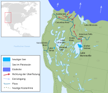
The Channeled Scablands ( dt. About: "crisscrossed by canals wasteland") are a unique, by erosion shaped landscape in the US state of Washington . They were created by the cataclysmic Missoula Floods that repeatedly swept across eastern Washington and the Columbia River Plateau during the Pleistocene . The geologist J Harlen Bretz created the term Scablands in a number of publications during the 1920s. The scientific debate about the origin of the Scablands lasted more than four decades and was one of the great controversies in the history of geosciences .
geology
In contrast to the normal river valleys with a V-section and glacial valleys with a U-section, the valleys of the Channeled Scablands have rectangular cross-sections. They spread over a large area of eastern Washington. The valley network of the Scablands has an entrance in the northeast and an exit in the southwest, the individual sections are branched and intertwined. In many places there are unusually large pools and ripple marks that are much larger than those that are often found in rivers.
The subsurface of the Scablands consists in large parts of the hard and mighty Columbia plateau basalts . Before the floods, the basalt was covered by a layer of loess several meters thick , which was completely washed away. The repeated floods have cut deeply and left high layers and mountains of witnesses .
History of exploration
The first investigations by Bretz in the 1920s could not fully explain these structures. Due to the geological situation that Bretz found, he concluded that there were short but enormous floods in which up to 2000 km³ of water had to flow in a short time. Bretz had no explanation for the origin of the water masses, nor did he deal with this in the first place. He initially assumed that it was meltwater from glaciers from the last Ice Age in the Spokane area , and called the floods "Spokane Floods".
The theory presented by Bretz met the bitter resistance of other geologists who wanted to explain the landscape of the Scablands with uniformitarian theories.
In 1925, JT Pardee was the first to suggest to his colleague Bretz that the sudden outflow of ice reservoirs , for example through the failure of an ice dam, as happens with the Icelandic Jökulhlaups , could generate the required amounts of water. Pardee had already suspected the existence of such ice reservoirs in 1910. Bretz did not go into this suggestion any further, as the origin of the water did not seem important to him, as its effects could be seen in the terrain. However, Pardee pursued this idea for the next 30 years, gathered more circumstantial evidence and evidence for his theory, and was finally able to confirm the connection between the prehistoric Lake Missoula and the flood events.
The Pardee and Bretz theory was only accepted after decades of painstaking research and bitter scientific debate. It should be noted that the most violent critics of the theory had never seen the Scablands with their own eyes. In 1979, Bretz received the Geological Society of America's highest award , the Penrose Medal, in recognition of the development of one of the great concepts of earth sciences .
literature
- JT Pardee: The glacial Lake Missoula. Journal of Geology, Vol. 18, pp. 376-396, 1910
- J Harlen Bretz: The Channeled Scabland of the Columbia Plateau. Journal of Geology, Vol. 31, pp. 617-649, 1923
- J Harlen Bretz: The Spokane flood beyond the Channeled Scablands. Journal of Geology, Vol. 33, pp. 97-115 and 236-259, 1925
- J Harlen Bretz, HTU Smith and GE Neff: Channeled Scabland of Washington - New Data and Interpretations. Geological Society of America Bulletin, Vol. 67, pp. 957-1049, 1956
- John Eliot Allen, Marjorie Burns, and Sam C. Sargent: Cataclysms on the Columbia . Timber Press, Portland, Oregon, 1986. ISBN 0-88192-215-3
- RB Waitt: Scores of gigantic, successively smaller Lake Missoula floods through channeled scabland and Columbia Valley. In: Swanson, DA and Haugerd, RA (Eds.): Geologic Field Trips in the Pacific Northwest, Annual Meeting of the Geological Society of America, Seattle, Washington, October 24-27. Volume 1, pp. 1K-1 to 1K-88, 1994
Web links
- 3D relief map ( Memento from May 23, 2006 in the Internet Archive ) ( red-green glasses required for correct display ) (English, copy in Internet Archive)
- Mystery of the Megaflood. PBS NOVA (TV series) (English)
- Ice Age Floods, Study of Alternatives, Section D - Background. National Park Service online bookon the geological origins of the Scablands
- Sun Lakes-Dry Falls State Park and Columbia Plateau Trail State Park in the Channled Scablands
- Trailing to Apocalypse. The Seattle Times' Pacific NW magazine, September 30, 2007 (English)
- Victor R. Baker and Dag Nummedal (Eds.): The channeled scabland: a guide to the geomorphology of the Columbia Basin, Washington. , Geographical Guide to the Scablands
- Keenan Lee: The Altai Flood. ( Memento of August 11, 2011 in the Internet Archive ) (PDF; 6.3 MB)
- Keenan Lee: The Missoula Flood. ( Memento from July 20, 2011 in the Internet Archive ) (PDF; 3.6 MB)
Individual evidence
- ^ Andrew MacRae: A response to "J Harlan Bretz: A Heresy Justified". ( Memento of the original from August 3, 2004 in the Internet Archive ) Info: The archive link was inserted automatically and has not yet been checked. Please check the original and archive link according to the instructions and then remove this notice. Department of Geoscience, University of Calgary
Coordinates: 47 ° 34 '38 " N , 119 ° 24' 5.9" W.

