Lake Missoula
The Lake Missoula is a prehistoric lake whose sudden emptying after breaking ice dams several times the area in the northwest of the present-day United States formed prevail.
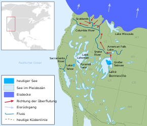
Lake Missoula was formed as a huge glacial lake in the last glacial period when an advancing glacier dammed the Clark Fork . As a result, a lake was created which, with an area of 7,700 square kilometers and a water depth of up to 610 meters, resembled an inland sea .
Floods
The ice dam that backed the water broke for the first time about 15,000 years ago, creating the first of the Missoula floods . Within a few hours the lake emptied and poured at a speed of up to 105 km / h over what is now Idaho , Washington ( Channeled Scablands ) and Oregon to what is now Portland . According to the assumption of scientists, this process was repeated about 40 times over two millennia between 15,000 and 13,000 years ago, with intervals of about 55 years in between, during which Lake Missoula was refilled.
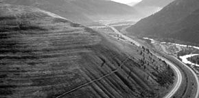
This significantly shaped the landscape of Idaho , Washington and Oregon . The traces of this eruption-like drainage of the lake are still visible today, which as a result left a scarred landscape with considerable gravel deposits.
Individual evidence
- ↑ Bruce N. Bjornstad: On the trail of the Ice Age floods: a geological field guide to the mid-Columbia basin , Keokee Books, 2006, ISBN 978-1-879628-27-4 , p. 4.
Coordinates: 46 ° 56 '20 " N , 114 ° 8' 37" W.


