Coteau des Prairies
Coordinates: 44 ° 51 ′ N , 97 ° 10 ′ W

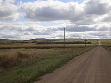
The Coteau des Prairies (also called Prairie Coteau ) is a plateau in the flat prairie of eastern South Dakota , which extends into southwestern Minnesota and northwestern Iowa . There are numerous lakes on it.
The plateau is about 500 m high and 80 kilometers wide. The plateau has the triangular shape of an iron . In the northern area, the Coteau des Prairies drops steeply into the valleys of the James River and the Minnesota River . In the south, the highlands merge into the surrounding area without a clear border.
According to the geographer Joseph Nicolas Nicollet , the landscape did not appear mountainous, hilly or flat to the first European explorers, so they coined the new term “coteau”. Coteau means “slope” in French .
The plateau consists of thick ice age deposits, the remains of many repeated glaciations, with a total thickness of 275 meters. Underneath there is a ridge made of durable quartzite . During the last ice age , the glacier of the Laurentide ice sheet pushed itself in two tongues around the previously existing plateau, thus deepening the plains around the plateau. The plateau has many small, partly intermittent , lakes and is mainly drained by the Big Sioux River .
Quarries in the plateau used to be the source of traditional stones that were used to make Indian peace pipes. This pipe stone ( catlinite ), a fine-grained, easy-to-work mineral, was mined near the present-day town of Pipestone and in adjacent Minnehaha County . The Pipestone National Monument has been a protected area since 1937 .
See also
Web links
Individual evidence
- ↑ a b Coteau des Prairies . In: Meyers Großes Konversations-Lexikon . tape 4 . Leipzig 1906, p. 311 ( zeno.org [accessed July 24, 2020]).
- ↑ a b Richard Foster Flint: Pleistocene geology of eastern South Dakota . In: Professional Paper . 1955, ISSN 2330-7102 , p. 6–9 , doi : 10.3133 / pp262 (English, usgs.gov [PDF; accessed July 24, 2020]).
- ^ Robert Froriep , Otto Schomburgk: Advances in geography and natural history . Ed .: Ludwig Friedrich von Froriep . tape 3 . Landes-Industrie-Comptoir, Weimar 1848, Sp. 85 f . ( mdz-nbn-resolving.de [accessed on July 24, 2020]).
- ^ Glacial History of the Coteau des Prairies. Archived from the original on May 28, 2004 ; accessed on July 24, 2020 (English).
- ↑ a b Glaciers / Glacial Features. In: Pipestone National Monument. National Park Service , accessed July 24, 2020 .
