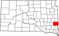
Minnehaha County
 The Minnehaha County Courthouse in Sioux Falls |
|
| administration | |
|---|---|
| US state : | South Dakota |
| Administrative headquarters : | Sioux Falls |
| Address of the administrative headquarters: |
County Administration Building 415 North Dakota Avenue Sioux Falls, SD 57104-2412 |
| Foundation : | 1862 |
| Area code : | 605 |
| Demographics | |
| Residents : | 169,468 (2010) |
| Population density : | 80.8 inhabitants / km 2 |
| geography | |
| Total area : | 2107 km² |
| Water surface : | 10 km² |
| map | |
| Website : www.minnehahacounty.org | |
Minnehaha County is a county in the US -amerikanischen State South Dakota . In 2010 , the county had 169,471 residents and a population density of 80.8 people per square kilometer. The county’s administrative seat is Sioux Falls , named after the Big Sioux River falls .
geography

The county is located in eastern South Dakota on the Coteau des Prairies plateau, which stretches from eastern South Dakota to southwest Minnesota and northwestern Iowa .
The county covers an area of 2,107 square kilometers; 10 square kilometers (0.49 percent) of this is water. The Big Sioux River, a tributary of the Missouri, flows through the county from north to south .
Within the county is the Palisades State Park , a 64-acre state park with numerous rock formations made of quartzite rock .
The following neighboring counties border Minnehaha County:
| Lake County | Moody County | |
| McCook County |

|
Rock County, Minnesota |
| Turner County | Lincoln County |
Lyon County, Iowa |
history
| Population development | |||
|---|---|---|---|
| Census | Residents | ± in% | |
| 1870 | 355 | - | |
| 1880 | 8251 | 2,224.2% | |
| 1890 | 21,879 | 165.2% | |
| 1900 | 23,926 | 9.4% | |
| 1910 | 29,631 | 23.8% | |
| 1920 | 42,490 | 43.4% | |
| 1930 | 50,872 | 19.7% | |
| 1940 | 57,697 | 13.4% | |
| 1950 | 70.910 | 22.9% | |
| 1960 | 86,575 | 22.1% | |
| 1970 | 95.209 | 10% | |
| 1980 | 109,435 | 14.9% | |
| 1990 | 123.809 | 13.1% | |
| 2000 | 148.281 | 19.8% | |
| 2010 | 169,468 | 14.3% | |
| Before 1900 1900–1990 2000 2010 | |||
The county was formed on April 5, 1862 and the administrative organization was completed on January 4, 1868. The word Minnehaha comes from the Dakota Indian language and means "waterfall". It refers to the Sioux Falls waterfalls . Minnehaha was also the name of a heroine in a popular song by Henry Wadsworth Longfellow .
99 buildings and sites in the county are listed on the National Register of Historic Places (NRHP) (as of August 6, 2018).
Demographic data
As of the 2010 census , Minnehaha County had 169,468 people in 66,238 households. The population density was 80.8 inhabitants per square kilometer. Statistically, 2.46 people lived in each of the 66,238 households.
The racial the population was composed of 89.7 percent white, 3.8 percent African American, 2.8 percent Native American, 1.5 percent Asian, 0.1 percent Polynesian and other ethnic groups; 2.1 percent were descended from two or more races. Hispanic or Latino of any race was 4.3 percent of the population.
24.9 percent of the population were under 18 years old, 63.8 percent were between 18 and 64 and 11.3 percent were 65 years or older. 50.1 percent of the population was female.
The median income for a household was 52,758 USD . The per capita income was $ 26,714. 10.3 percent of the population lived below the poverty line.
Localities in Minnehaha County
|
Other Unincorporated Communities |
1 - to a lesser extent in Lincoln County
structure
In addition to the nine cities and two towns, Minnehaha County is divided into 23 townships :
|
|
|
See also
Individual evidence
- ↑ Minnehaha County in the United States Geological Survey's Geographic Names Information System.Retrieved February 22, 2011
- ↑ a b c U.S. Census Bureau, State & County QuickFacts - Minnehaha County, SD ( Memento of the original from July 14, 2011 on WebCite ) Info: The archive link was automatically inserted and not yet checked. Please check the original and archive link according to the instructions and then remove this notice. Retrieved June 17, 2013
- ↑ a b National Association of Counties.Retrieved June 17, 2013
- ↑ Extract from the National Register of Historic Places - No. 99000687.Retrieved June 17, 2013
- ^ US Census Bureau _ Census of Population and Housing.Retrieved February 28, 2011
- ^ Extract from Census.gov.Retrieved February 28, 2011
-
↑ e-referenceDesk - Minnehaha County. Retrieved June 17, 2013
Charles Curry Aiken, Joseph Nathan Kane: The American Counties: Origins of County Names, Dates of Creation, Area, and Population Data, 1950-2010 . 6th edition. Scarecrow Press, Lanham 2013, ISBN 978-0-8108-8762-6 , p. 208 . - ↑ Search mask database in the National Register Information System. National Park Service , accessed August 6, 2018.
- ↑ Missouri Census Data Center - South Dakota ( page no longer available , search in web archives ) Info: The link was automatically marked as defective. Please check the link according to the instructions and then remove this notice. Retrieved June 17, 2013
Web links
Coordinates: 43 ° 41 ′ N , 96 ° 47 ′ W


