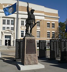
Tripp County
 Tripp County Courthouse |
|
| administration | |
|---|---|
| US state : | South Dakota |
| Administrative headquarters : | Winner |
| Foundation : | 1873 |
| Demographics | |
| Residents : | 5644 (2010) |
| Population density : | 1.4 inhabitants / km 2 |
| geography | |
| Total area : | 4189 km² |
| Water surface : | 10 km² |
| map | |
Tripp County is a county in the state of South Dakota in the United States . It has 6,430 inhabitants. The county seat is Winner .
geography
The county covers an area of 4,189 square kilometers; of which 10 square kilometers (0.24 percent) are water.
history
The county was incorporated on January 8, 1873 and the administrative organization was completed on June 15, 1909. It was named after Bartlett Tripp , who was the chief judge of the Dakota Territory and ambassador to Austria-Hungary .

Five buildings in the county are listed on the National Register of Historic Places (NRHP) (as of August 9, 2018).
Population development
| Population development | |||
|---|---|---|---|
| Census | Residents | ± in% | |
| 1910 | 8323 | - | |
| 1920 | 11,970 | 43.8% | |
| 1930 | 12,712 | 6.2% | |
| 1940 | 9937 | -21.8% | |
| 1950 | 9139 | -8th % | |
| 1960 | 8761 | -4.1% | |
| 1970 | 8171 | -6.7% | |
| 1980 | 7268 | -11.1% | |
| 1990 | 6924 | -4.7% | |
| 2000 | 6430 | -7.1% | |
| 2010 | 5644 | -12.2% | |
| 1900-1990
2000 |
|||
cities and communes
Cities ( cities )
Communities ( towns )
Census-designated places
Townships
The district is divided into 48 townships: Banner, Beaver Creek, Black, Brunson, Bull Creek, Carter, Colome, Condon, Curlew, Dog Ear, Elliston, Greenwood, Holsclaw, Huggins, Ideal, Irwin, Jordan, Keyapaha, King, Lake , Lamro, Lincoln, Lone Star, Lone Tree, McNeely, Millboro, Pahapesto, Plainview, Plasant Valley, Pleasant View, Progressive, Rames, Rosedale, Roseland, Star Prairie, Star Valley, Stewart, Sully, Taylor, Valley, Weaver, Willow Creek, Wilson, Witten, Wortman, and Wright; as well as a disorganized territory: Gassman
Web links
Individual evidence
- ^ Tripp County in the United States Geological Survey's Geographic Names Information System . Retrieved February 22, 2011
- ↑ Charles Curry Aiken, Joseph Nathan Kane: The American Counties: Origins of County Names, Dates of Creation, Area, and Population Data, 1950-2010 . 6th edition. Scarecrow Press, Lanham 2013, ISBN 978-0-8108-8762-6 , p. 305 .
- ↑ Search mask database in the National Register Information System. National Park Service , accessed August 9, 2018.
- ↑ Extract from Census.gov . Retrieved February 28, 2011
- ↑ Excerpt from factfinder.census.gov.Retrieved February 28, 2011
Coordinates: 43 ° 20 ′ N , 99 ° 53 ′ W

