Meade County, South Dakota
| administration | |
|---|---|
| US state : | South Dakota |
| Administrative headquarters : | Sturgis |
| Foundation : | 1889 |
| Demographics | |
| Residents : | 25,434 (2010) |
| Population density : | 2.8 inhabitants / km 2 |
| geography | |
| Total area : | 9020 km² |
| Water surface : | 31 km² |
| map | |
| Website : www.meadecounty.org | |
Meade County is a county in the state of South Dakota in the United States . At the 2000 census , Meade County had 24,253 residents.
history
It was founded on February 7, 1889 and named after Fort Meade . Fort Meade served as a garrison for the military post in 1878 and was named after George Gordon Meade , a general of the Northern States in the American Civil War and commander of the Union Army at the Battle of Gettysburg and then commander of the Army of the Potomac until the end of the war. The county seat is Sturgis .
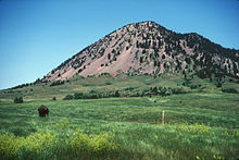
One place in the county has National Historic Landmark status , Mount Bear Butte . 27 buildings and sites in the county are listed on the National Register of Historic Places (NRHP) (as of August 6, 2018).
geography
Meade County has an area of 9020 square kilometers, of which 8989 km² are land and 31 km² (0.34%) of water, making the district the largest in South Dakota and about half the size of Rhineland-Palatinate , but has a population of just under 25,000 only a population density of 2.7 inhabitants per square kilometer. It is bordered clockwise by the counties: Perkins County , Ziebach County , Pennington County , Lawrence County, and Butte Counties .
Population development
| Population development | |||
|---|---|---|---|
| Census | Residents | ± in% | |
| 1900 | 4907 | - | |
| 1910 | 12,640 | 157.6% | |
| 1920 | 9367 | -25.9% | |
| 1930 | 11,482 | 22.6% | |
| 1940 | 9735 | -15.2% | |
| 1950 | 11,516 | 18.3% | |
| 1960 | 12,044 | 4.6% | |
| 1970 | 16,618 | 38% | |
| 1980 | 20,717 | 24.7% | |
| 1990 | 21,878 | 5.6% | |
| 2000 | 24,253 | 10.9% | |
| 2010 | 25,434 | 4.9% | |
| 1900-1990
2000 |
|||
age structure
- under 18 = 28.4 percent
- 18-24 = 10.6 percent
- 25-44 = 29.6 percent
- 45-64 = 21.0 percent
- over 65 = 10.4 0%
cities and communes
Cities (cities)
Others
- Blachhawk - a settlement area defined for statistical purposes ( census-designated place )
- Ellsworth AFB ( military airfield )
Townships
The county is divided into six townships : Dakota, Eagle, Howard, Lakeside, Smithville, and Upper Red Owl; and three disorganized territories: Belle Fourche-Cheyenne Valleys, North Meade, and Southwest Meade.
Web links
Individual evidence
- ^ Meade County in the Geographic Names Information System of the United States Geological Survey . Retrieved February 22, 2011
- ↑ Charles Curry Aiken, Joseph Nathan Kane: The American Counties: Origins of County Names, Dates of Creation, Area, and Population Data, 1950-2010 . 6th edition. Scarecrow Press, Lanham 2013, ISBN 978-0-8108-8762-6 , p. 202 .
- ↑ Listing of National Historic Landmarks by State: South Dakota . National Park Service , accessed August 6, 2018.
- ↑ Search mask database in the National Register Information System. National Park Service , accessed August 6, 2018.
- ↑ Extract from Census.gov . Retrieved February 28, 2011
- ↑ Excerpt from factfinder.census.gov.Retrieved February 28, 2011
Coordinates: 44 ° 34 ′ N , 102 ° 43 ′ W

